Simsbury is a town in Hartford County, Connecticut, United States, incorporated as Connecticut's 21st town in May 1670. The town is part of the Capitol Planning Region. The population was 24,517 in the 2020 census.

The Lenape, also called the Lenni Lenape and Delaware people, are an Indigenous people of the Northeastern Woodlands, who live in the United States and Canada.

King Philip's War was an armed conflict in 1675–1676 between a group of indigenous peoples of the Northeastern Woodlands against the English New England Colonies and their indigenous allies. The war is named for Metacom, the Pokanoket chief and sachem of the Wampanoag who had adopted the English name, Philip, because of the friendly relations between his father Massasoit and the Plymouth Colony. The war continued in the most northern reaches of New England until the signing of the Treaty of Casco Bay on April 12, 1678.

Wampum is a traditional shell bead of the Eastern Woodlands tribes of Native Americans. It includes white shell beads hand-fashioned from the North Atlantic channeled whelk shell and white and purple beads made from the quahog or Western North Atlantic hard-shelled clam.

Western Massachusetts, known colloquially as "western Mass," is a region in Massachusetts, one of the six U.S. states that make up the New England region of the United States. Western Massachusetts has diverse topography; 22 colleges and universities including UMass in Amherst, MA, with approximately 100,000 students; and such institutions as Tanglewood, the Springfield Armory, and Jacob's Pillow.

The Farmington River is a river, 46.7 miles (75.2 km) in length along its main stem, located in northwest Connecticut with major tributaries extending into southwest Massachusetts. The longest route of the river, from the origin of its West Branch, is 80.4 miles (129.4 km) long, making it the Connecticut River's longest tributary by 2.3 miles (3.7 km) over the Westfield River directly to its north. The Farmington River's watershed covers 609 square miles (1,580 km2). Historically, the river played an important role in small-scale manufacturing in towns along its course, but it is now mainly used for recreation and drinking water.
The Massachusett are a Native American tribe from the region in and around present-day Greater Boston in the Commonwealth of Massachusetts. The name comes from the Massachusett language term for "At the Great Hill," referring to the Blue Hills overlooking Boston Harbor from the south.

The Saybrook Colony was a short-lived English colony established in New England in 1635 at the mouth of the Connecticut River in what is today Old Saybrook, Connecticut. Saybrook was founded by a group of Puritan noblemen as a potential political refuge from the personal rule of Charles I. They claimed possession of the land via a deed of conveyance from Robert Rich, 2nd Earl of Warwick, which granted the colony the land from the Narragansett Bay to the Pacific Ocean. Saybrook was named in honor of two of its primary investors, the Lords Saye and Sele and Brooke. John Winthrop the Younger was contracted as the colony's first governor, but quickly left Saybrook after failing to enforce its authority over Connecticut's settlers. With Winthrop gone, Lion Gardiner was left in charge of Saybrook's considerable fort, defending it when it was besieged during the Pequot War. Governor George Fenwick arrived in the colony in 1639, but quickly saw it as a lost cause. Fenwick negotiated the colony's sale to Connecticut in 1644 after interest in colonization dried up due to the investors' involvement in the English Civil War. The colony's founding document, the Warwick Patent, was used to justify the existence of the Connecticut Colony, which lacked a formal charter until 1662.
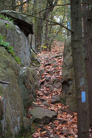
The Metacomet Trail is a 62.7-mile (100.9 km) Blue-Blazed hiking trail that traverses the Metacomet Ridge of central Connecticut as part of the New England National Scenic Trail. Despite being easily accessible and close to large population centers, the trail is considered remarkably rugged and scenic. The route includes many areas of unique ecologic, historic, and geologic interest. Notable features include waterfalls, dramatic cliff faces, woodlands, swamps, lakes, river flood plain, farmland, significant historic sites, and the summits of Talcott Mountain and the Hanging Hills. The Metacomet Trail is maintained largely through the efforts of the Connecticut Forest and Park Association.

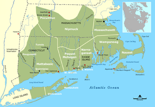
The Wappinger were an Eastern Algonquian Munsee-speaking Native American people from what is now southern New York and western Connecticut.
The Tunxis were a group of Quiripi speaking Connecticut Native Americans that is known to history mainly through their interactions with English settlers in New England. Broadly speaking, their location makes them one of the Eastern Algonquian-speaking peoples of Northeastern North America, whose languages shared a common root. More locally they were one of a number of Native communities in the lower Connecticut River Valley who shared common cultural traits.
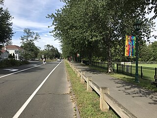
The Simsbury Center Historic District is a 75-acre (30 ha) historic district located in the town center area of Simsbury, Connecticut. It encompasses seven blocks of Hopmeadow Street, as well as the cluster of commercial, civic, and residential buildings along Railroad, Station, and Wilcox Streets, and Phelps Lane. Although its oldest element is the cemetery, most of its buildings were built in the late 19th and early 20th century. It was listed on the National Register of Historic Places in 1996.
Mattabesset was a region and settlement once occupied by Algonquian language-speaking Native Americans called the Wangunk, along the Connecticut River. The Mattabesset River reaches the Connecticut River near Middletown, Connecticut. European settler colonists established Middletown on the part of the region on the west side of the river, and a succession of settlements on the east side of the river, including Chatham and Middle Haddam, became East Hampton, Connecticut.

The Tunxis Trail is a 79-mile (127 km) Blue-Blazed hiking trail "system" that traverses the western ridge of the central Connecticut Valley. The mainline trail is not completely contiguous, notably there are two gaps of several miles.

The Horace Belden School and Central Grammar School are a pair of architecturally distinguished Late Gothic Revival occupying a single campus at 933 Hopmeadow Street and 29 Massaco Street in Simsbury, Connecticut. The Belden School was built in 1907 as the first Simsbury High School, and now serves as Simsbury Town Hall. The Central Grammar School, built in 1913, is now called the Central School. The buildings were listed as a pair on the National Register of Historic Places in 1993 for their architecture and their role in the town's educational system.

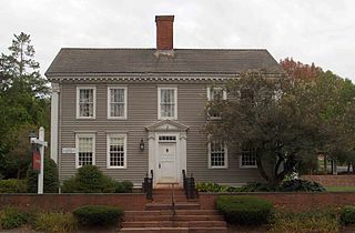
The Nathaniel Holcomb III House, also known as the Isaac Porter House, is a historic house at 45 Bushy Hill Road in Granby, Connecticut. It is locally significant as the residence of Nathaniel Holcomb III, a prominent resident, and as a well-preserved example of early 18th century residential construction.

The Battle of Bloody Brook was fought on September 28, 1675 between an indigenous war party primarily composed of Pocumtuc warriors and other local indigenous people from the central Connecticut River valley, and the English colonial militia of the New England Confederation and their Mohegan allies during King Philip's War.
Chickens Warrups, in some accounts referenced as Chicken Warrups or Sam Mohawk, was a Native American who lived in the southwestern part of Connecticut in the late 17th century and 18th century, at the time colonial settlers were establishing town governments, church parishes, and farms in the region. Warrups' name appears on multiple deeds awarding land to colonial settlers.
The Wangunk or Wongunk are an Indigenous people from central Connecticut. They had three major settlements in the areas of the present-day towns of Portland, Middletown, and Wethersfield. They also used lands in other parts of what were later organized by English settlers as Middlesex and Hartford counties. Some sources call the Wangunk the Mattabessett, or Mattabesch, but Wangunk is the name used by scholars and by contemporary Wangunk descendants.

The Indigenous peoples of Maryland are the tribes who historically and currently live in the land that is now the State of Maryland in the United States of America. These tribes belong to the Northeastern Woodlands, a cultural region.
