
Soria is a municipality and a Spanish city, located on the Douro river in the east of the autonomous community of Castile and León and capital of the province of Soria. Its population is 38,881, 43.7% of the provincial population. The municipality has a surface area of 271,77 km2, with a density of 144.97 inhabitants/km2. Situated at about 1065 metres above sea level, Soria is the second highest provincial capital in Spain.

Ciudad Lineal is one of 21 districts of Madrid, Spain.

The Ribera del Duero is a comarca or district located at the southern tip of the province of Burgos, part of the Spanish autonomous community of Castile and León. The capital of the Ribera del Duero comarca or district is the town of Aranda de Duero.

Calatayud is a Spanish Denominación de Origen Protegida (DOP) for wines located in the southwestern corner of the province of Zaragoza about 90 km from Zaragoza and covers over 5,600 ha, extending over 46 different municipalities, including Calatayud itself. It borders with the Cariñena (DO) in the east and with the province of Soria in the west. It is in the Ebro River valley and is crisscrossed by many of the Ebro's tributaries including the Jalón, Jiloca, Manubles, Mesa (river), Piedra and Ribota. The vineyards are found on the south facing slopes of the Sierra de la Virgen range at heights of between 550 m and 800 m above sea level.

Navaleno, which means "Meadow of Hay", is a municipality located to the northwest of the province of Soria, in the autonomous community of Castile and León, in Spain.
Magallón is a Spanish municipality, in the province of Saragossa, autonomous community of Aragon. It has an area of 78.61 km², with a population of 1221 inhabitants and a density of 15.53 inhab/km².

Torrellas is a municipality located in the province of Zaragoza, Aragon, Spain. According to the 2004 census (INE), the municipality has a population of 312 inhabitants.

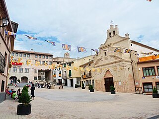
Arcos de Jalón is a municipality located in the province of Soria, Castile and León, Spain. As of 2009, it had a population of 1,782.

Covaleda is a municipality located in the province of Soria, Castile and León, Spain. According to the 2004 census (INE), the municipality had a population of 1,924 inhabitants.

The Castle of Ucero is a medieval defensive construction located in Ucero, in the province of Soria.

The Numantine Museum of Soria located in Soria, Spain, focuses on the prehistory and history of the province of Soria through art and archaeology. The name chosen for the museum, which means pertaining to Numantia, reflects the historical importance of Spain's most famous hill fort, which is a few kilometres from Soria.
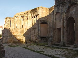
The Church of San Nicolás de Soria is now only ruined remnants of a Romanesque-style, Roman Catholic, former church located in Soria, Spain. It was declared Bien de Interés Cultural in 1962.
Montuenga Castle in the province of Soria, Spain forms part of the defensive line of the Jalón River set in a natural passage between the central plateau of Spain and the strategic basin of the Ebro.

Torremocha de Ayllón is a village in Soria, Spain. It is part of the municipality of San Esteban de Gormaz.

Piquera de San Esteban is a village in Soria, Spain. It is part of the municipality of San Esteban de Gormaz. The village had 50 inhabitants in 2001.
Torralba del Moral is a village under the local government of the municipality of Medinaceli, Soria, Spain. It has a railway station at a junction where the branch to Soria splits from the Madrid-Zaragoza line.

Aguilar de Montuenga is a village under the local government of the municipality of Arcos de Jalón, Soria, Spain.

Soria is one of the 59 constituencies represented in the Senate of Spain, the upper chamber of the Spanish parliament, the Cortes Generales. The constituency elects four senators. Its boundaries correspond to those of the Spanish province of Soria. The electoral system uses an open list partial block voting, with electors voting for individual candidates instead of parties. Electors can vote for up to three candidates.
Duáñez is a locality and also a minor local entity in the province of Soria, in the judicial district of Soria, in the autonomous community of Castile and León, Spain. It is a village in the Comarca of Campo de Gómara that belongs to the municipality of Candilichera.

The Palacio de los Castejones is a plateresque 16th-century palace located in Soria, Spain. It is located at the Aduana Vieja street next to other renaissance palaces of the city. It was built by the Castejón family, which is of great weight in this region of Castile. In the nearby village of Agreda, there is another palace called Palacio de los Castejón.

