Burgos is a city in Spain located in the autonomous community of Castile and León. It is the capital and most populated municipality of the province of Burgos.

Valladolid is a province of northwest Spain, in the central part of the autonomous community of Castile and León. It has a population of 520,716 people in a total of 225 municipalities, an area of 8,110 km2 (3,130 sq mi) and a population density of 64.19 people per km2.

The Province of Burgos is a province of northern Spain, in the northeastern part of the autonomous community of Castile and León. It is bordered by the provinces of Palencia, Cantabria, Vizcaya, Álava, La Rioja, Soria, Segovia, and Valladolid. Burgos is the province of Spain that has borders with most provinces. Its capital is the city of Burgos.

Soria is a municipality and a Spanish city, located on the Douro river in the east of the autonomous community of Castile and León and capital of the province of Soria. Its population is 38,881, 43.7% of the provincial population. The municipality has a surface area of 271,77 km2, with a density of 144.97 inhabitants/km2. Situated at about 1065 metres above sea level, Soria is the second highest provincial capital in Spain.

Aranda de Duero is a city and municipality, capital of the Ribera del Duero comarca, in the south of the province of Burgos, in Castile and León, Spain. It has a population of roughly 33,000 people and lies on the River Duero. The closest international airport is Madrid Barajas.

The Castle of Gormaz is a large castle located in Gormaz, Spain. Its current structure was built in 965 to defend the borders of the Caliphate of Cordoba. At the time of its construction, it was the largest fortress in Europe.
The N-122 is a highway in Spain. It connects Valladolid and Zaragoza to the Portugal–Spain border, where it connects to the A4 motorway (Portugal), this section was formerly the IP-4 and is now part of the European route E82 to Matosinhos. The border is formed by the Rio Macãs it heads east crossing the Esla river to Zamora and the Duero river valley. The N-630 crosses to the north and south.

The Ribera del Duero is a comarca or district located at the southern tip of the province of Burgos, part of the Spanish autonomous community of Castile and León. The capital of the Ribera del Duero comarca or district is the town of Aranda de Duero.

Navaleno, which means "Meadow of Hay", is a municipality located to the northwest of the province of Soria, in the autonomous community of Castile and León, in Spain.

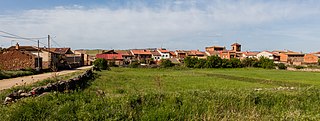
Nava de Roa is a municipality and town located in the municipality of Ribera del Duero, province of Burgos, Castile and León, Spain. It is located 92 km from Burgos, 26 km from Aranda de Duero, and 70 km from Valladolis. According to the 2004 census (INE), the municipality has a population of 246 inhabitants.

Vadocondes is a municipality located in the province of Burgos, Castile and León, Spain. It's located in the Ribera del Duero region, on the meander at the start of the River Duero. Vadocondes is about 13 kilometers from Aranda de Duero, in the direction of San Esteban de Gormaz.

Almazán is a municipality located in the province of Soria, Castile and León, Spain. As of 2013, the municipality has a population of 5,843 inhabitants. It is also the seat of the judicial district of Almazán, and ecclesiastically it belongs to the Diocese of Osma, a suffragan diocese of the Archdiocese of Burgos. Connected via the Autovía A-15 and Carretera nacional N-111, it is situated 194 kilometres (121 mi) by road northeast of Madrid. The town lies on the east bank of the Duero river.

Berlanga de Duero is a municipality located in the province of Soria, in the autonomous region of Castile and León, Spain. According to the 2017 census, the municipality has a population of 902 inhabitants.

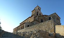
Gormaz is a municipality located in the province of Soria, Castile and León, Spain. According to the 2004 census (INE), the municipality has a population of 19 inhabitants. The Arab Gormaz Castle is the oldest and largest citadel in Western Europe of its time.
Montejo de Tiermes is a municipality located in the province of Soria, Castile and León, Spain. In 2010 the population of Montejo de Tiermes (municipality) was 198 inhabitants, 126 men and 72 women. Montejo de Tiermes (locality) had a population of 58 inhabitants on 1 January 2010, 41 men and 17 women.
Quintanas de Gormaz is a municipality located in the province of Soria, Castile and León, Spain. According to the 2004 census (INE), the municipality has a population of 192 inhabitants.

Soria is a city located in modern-day north-central Spain. As of 2010, the municipality has a population of approximately 39,500 inhabitants, nearly 40% of the population of the province.

The Way of El Cid is a cultural and tourist route that crosses Spain from the northwest to the southeast, from Castilla to the Mediterranean coast. It follows the history and the legend of Rodrigo Díaz de Vivar, El Cid Campeador, a medieval knight of the 11th century and one of Spain’s greatest characters. El Cid is not only a literary character, also a historical figure.