Matata | |
|---|---|
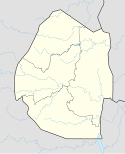 Matata Location of Matata in Eswatini | |
| Coordinates: 26°52′00″S31°55′28″E / 26.86667°S 31.92444°E | |
| Country | |
| Elevation | 110.31 m (361.91 ft) |
| Population (2014 Estimated) | |
| • Total | 3,000+ [1] |
| Climate | Cwb |
Matata | |
|---|---|
| Matata Location of Matata in Eswatini | |
| Coordinates: 26°52′00″S31°55′28″E / 26.86667°S 31.92444°E | |
| Country | |
| Elevation | 110.31 m (361.91 ft) |
| Population (2014 Estimated) | |
| • Total | 3,000+ [1] |
| Climate | Cwb |
The town is located on the southern banks of the Maputo River, in Lubombo Region, in the southeastern part of the country, close to the border with the Republic of South Africa, approximately 130 kilometres (81 mi), by road, south-east of Mbabane, the largest city and capital of Swaziland. [2] The geographical coordinates of Matata, Swaziland are: 26°52'00.0"S, 31°55'28.0"E (Latitude:-26.866672; Longitude:31.924455). [3] Matata sits at an average elevation of 110.31 metres (362 ft), above sea level. [4]
Matata the town, is home to the business known as Matata Group of Companies. The businesses include supermarkets, retail stores, farm machinery outlets, abattoirs, cattle ranches, a butchery, sugar farms, and maize plantations. The majority of adults in Matata the town, are employed in Matata the business group. [1]
In 2014, the population of Matata, was estimated at over 3,000 people. [1]
Eswatini Bank, the only indigenous commercial bank in Eswatini, [5] maintains a branch in Matata. [6]

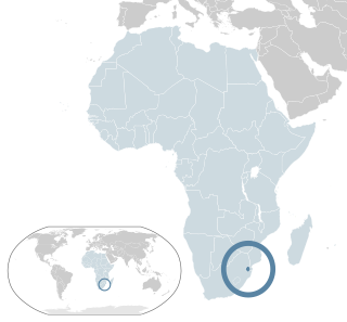
Eswatini, formally the Kingdom of Eswatini and formerly named Swaziland, is a landlocked country in Southern Africa. It is bordered by Mozambique to its northeast and South Africa to its north, west, south, and southeast. At no more than 200 km (120 mi) north to south and 130 km (81 mi) east to west, Eswatini is one of the smallest countries in Africa; despite this, its climate and topography are diverse, ranging from a cool and mountainous highveld to a hot and dry lowveld.
The Umbutfo Eswatini Defence Force (UEDF) is the military of the Southern African Kingdom of Eswatini (Swaziland). It is used primarily during domestic protests, with some border and customs duties; the force has never been involved in a foreign conflict. The army has struggled with high rates of HIV infection. Since measures were put in place the rate is dropping.

Mbabane is a city in Eswatini, and is one of the two capitals, serving as the executive capital.

Mswati III is Ngwenyama (King) of Eswatini and head of the Swazi royal family.

Hhohho is a region of Eswatini, located in the north western part of the country. Hhohho was named after the capital of King Mswati II, who expanded the Swazi territory to the north and west, taking in the districts of Barberton, Nelspruit, Carolina and Piet Retief. These areas were later acquired by what was the Province of Transvaal and today they form part of the Mpumalanga Province of South Africa. It has an area of 3,625.17 km², a population of 320,651 (2017), and is divided into 14 tinkhundla. The administrative center is the national capital of Mbabane. It borders Lubombo Region on the southeast and Manzini Region in the southwest.
Royal Swazi National Airways Corporation was the national airline of the Kingdom of Swaziland. Headquartered in Mbabane with its operational base at Matsapha Airport near Manzini, the airline was founded in 1978. The company still exists, since 2018 under the name Royal Eswatini National Airways Corporation (RENAC), although it does not own an airline, but provides services in the airline sector.
Lobamba is a city in Eswatini, and is one of the two capitals, serving as the legislative, traditional, spiritual, seat of government of the Parliament of Eswatini, and Ludzidzini Royal Village, the residence of Queen Ntfombi, the Queen Mother.

Manzini is a large city in Eswatini (Swaziland), which is also the capital of Eswatini's Manzini Region. The city is the country's second largest urban center behind Mbabane, with a population of 110,000 (2008). It is known as "The Hub" of Eswatini and lies on the MR3 road. Eswatini's primary industrial site at Matsapha lies near the town's western border.

Mbabane Swallows Football Club is a Eswatini football club based in Mbabane.
Lesbian, gay, bisexual, and transgender (LGBT) rights in Eswatini are limited. LGBT people face legal challenges not experienced by non-LGBT residents. According to Rock of Hope, a Swati LGBT advocacy group, "there is no legislation recognising LGBTIs or protecting the right to a non-heterosexual orientation and gender identity and as a result [LGBT people] cannot be open about their orientation or gender identity for fear of rejection and discrimination". Homosexuality is illegal in Eswatini, though this law is in practice unenforced. According to the 2021 Human Rights Practices Report from the US Department of State, "there has never been an arrest or prosecution for consensual same-sex conduct."
Education in Eswatini includes pre-school, primary, secondary and high schools, for general education and training (GET), and universities and colleges at tertiary level.
Matsapha is a town in central Eswatini. The Matsapha urban boundary is defined in the Urban Government Act of 1969, as amended in 2012, and covers an area of approximately 2,000 hectares. Matsapha was established as an industrial park in 1965 and was officially gazetted as an urban area in 1969. Matsapha is located in the Upper Middleveld of Eswatini in the Manzini region, which is in the centre of the country. Matsapha is 11 km (7 mi) from the city of Manzini, the country's commercial capital, and 35 km (22 mi) from Mbabane, the administrative capital of the country. It is well located as it is on Eswatini's main east–west axis between South Africa and Mozambique, 16 km (10 mi) from the junction of the Lavumisa road that leads to Durban and KwaZulu Natal. It lies at an altitude of 625 m (2,051 ft) above sea level.
Prostitution in Eswatini is illegal, the anti-prostitution laws dating back to 1889, when the country Eswatini was a protectorate of South Africa. Law enforcement is inconsistent, particularly near industrial sites and military bases. Police tend to turn a blind eye to prostitution in clubs. There are periodic clamp-downs by the police.

The Ngwenya Mine is located on Bomvu Ridge, northwest of Mbabane and near the northwestern border of Eswatini (Swaziland). This mine is considered to be the world's oldest. The haematite ore deposit was used in the Middle Stone Age to extract red ochre, while in later times the deposit was mined for iron smelting and iron ore export.

Eswatini–South Africa relations refers to the current and historical relationship between Eswatini and South Africa. South Africa surrounds Eswatini on the north, west and south. The two states share strong historical and cultural ties. Mutual High Commissions were established in Pretoria and Mbabane at the end of the apartheid era in 1994. Eswatini's High Commission in Pretoria is also cross-accredited to Botswana, Lesotho, Namibia, Zambia and Zimbabwe.
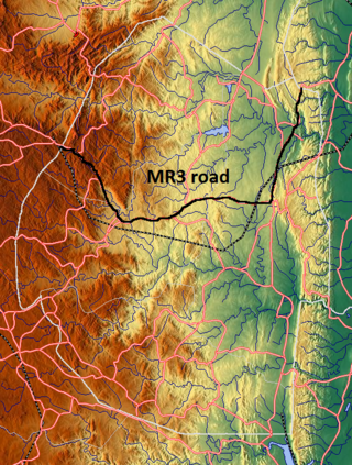
The MR3 road, also known as the Matsapha–Mbabane–Ngwenya road or Road No. MR3, is a major highway of Eswatini. It is one of the most heavily trafficked roads in the country, crossing it from east to west. Along with the MR7 and MR8 roads, it forms the "backbone of Swaziland's internal transport system." It connects the EN5 road in Mozambique near Namaacha at 25°59′21″S31°59′53″E to the N17 road in South Africa at 26°12′45″S30°59′18″E, near Ngwenya. The road passes through Hlane Royal National Park and through the capital of Mbabane, about 110 kilometres (68 mi) further to the southwest. The highway descends into the Ezulwini Valley in four lanes. At Manzini, a bridge crosses the Mzimene River.
Sibebe Survivor is an annual hike in Mbuluzi, Eswatini, involving a climb to the top of Sibebe, the world's second largest single granite monolith. Initiated by the Rotary Club of Mbabane-Mbuluzi in July 2004, the Sibebe Survivor hike follows a course from Mbuluzi High School to the top of the rock and back. The number of participants has increased annually, with almost 3,300 climbers in 2011. Due to growing interest in the event, a website has been created for online registration to avoid long queues on registration day.
Law enforcement in Eswatini is the primarily the responsibility of the Royal Eswatini Police Service, which oversees internal security as well as border and customs control, and His Majesty's Correctional Services (HMCS), which is tasked with maintaining and guarding prisons. It is estimated that about 35% of Government of Eswatini employees work in the security services. The country has been part of INTERPOL since October 1975 and the organization has an office in the capital of Eswatini, Mbabane.

Eswatini–India relations refers to the international relations that exist between Eswatini and India. India also maintains a resident High Commission in Mbabane established on 13 August, 2019. Eswatini does not have a diplomatic mission in India.
Eswatini Bank, also known as Eswatini Development & Savings Bank (EDSP), is a development finance institution, which doubles as a commercial bank in Eswatini. It is licensed and supervised by the Central Bank of Eswatini, the national banking regulator. As of April 2019 Eswatini Bank was the only indigenous commercial bank in the country, with the other three having their headquarters in neighboring South Africa.