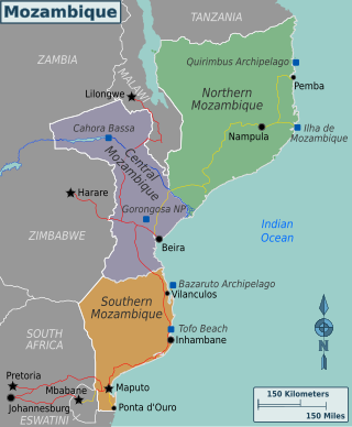
Mozambique, officially the Republic of Mozambique, is a country located in southeast Africa bordered by the Indian Ocean to the east, Tanzania to the north, Malawi and Zambia to the northwest, Zimbabwe to the west, and Eswatini and South Africa to the southwest. The sovereign state is separated from the Comoros, Mayotte and Madagascar by the Mozambique Channel to the east. The capital and largest city is Maputo.
Nampula is a province of northern Mozambique. It has an area of 79,010 km2 (30,510 sq mi) and a population of 5,758,920, making it the most populous province in Mozambique. Nampula is the capital of the province.

Meedhoo is one of the inhabited islands of Dhaalu Atoll.

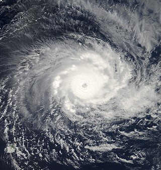
Intense Tropical Cyclone Leon–Eline was the second longest-lived cyclone in the Indian Ocean, behind Cyclone Freddy, traveling over 11,000 km (6,800 mi) during its 29-day track through the Indian Ocean, throughout the month of February. The cyclone formed on 1 February 2000, in the Australian basin as Tropical Cyclone Leon, and was renamed Eline after crossing 90° E into the South-West Indian Ocean; there, the Météo-France office in Réunion (MFR) tracked the storm's movement and intensity. Late on 17 February, Eline made landfall near Mahanoro, Madagascar, with 10‑minute winds of 165 km/h (103 mph). The storm rapidly weakened over land, but restrengthened in the Mozambique Channel to reach peak 10‑minute winds of 185 km/h (115 mph), making it an intense tropical cyclone. On 22 February, Eline made landfall about 80 km (50 mi) south of Beira, Mozambique, near peak intensity. Eline quickly weakened over land as it moved across Southern Africa, finally dissipating over eastern Namibia on 29 February.
Serena Hotels is a hospitality company which operates up-scale hotels and resorts in East Africa, Southern Africa and South Asia.
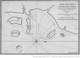
Indigo Bay Lodge Airport is an airport serving the former Indigo Bay Lodge on Bazaruto Island, Mozambique. The current facility is the Anantara Bazaruto Island Resort. The private facility has an airstrip and a helipad.
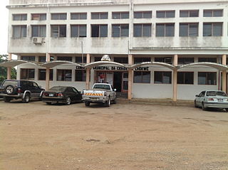
Chokwé, and earlier known as Vila Trigo de Morais, is a rural town and capital of Chokwe District in the province of Gaza in Mozambique. It is located about 230 kilometres (140 mi) north of the capital city of Maputo. This agricultural town is noted for its tomatoes.

Pestana Group is a Portuguese tourism and leisure group. Its hotel chain Pestana Hotels and Resorts has 100 hotels with over 12,000 rooms. The group manages Pousadas de Portugal since 2003.

The 2006–07 South-West Indian Ocean cyclone season featured the second-most intense tropical cyclones for a season in the tropical cyclone basin, only behind the 2018–19 season. The basin contains the waters of the Indian Ocean south of the equator and west of 90°E. Météo-France's meteorological office in Réunion (MFR), the official Regional Specialized Meteorological Center for the South-West Indian Ocean, tracked 15 tropical disturbances, of which eleven attained gale-force winds. The season began in October 2006 with a short-lived tropical disturbance, followed by Anita in November, which was the first named storm of the season. Cyclone Bondo was the first of six intense tropical cyclones, which took a rare track through the southern Seychelles before making landfall on northwest Madagascar, killing 11 people. Severe Tropical Storm Clovis lasted from December 2006 to January 2007; it struck eastern Madagascar, killing four people.
Clarisse Machanguana is a professional women's basketball player and philanthropist from Mozambique. She has played internationally in both the United States and in Spain. She also represented Mozambique at the 2006 Lusophony Games in Macau, China. In 2014 founded the Clarisse Machanguana Foundation, which empowers Mozambiquan youth through sport, education and health. Machanguana was the UNICEF ambassador to Mozambique from 2016 to 2018.

Inhassoro District is a district of Inhambane Province in south-east Mozambique. The district is located at the northeast of the province, and borders with Govuro District in the north, Vilanculos District in the southeast, Massinga District in the south, Funhalouro District in the southwest, and with Mabote District in the west. In the east, the district is bounded by the Indian Ocean. The area of the district is 4,480 square kilometres (1,730 sq mi). It has a population of 48,537 as of 2007.

Chókwè District is a district of Gaza Province in south-western Mozambique. Its principal town is Chokwe. The district is located in the south of the province, and borders with Mabalane District in the north, Guijá District in the east, Chibuto, Xai-Xai, and Bilene Macia Districts in the southeast, Magude District of Maputo Province in the south, and with Massingir District in the west. The area of the district is 2,466 square kilometres (952 sq mi). It has a population of 187,422 (2007).

Macomia District is a district of Cabo Delgado Province in northern Mozambique. It covers 4,252 km² with 91,033 inhabitants.

Benguerra Island in Mozambique is the second largest island in the Bazaruto Archipelago, which broke away from the mainland thousands of years ago. The island is approximately 55 square kilometers, and lies 14km offshore. Portuguese explorers also gave the island the name Santo António. It is famous for its unspoiled white beaches, dive sites, luxury resorts, horseback riding and fishing.
Water supply and sanitation in Mozambique is characterized by low levels of access to at least basic water sources, low levels of access to at least basic sanitation and mostly poor service quality. In 2007 the government has defined a strategy for water supply and sanitation in rural areas, where 62% of the population lives. In urban areas, water is supplied by informal small-scale providers and by formal providers.
Mozambique is a country particularly hard-hit by the HIV/AIDS epidemic. According to 2008 UNAIDS estimates, this southeast African nation has the 8th highest HIV rate in the world. With 1,600,000 Mozambicans living with HIV, 990,000 of which are women and children, Mozambique's government realizes that much work must be done to eradicate this infectious disease. To reduce HIV/AIDS within the country, Mozambique has partnered with numerous global organizations to provide its citizens with augmented access to antiretroviral therapy and prevention techniques, such as condom use. A surge toward the treatment and prevention of HIV/AIDS in women and children has additionally aided in Mozambique's aim to fulfill its Millennium Development Goals (MDGs). Nevertheless, HIV/AIDS has made a drastic impact on Mozambique; individual risk behaviors are still greatly influenced by social norms, and much still needs to be done to address the epidemic and provide care and treatment to those in need.
Prostitution in Madagascar is legal, and common, especially in tourist areas. Related activities such as soliciting, procuring, living off the earnings of prostitution or keeping a brothel are prohibited. Public Order laws are also used against prostitutes. There are recent laws against "consorting with female prostitutes". People caught paying for sex with children under 14 can face criminal penalties of up to 10 years imprisonment. This is strictly enforced against foreign tourists. As well as in the tourist areas, prostitution also occurs around the mining towns of the interior such as Ilakaka and Andilamena. It was estimated that there were 167,443 sex workers in the country in 2014.
Very Intense Tropical Cyclone Hudah was a powerful and destructive tropical cyclone that affected Southeast Africa in April 2000. It was the last in a series of three cyclones that impacted Madagascar during the year. Hudah first developed as a disturbance embedded within the monsoon trough on 22 March, within the Australian region cyclone basin. Moving westward as the result of a strong subtropical ridge to its south, the storm quickly intensified, and reached Category 2 cyclone intensity on 25 March before entering the Southwest Indian cyclone basin. For various reasons that remain unknown, the cyclone was only designated a name by the time it had crossed into the area of responsibility of the Regional Specialized Meteorological Center in Réunion. Nonetheless, Météo-France (MFR) assigned the name Hudah to the cyclone. An eye formed, and the storm intensified into a tropical cyclone on 27 March well to the southeast of Diego Garcia. On 1 April, the MFR upgraded it to a very intense tropical cyclone, estimating peak 10-minute winds of 225 km/h (140 mph). By contrast, the Joint Typhoon Warning Center (JTWC) estimated 1-minute winds of 235 km/h (146 mph). At this time, the MFR estimated the pressure to have been 905 hPa (mbar), making Hudah the most intense tropical cyclone worldwide in 2000. Cyclone Hudah maintained peak winds until making landfall just southeast of Antalaha, Madagascar on 2 April. It weakened greatly over land, but re-attained tropical cyclone status on 5 April after moving over the Mozambique Channel. Hudah reached 10-minute winds of 160 km/h (99 mph) by the time it made landfall on Mozambique near Pebane, Mozambique, on 8 April, and dissipated by the next day.
Chiaquelane is a village and camp for persons displaced by flooding, located about 30 km from the city of Chókwè, Gaza Province, Mozambique.
Vamizi Island is situated in the far north of Mozambique in the Quirimbas Archipelago. The island is recognised as one of the leading luxury private islands and conservation projects in East Africa and the Indian Ocean.