Basantapur is a Village Development Committee in Baitadi District in Sudurpashchim Province of western Nepal. At the time of the 1991 Nepal census it had a population of 2,141 and had 366 houses in the village.
Chyangli is a village development committee in Gorkha District in the Gandaki Zone of northern-central Nepal. At the time of the 1991 Nepal census it had a population of 5,612 and had 1066 houses in the town.
Lakshminibas is a village development committee in Dhanusa District in the Janakpur Zone of south-eastern Nepal. At the time of the 1991 Nepal census it had a population of 2,656 persons living in 459 individual households.
Shantidanda is a town and Village Development Committee in Ilam District in the Province No. 1 of eastern Nepal. At the time of the 1991 Nepal census it had a population of 4,373 persons living in 794 individual households.
Chapakot is a village and Village Development Committee in Kaski District in the Gandaki Zone of northern-central Nepal. At the time of the 1991 Nepal census it had a population of 2,966 persons residing in 574 individual households.
Girichauka is a village development committee in Doti District in the Seti Zone of western Nepal. At the time of the 1991 Nepal census it had a population of 3320 living in 616 individual households.
Chande is a village development committee in Salyan District in the Rapti Zone of western-central Nepal. At the time of the 1991 Nepal census it had a population of 4096 people living in 620 individual households.
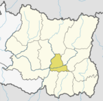
Kotmala is a village development committee in Salyan District in the Rapti Zone of western-central Nepal. At the time of the 1991 Nepal census it had a population of 3735 people living in 649 individual households.
Govindapur Malahanama is a village development committee in Siraha District in the Sagarmatha Zone of south-eastern Nepal. At the time of the 1991 Nepal census it had a population of 6758.
Sothayan is a village development committee in Siraha District in the Sagarmatha Zone of south-eastern Nepal. At the time of the 1991 Nepal census it had a population of 3004 people living in 539 individual households.

Olangchung Gola is a village in ward no. 7 of Phaktanglung rural municipality of Taplejung District of Province No. 1 in Nepal. Olangchung is surrounded by Lelep village to the east and Tibet to the north, Sankhuwasabha District to west and Mikkwakhola rural municipality to south. It is located to the north of Tamor River in the mountainous area in the northwest of Taplejung District bordering Tibet, China. Lately the river flowing next to the village is gradually expanding towards the village posing a serious threat of submerging the village.
Inarwa is a village development committee in Saptari District in the Sagarmatha Zone of south-eastern Nepal. At the time of the 1991 Nepal census it had a population of 2582 people living in 416 individual households.
Rampura Malhaniya is a village development committee in Saptari District in the Sagarmatha Zone of south-eastern Nepal. At the time of the 1991 Nepal census it had a population of 4728 people living in 835 individual households.

Raja Rani is a village development committee in Dhankuta District in the Koshi Zone of eastern Nepal. At the time of the 1991 Nepal census it had a population of 2567 people living in 491 individual households.
Gharti Gaun is a village development committee in Rolpa District in the Rapti Zone of north-eastern Nepal. At the time of the 1991 Nepal census it had a population of 4105 people living in 734 individual households.
Rangsi is a village development committee in Rolpa District in the Rapti Zone of north-eastern Nepal. At the time of the 1991 Nepal census it had a population of 4000 people living in 745 individual households.
Deurali is a village development committee in Palpa District in the Lumbini Zone of southern Nepal. At the time of the 1991 Nepal census it had a population of 2637 people living in 515 individual households.
Kushawa is a village development committee in Kapilvastu District in the Lumbini Zone of southern Nepal. At the time of the 1991 Nepal census it had a population of 3586 people living in 578 individual households.
Pipari is a village development committee in Kapilvastu District (Kapilbastu) in the Lumbini Zone of southern Nepal. At the time of the 1991 Nepal census it had a population of 1872 people living in 303 individual households.
Sorabhag is a village development committee in Morang District in the Kosi Zone of south-eastern Nepal. At the time of the 1991 Nepal census it had a population of 7865 people living in 1605 individual households. Popular market called KARSIYA lies here. Rangeli raid passes through it.