Related Research Articles

Satellite temperature measurements are inferences of the temperature of the atmosphere at various altitudes as well as sea and land surface temperatures obtained from radiometric measurements by satellites. These measurements can be used to locate weather fronts, monitor the El Niño-Southern Oscillation, determine the strength of tropical cyclones, study urban heat islands and monitor the global climate. Wildfires, volcanos, and industrial hot spots can also be found via thermal imaging from weather satellites.

Remote sensing is the acquisition of information about an object or phenomenon without making physical contact with the object, in contrast to in situ or on-site observation. The term is applied especially to acquiring information about Earth and other planets. Remote sensing is used in numerous fields, including geophysics, geography, land surveying and most Earth science disciplines. It also has military, intelligence, commercial, economic, planning, and humanitarian applications, among others.
Ground truth is information that is known to be real or true, provided by direct observation and measurement as opposed to information provided by inference.
SeaWiFS was a satellite-borne sensor designed to collect global ocean biological data. Active from September 1997 to December 2010, its primary mission was to quantify chlorophyll produced by marine phytoplankton.

Multispectral imaging captures image data within specific wavelength ranges across the electromagnetic spectrum. The wavelengths may be separated by filters or detected with the use of instruments that are sensitive to particular wavelengths, including light from frequencies beyond the visible light range. It can allow extraction of additional information the human eye fails to capture with its visible receptors for red, green and blue. It was originally developed for military target identification and reconnaissance. Early space-based imaging platforms incorporated multispectral imaging technology to map details of the Earth related to coastal boundaries, vegetation, and landforms. Multispectral imaging has also found use in document and painting analysis.

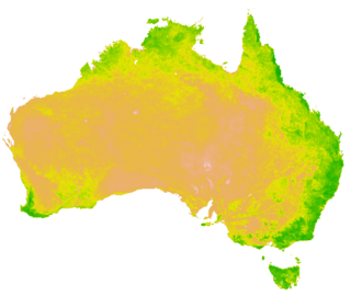
The normalized difference vegetation index (NDVI) is a widely-used metric for quantifying the health and density of vegetation using sensor data. It is calculated from spectrometric data at two specific bands: red and near-infrared. The spectrometric data is usually sourced from remote sensors, such as satellites.

Interferometric synthetic aperture radar, abbreviated InSAR, is a radar technique used in geodesy and remote sensing. This geodetic method uses two or more synthetic aperture radar (SAR) images to generate maps of surface deformation or digital elevation, using differences in the phase of the waves returning to the satellite or aircraft. The technique can potentially measure millimetre-scale changes in deformation over spans of days to years. It has applications for geophysical monitoring of natural hazards, for example earthquakes, volcanoes and landslides, and in structural engineering, in particular monitoring of subsidence and structural stability.
Atmospheric correction is the process of removing the scattering and absorption effects of the atmosphere on the reflectance values of images taken by satellite or airborne sensors. Atmospheric effects in optical remote sensing are significant and complex, dramatically altering the spectral nature of the radiation reaching the remote sensor. The atmosphere both absorbs and scatters various wavelengths of the visible spectrum which must pass through the atmosphere twice, once from the sun to the object and then again as it travels back up the image sensor. These distortions are corrected using various approaches and techniques, as described below.
The Advanced Along Track Scanning Radiometer (AATSR) is one of the Announcement of Opportunity (AO) instruments on board the European Space Agency (ESA)'s Envisat satellite.

The Operational Land Imager (OLI) is a remote sensing instrument aboard Landsat 8, built by Ball Aerospace & Technologies. Landsat 8 is the successor to Landsat 7 and was launched on February 11, 2013.
Multispectral remote sensing is the collection and analysis of reflected, emitted, or back-scattered energy from an object or an area of interest in multiple bands of regions of the electromagnetic spectrum. Subcategories of multispectral remote sensing include hyperspectral, in which hundreds of bands are collected and analyzed, and ultraspectral remote sensing where many hundreds of bands are used. The main purpose of multispectral imaging is the potential to classify the image using multispectral classification. This is a much faster method of image analysis than is possible by human interpretation.
Collocation is a procedure used in remote sensing to match measurements from two or more different instruments. This is done for two main reasons: for validation purposes when comparing measurements of the same variable, and to relate measurements of two different variables either for performing retrievals or for prediction. In the second case the data is later fed into some type of statistical inverse method such as an artificial neural network, statistical classification algorithm, kernel estimator or a linear least squares. In principle, most collocation problems can be solved by a nearest neighbor search, but in practice there are many other considerations involved and the best method is highly specific to the particular matching of instruments. Here we deal with some of the most important considerations along with specific examples.

Ecosystem Functional Type (EFT) is an ecological concept to characterize ecosystem functioning. Ecosystem Functional Types are defined as groups of ecosystems or patches of the land surface that share similar dynamics of matter and energy exchanges between the biota and the physical environment. The EFT concept is analogous to the Plant Functional Types (PFTs) concept, but defined at a higher level of the biological organization. As plant species can be grouped according to common functional characteristics, ecosystems can be grouped according to their common functional behavior.
Normalized Difference Water Index (NDWI) may refer to one of at least two remote sensing-derived indexes related to liquid water:
A vegetation index (VI) is a spectral imaging transformation of two or more image bands designed to enhance the contribution of vegetation properties and allow reliable spatial and temporal inter-comparisons of terrestrial photosynthetic activity and canopy structural variations.

Remote sensing is used in the geological sciences as a data acquisition method complementary to field observation, because it allows mapping of geological characteristics of regions without physical contact with the areas being explored. About one-fourth of the Earth's total surface area is exposed land where information is ready to be extracted from detailed earth observation via remote sensing. Remote sensing is conducted via detection of electromagnetic radiation by sensors. The radiation can be naturally sourced, or produced by machines and reflected off of the Earth surface. The electromagnetic radiation acts as an information carrier for two main variables. First, the intensities of reflectance at different wavelengths are detected, and plotted on a spectral reflectance curve. This spectral fingerprint is governed by the physio-chemical properties of the surface of the target object and therefore helps mineral identification and hence geological mapping, for example by hyperspectral imaging. Second, the two-way travel time of radiation from and back to the sensor can calculate the distance in active remote sensing systems, for example, Interferometric synthetic-aperture radar. This helps geomorphological studies of ground motion, and thus can illuminate deformations associated with landslides, earthquakes, etc.

The moment distance index (MDI) is a shape-based metric or shape index that can be used to analyze spectral reflectance curves and waveform LiDAR, proposed by Dr. Eric Ariel L. Salas and Dr. Geoffrey M. Henebry. In the case of spectral data, the shape of the reflectance curve should unmask fine points of the spectra usually not considered by existing band-specific indices. It has been used to identify spectral regions for chlorophyll and carotenoids, detect greenhouses using WorldView-2, Landsat, and Sentinel-2 satellite data, identify greenhouse crops, compute canopy heights, estimate green vegetation fraction, and optimize Fourier-transform infrared (FTIR) scans for soil spectroscopy.
Land cover maps are tools that provide vital information about the Earth's land use and cover patterns. They aid policy development, urban planning, and forest and agricultural monitoring.
Remote sensing in oceanography is a widely used observational technique which enables researchers to acquire data of a location without physically measuring at that location. Remote sensing in oceanography mostly refers to measuring properties of the ocean surface with sensors on satellites or planes, which compose an image of captured electromagnetic radiation. A remote sensing instrument can either receive radiation from the Earth’s surface (passive), whether reflected from the Sun or emitted, or send out radiation to the surface and catch the reflection (active). All remote sensing instruments carry a sensor to capture the intensity of the radiation at specific wavelength windows, to retrieve a spectral signature for every location. The physical and chemical state of the surface determines the emissivity and reflectance for all bands in the electromagnetic spectrum, linking the measurements to physical properties of the surface. Unlike passive instruments, active remote sensing instruments also measure the two-way travel time of the signal; which is used to calculate the distance between the sensor and the imaged surface. Remote sensing satellites often carry other instruments which keep track of their location and measure atmospheric conditions.

Thermal remote sensing is a branch of remote sensing in the thermal infrared region of the electromagnetic spectrum. Thermal radiation from ground objects is measured using a thermal band in satellite sensors.
References
- ↑ Holben, Brent (1986). "Characteristics of maximum-value composite images from temporal AVHRR data". International Journal of Remote Sensing. 7 (11): 1417–1434. Bibcode:1986IJRS....7.1417H. doi: 10.1080/01431168608948945 .
- ↑ Taddei, R (1997). "Maximum Value Interpolated (MVI): A Maximum Value Composite method improvement in vegetation index profiles analysis". International Journal of Remote Sensing. 18 (11): 2365–2370. Bibcode:1997IJRS...18.2365T. doi:10.1080/014311697217657.
| | This meteorology–related article is a stub. You can help Wikipedia by expanding it. |
| | This remote sensing-related article is a stub. You can help Wikipedia by expanding it. |