Maya Center

Last updated

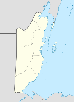
Maya Center is a village in the Stann Creek District of Belize. It is located on the road to the Cockscomb Basin Wildlife Sanctuary. According to the 2010 census, Maya Center has a population of 386 people in 87 households. [1]
Related Research Articles

<span class="mw-page-title-main">Belize</span> Country in Central America

Belize is a Caribbean and Central American country on the north-eastern coast of Central America. It is bordered by Mexico to the north, the Caribbean Sea to the east, and Guatemala to the west and south. It also shares a water boundary with Honduras to the southeast. It has an area of 22,970 square kilometres (8,867 sq mi) and a population of 441,471 (2022). Its mainland is about 290 km (180 mi) long and 110 km (68 mi) wide. It is the least populated and least densely populated country in Central America. Its population growth rate of 1.87% per year is the second-highest in the region and one of the highest in the Western Hemisphere. Its capital is Belmopan, and its largest city is the namesake city of Belize City. Belize is often thought of as a Caribbean country in Central America because it has a history similar to that of English-speaking Caribbean nations. Indeed, Belize's institutions and official language reflect its history as a British colony.

<span class="mw-page-title-main">Demographics of Belize</span> Demographics of country

This article is a demography of the population of Belize including population density, ethnicity, education level, health of the populace, economic status, religious affiliations and other aspects of the population.

<span class="mw-page-title-main">Corozal Town</span> Town in Corozal, Belize

Corozal Town is a town in Belize, capital of Corozal District. Corozal Town is located about 84 miles north of Belize City, and 9 miles from the border with Mexico. The population of Corozal Town, according to the main results of the 2010 census, is 9,871.

<span class="mw-page-title-main">Benque Viejo del Carmen</span> Town in Cayo District, Belize

Benque Viejo del Carmen ("Benque") is the westernmost town in Belize, 130 km (81 mi) by road west and south of Belize City, at the Guatemalan border. San Ignacio lies 13 km to the east and Melchor de Mencos just across the border. The Mopan River runs along the town's north and west edges.

<span class="mw-page-title-main">Stann Creek District</span> District of Belize

Stann Creek District is a district in the south east region of Belize. According to the 2010 census, the district had a population of 32,166 people. Its capital is the town of Dangriga, formerly known as "Stann Creek Town." Stann comes from "stanns," or safe havens used by colonialists coming from the "old world" to the "new world."

<span class="mw-page-title-main">Toledo District</span> District of Belize

Toledo District is the southernmost district in Belize, and Punta Gorda is the District capital. It is the second most developed region in the country. The district has a diverse topography which features rainforests, extensive cave networks, coastal lowland plains, and offshore cays. Toledo is home to a wide range of cultures such as: Mopan and Kekchi Maya, Creole, the Garifuna, East Indians, Mennonites, Mestizos, and descendants of US Confederate settlers.

<span class="mw-page-title-main">Orange Walk District</span> Northwestern district of Belize

Orange Walk District is a district in the northwest of the nation of Belize, with its district capital in Orange Walk Town.

<span class="mw-page-title-main">Carmelita, Belize</span> Place in Orange Walk District, Belize

Carmelita is a rapidly-expanding village in the Orange Walk District of the nation of Belize. According to the 2010 census, it had a population of 1,474 people. It lies along the New River. Carmelita has the country's only toll booth at the New River bridge on the Northern Highway where the village begins. Beside the bridge lies an access point for boat tours to the Maya historic site, Lamanai.

Louisville is a village in the Corozal District of the nation of Belize, located at 18°19′N88°30′W. According to the 2000 census, it had a population of 655 people mainly from Maya Mestizo ancestry.

<span class="mw-page-title-main">Patchakán</span> Place in Corozal District, Belize

Patchakán is a town in Corozal District, in northern Belize. According to the 2000 census, it had a population of 1,142 people mainly of the Yucatec Maya ethnicity. The name Patchacan means "behind the shavanna" in Yucatec Maya.

Chunox is a village in the Corozal District of the nation of Belize. Chunox is located on the east bank of Laguna Seca towards the south end of the lagoon at an altitude of 3 meters above sea level. According to the 2000 census, Chunox had a population of 1,143 people.

<span class="mw-page-title-main">Chetumal</span> Place in Quintana Roo, Mexico

Chetumal is a city on the east coast of the Yucatán Peninsula in Mexico. It is the capital of the state of Quintana Roo and the municipal seat of the Municipality of Othón P. Blanco. In 2020 it had a population of 169,028 people.

<span class="mw-page-title-main">Placencia</span> Village in Stann Creek, Belize

Placencia is a small village located in the Stann Creek District of Belize.

<span class="mw-page-title-main">Indian Church, Belize</span> Place in Orange Walk District, Belize

Indian Church is a small remote village in the Orange Walk District of Belize. It is located on the west bank of New River, neighbouring the town of San Carlos to its south, and the Maya ruins of Lamanai to its north. According to the 2010 census, Indian Church has a population of 267 people in 66 households. The village is named for the historic Spanish churches recovered among the ancient Maya ruins. The residents lived among the ruins until 1991 when the Government of Belize established the 2-square-mile (5.2 km2) Lamanai Archaeological Reserve maintained by Belize's Institute of Archaeology.

<span class="mw-page-title-main">Xnaheb</span> Archaeological site in Belize

Xnaheb is an archaeological site of the pre-Columbian Maya civilization, one of five primary sites identified in the southern Belize region. The center is built on a ridge of foothills that extends from the Maya Mountains, in what is now the Toledo District of Belize. Based on certain architectural similarities between the two sites, it is possible that Xnaheb was founded as an offshoot of Nim Li Punit.

Chan Chen is a village located in Corozal District, Belize. Most of the inhabitants speak Spanish or Yucatec Maya, along with some English. The name Chan Chen is Yucatec maya meaning "small well" in English. Most Chan Chen inhabitants are of Maya ancestry.

<span class="mw-page-title-main">Maritime trade in the Maya civilization</span>

The extensive trade networks of the Ancient Maya contributed largely to the success of their civilization spanning three millennia. Maya royal control and the wide distribution of foreign and domestic commodities for both population sustenance and social affluence are hallmarks of the Maya visible throughout much of the iconography found in the archaeological record. In particular, moderately long-distance trade of foreign commodities from the Caribbean and Gulf Coasts provided the larger inland Maya cities with the resources they needed to sustain settled population levels in the several thousands. Though the ruling class essentially controlled the trade economy, a middle merchant class supervised import and export from cities and trade ports. Not much is known of the Maya merchant class; however, merchants of royal lineage are sometimes represented in the iconography. Notably, a canoe paddle often accompanies the royal merchant depictions, signifying their association with marine resources.


Douglas is a village situated by the Rio Hondo river in Orange Walk District, Belize, 12 miles from Orange Walk Town. According to the 2010 census, there were 122 households in Douglas with a population of 521 people, 270 males and 250 females consisting mostly from people of Maya Mestizo descent.

Yo Creek is a small village located in the Orange Walk District of the nation of Belize, consisting mainly of people of Yucatec Maya descent. The name Yo Creek comes from the combination of the Maya word yo which means "top" and the English word creek. Most Yo Creek residents speak Spanish and English very well, while the elders still speak their Maya language. Yo Creek is well known for cultural programs to preserve the Maya Yucatec culture. The village is also known for their Poktapok Maya ball game team Ek' Balam which means in the Yucatec Maya language Black Jaguars who won the championship in El Mundo Maya mundial de PoktaPok 2017.

Maya Beach Village is a village in the Stann Creek District of Belize located on the Placencia Peninsula, between Riversdale Village and Seine Bight. Based on the 2010 national census, Maya Beach has a population of 225 year round residents. The village is home to a number of resorts, boutique hotels, and vacation homes. Notable resorts include Maya Beach Hotel Bistro, Belize Ocean Club, and Naia Resort & Spa. The village is often considered a part of the peninsula's largest community and namesake, Placencia, which is a short drive from the village. Maya Beach is served by the Placencia Airport, with the closest international hub being Philip S. W. Goldson International Airport in Belize City.

References

  1. "Belize Population and Housing Census: 2010 Country Report" (PDF). Statistical Institute of Belize. Archived from the original (PDF) on 27 January 2016. Retrieved 25 July 2015.

Coordinates: 16°47′54″N88°22′57″W / 16.7983°N 88.3826°W / 16.7983; -88.3826