
Tobago is an island within the Republic of Trinidad and Tobago. It is located 35 kilometres (22 mi) northeast of the mainland of Trinidad and southeast of Grenada, about 160 kilometres (99 mi) off the coast of northeast Venezuela. According to the earliest English-language source cited in the Oxford English Dictionary, Tobago bore a name that has become the English word tobacco. The official bird of Tobago is the cocrico.
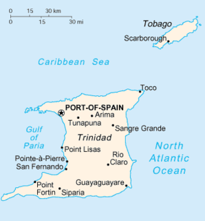
Trinidad is the larger and more populous of the two major islands of Trinidad and Tobago. The island lies 11 km (6.8 mi) off the northeastern coast of Venezuela and sits on the continental shelf of South America. It is often referred to as the southernmost island in the Caribbean. With an area of 4,768 km2 (1,841 sq mi), it is also the fifth largest in the West Indies.

Scarborough is a city and the capital of the Island of Tobago as well as the eleventh-most-populous in Trinidad and Tobago. Scarborough became the capital of Tobago in 1769. Situated in western Tobago, Scarborough is the economic and cultural centre of the island of Tobago. The estimated population in 2011 was 17,537. Scarborough is ranked as one of Trinidad and Tobago's most densely populated towns alongside Port of Spain, San Fernando, Chaguanas and Arima. The city's skyline is dominated by Fort King George, an 18th-century fortification named after King George III, which now hosts a historic and archaeologic museum. Scarborough's deepwater harbour was built in 1991; before that ships were forced to anchor offshore.
San Fernando, officially the City of San Fernando, is the second most populous municipality in Trinidad and Tobago, after Chaguanas and the most populous city. It occupies 19 km² and is located in the southwestern part of the island of Trinidad. It is bounded to the north by the Guaracara River, the south by the Oropouche River, the east by the Sir Solomon Hochoy Highway, and the west by the Gulf of Paria. The former borough was elevated to the status of a city corporation on 18 November 1989. The motto of San Fernando is: "Sanitas Fortis" - In a Healthy Environment We Will Find Strength. Many local Trinidadians refer to the city with the shortened name "Sando." San Fernando is called Trinidad and Tobago's "industrial capital" because of its proximity to the Pointe-à-Pierre oil refinery and many other petrochemical, LNG, iron and steel and aluminium smelters in places such as Point Lisas in Couva, Point Fortin, and La Brea.

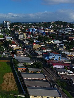
Arima, officially The Royal Chartered Borough of Arima is the easternmost and second largest in area of the three boroughs of Trinidad and Tobago. It is geographically adjacent to Sangre Grande and Arouca at the southcentral foothills of the Northern Range. To the south is the Caroni–Arena Dam. Coterminous with Town of Arima since 1888, the borough of Arima is the fourth-largest municipality in population in the country. The census estimated it had 33,606 residents in 2011.

Point Fortin, officially the Republic Borough of Point Fortin, the smallest Borough in Trinidad and Tobago is located in southwestern Trinidad, about 32 km (20 mi) southwest of San Fernando, in the historic county of Saint Patrick. After the discovery of petroleum in the area in 1906 the town grew into a major oil-producing centre. The town grew with the oil industry between the 1940s and 1980s, culminating in its elevation to borough status in 1980. After the end of the oil boom Point Fortin was hit hard by economic recession in the 1980s and the closure of its oil refinery. Construction of a Liquefied Natural Gas plant by Atlantic LNG in late 1990s boosted the economy.

Mayaro is the name of a county on southeastern Trinidad island, in Trinidad and Tobago.
Princes Town is a town within the Princes Town Regional Corporation, located on southern Trinidad island in Trinidad and Tobago. The population of the town is 28,335.

Diego Martin is a town and is the urban commercial center and capital of the Diego Martin region in Trinidad and Tobago. Its location in the region is just on the south eastern border, west of the capital city of Port of Spain and east of the town of Carenage. Diego Martin town in the Northern Range was once filled with a number of small valleys but is now a densely populated area. It was named after a Spanish explorer Don Diego Martín. The area was settled by French planters and their slaves in the 1780s. It consists of a cluster of communities including Congo Village, Diamond Vale, Green Hill, Patna Village, Petit Valley, Blue Range, La Puerta Avenue, Four Roads, Rich Plain, River Estate, Blue Basin, Water Wheel, West Moorings, Bagatelle and Sierra Leone.
Gasparillo is a town in southern Trinidad. It lies east of Pointe-à-Pierre and northeast of San Fernando. The population is 16,426. The name Gasparillo is applied not only to Gasparillo area, but also the surrounding communities including Bonne Aventure, Reform and Whiteland. Trinidadians do not use Spanish sounds when saying Gasparillo. Correct local pronunciation is "gas-PARR-ri-low." Gasparillo is administrated by Couva–Tabaquite–Talparo Regional Corporation and Princes Town Regional Corporation.
Nariva is a county in Trinidad and Tobago. It is located in eastern Trinidad, south of Saint Andrew County and north of Mayaro County, to the west by Victoria County and to the northwest by Saint George County. The southern boundary of the county lies along the Ortoire River and the western boundary is Cocos Bay. The towns of Rio Claro and Ecclesville are located in Nariva County. The Nariva Swamp is located in the eastern part of Nariva County.

The Republic of Trinidad and Tobago is the southernmost island country in the Caribbean. Consisting of the main islands Trinidad and Tobago, and numerous much smaller islands, it is situated 130 kilometres south of Grenada and 11 kilometres off the coast of northeastern Venezuela. It shares maritime boundaries with Barbados to the northeast, Grenada to the northwest, Guyana to the southeast, and Venezuela to the south and west.
Television in Trinidad and Tobago was introduced in 1962 beginning with Trinidad & Tobago Television. TTT was the sole television station for 29 years being operated by the state until the first independently operated television station, the Caribbean Communications Network, CCN TV6 was launched in 1991 breaking the television monopoly market. In 1992, a second independently operated station, AVM Television was launched. The first independently operated cable station, The Trinity Network (TTN) now Trinity TV began operations in 1993 broadcasting on weekends only.

Mayaro–Rio Claro is a region of Trinidad. The local government body is Mayaro–Rio Claro Regional Corporation, a Regional Corporation of Trinidad and Tobago. The region has a land area of 852.81 km². The Mayaro–Rio Claro Regional Corporation is headquartered in Rio Claro. Other towns include Mayaro. The region possesses many beach front properties and Trinidad's largest reservoir of natural gas and crude oil along its eastern coast.
Cleopatra Borel is a female shot putter from Plaisance, Mayaro, Trinidad and Tobago and a 2014 Sportswoman of the Year Award recipient.
Valencia is a town located in northeastern Trinidad island, in the Republic of Trinidad and Tobago.

A general election was held in Trinidad and Tobago on May 24, 2010. The date of the general elections was announced by Prime Minister Patrick Manning on April 16, 2010, via a press release. The election was called over two years earlier than required by law. Polls showing that the UNC-led opposition coalition was likely to win the election were confirmed by the subsequent results.

Mayaro Bay stretches for nine miles on the east coast of the island of the Republic of Trinidad and Tobago. The beach which lines the bay, Mayaro Beach, is a popular destination for holidays, long weekends, and is one of the traditional places to spend the Easter holidays. Not only do beach-goers swim, but they also kayak, bird watch, camp, and occasionally kite surf, making Mayaro a tourist hot spot. Located at the southern end of Manzanilla Beach, Trinidad and Tobago, one can reach Mayaro Beach by traveling along the Mayaro–Guayaguayare road or the Mayaro–Naparima road.
In 2012, the government of Trinidad and Tobago approved the introduction of postal codes starting later that same year, but as of February 2018, the system is not yet in operation in some areas. It is currently launched in the Boroughs of Chaguanas, Point Fortin and Arima, Sangre Grande, Penal–Debe and Princes Town Regional Corporations and Tobago.

