Related Research Articles

Pushmataha County is a county in the southeastern part of the U.S. state of Oklahoma. As of the 2010 census, the population was 11,572. Its county seat is Antlers.

Choctaw County is a county located in the U.S. state of Oklahoma. As of the 2010 census, the population was 15,205. Its county seat is Hugo.

Boswell is a town in Choctaw County, Oklahoma, United States. The population was 709 at the 2010 census.

Tuskahoma is an unincorporated community and census-designated place in northern Pushmataha County, Oklahoma, United States, four miles east of Clayton. It was the former seat of the Choctaw Nation government prior to Oklahoma statehood. The population at the 2010 census was 151.
Boggy Depot is a ghost town and Oklahoma State Park that was formerly a significant city in the Indian Territory. It grew as a vibrant and thriving town in present-day Atoka County, Oklahoma, United States, and became a major trading center on the Texas Road and the Butterfield Overland Mail route between Missouri and San Francisco. After the Civil War, when the MKT Railroad came through the area, it bypassed Boggy Depot and the town began a steady decline. It was soon replaced by Atoka as the chief city in the area. By the early 20th century, all that remained of the community was a sort of ghost town.

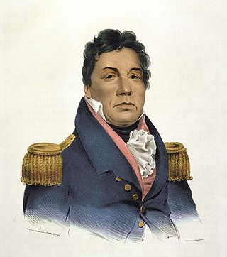
Allen Wright was Principal Chief of the Choctaw Republic from late 1866 to 1870. He had been ordained as a Presbyterian minister in 1852 after graduating from Union Theological Seminary in New York City. He was very active in the Choctaw government, holding several elected positions. He has been credited with the name Oklahoma for the land that would become the state.
Muddy Boggy Creek, also known as the Muddy Boggy River, is a 175-mile-long (282 km) river in south central Oklahoma. The stream headwaters arise just east of Ada in Pontotoc County. It is a major tributary of the Red River in south central Oklahoma. Clear Boggy Creek is a major tributary which enters the Muddy Boggy at a location known as River Mile 24 in Choctaw County. The river is inhabited by over one hundred species of fish.
Corinne is an unincorporated community in southern Pushmataha County, Oklahoma, United States, located 19 miles east of Antlers. Using the Public Land Survey System commonly in use in Oklahoma, the community is located in T22-4S-R19E.
Lyceum is a former academic community in northern Pushmataha County, Oklahoma, United States, located two miles west of Tuskahoma.
Zoraya, pronounced “Zoray”, is a ghost town in western Pushmataha County, Oklahoma, United States, west of Miller.
Kiamitia County, also known as Kiamichi County, was a political subdivision of the Choctaw Nation, Indian Territory. The county formed part of the nation's Pushmataha District, or Third District, one of three administrative super-regions.
Cedar County was a political subdivision of the Choctaw Nation in the Indian Territory. The county formed part of the nation’s Apukshunnubbee District, or Second District, one of three administrative super-regions.
Spencerville is an unincorporated community in northern Choctaw County, Oklahoma, United States. It is 12 miles northeast of Hugo, adjacent to the Pushmataha County border. The improved Ft. Smith to Ft. Towson military road of 1839 ran north–south through Spencerville after crossing the "Seven Devils" on its way southeast to Doaksville. This wagon road was heavily used by the U.S. Army from 1839 to 1848, especially during the war with Mexico.
Jack's Fork County, also known as Jack Fork County, was a political subdivision of the Choctaw Nation of Indian Territory. The county formed part of the nation's Pushmataha District, or Third District, one of three administrative super-regions.
Jackson County was a political subdivision of the Choctaw Nation of Indian Territory, prior to Oklahoma being admitted as a state. The county formed part of the Nation's Pushmataha District, or Third District, one of three administrative super-regions.
The Choctaw Capitol Building is a historic building built in 1884 that housed the government of the Choctaw Nation of Oklahoma from 1884 to 1907. The building is located in Pushmataha County, Oklahoma, two miles north of Tuskahoma. The site also includes the Choctaw Nation Council House and the Old Town Cemetery of Tuskahoma.
Pushmataha District was one of three provinces, or districts, comprising the former Choctaw Nation in the Indian Territory. Also called the Third District, it encompassed the southwestern one-third of the nation.
Wade County was a political subdivision of the Choctaw Nation of Indian Territory, prior to Oklahoma being admitted as a state. The county formed part of the Nation's Apukshunnubbee District, or First District, one of three administrative super-regions.
Cyrus Kingsbury was a Christian missionary active among the American Indians in the nineteenth century. He first worked with the Cherokee and founded Brainerd Mission near Chickamauga, Tennessee, later he served the Choctaw of Mississippi. He was known as "the Father of the Missions" in Indian Territory.

Atoka County was a political subdivision of the Choctaw Nation of Indian Territory, prior to Oklahoma being admitted as a state. The county formed part of the Nation's Pushmataha District, or Third District, one of three administrative super-regions.
References
- ↑ George H. Shirk, Oklahoma Place Names, p. 138.
- ↑ Shirk, Oklahoma Place Names, p. 27.
- ↑ Account of Jennie Selfridge, WPA worker, September 1936. The account appears in the Indian-Pioneer Papers held by the Western History Collections of the University of Oklahoma Libraries. An online copy is available at http://digital.libraries.ou.edu/whc/pioneer/papers/8089%20Selfridge.pdf.
- ↑ Cyrus Kingsbury Papers, Western History Collections, University of Oklahoma Libraries.