The Mangapps Railway Museum is a heritage railway centre located near Burnham-on-Crouch in Essex. The 0.75 miles (1.21 km) of standard gauge running line and museum are owned and operated by the Jolly family assisted by volunteers.

Kananga, formerly known as Luluabourg or Luluaburg, is the capital city of the Kasai-Central Province in the Democratic Republic of the Congo and was the capital of the former Kasaï-Occidental Province. The city has an estimated population of 1,463,556.
Iron ore production in Africa is dominated by South Africa, Mauritania and Algeria; Zimbabwe and Morocco produce ore for use within the country. Many countries possess iron ore deposits that are as yet untapped/unmined. Countries and companies currently involved in production are listed here; measurements are in tpy, or tonnes per year.

Kōdo Station is a train station located in Kyōtanabe, Kyoto, Japan. The station is served by Kintetsu Kyoto Line. It is one of the nearby stations of Kyotanabe Campus of Doshisha University.
Kongolo is a town in Tanganyika Province in the Democratic Republic of the Congo. It is located on the west bank of the Lualaba River, the largest headstream of the Congo River. It has 62,455 inhabitants.

Westend is a station in the Charlottenburg district of Berlin. It is located on the Ringbahn circle line, served by the S-Bahn lines S 41, S 42 and S 46. It is named after the Westend locality, which is immediately adjacent to the station grounds.
Railway stations in the Republic of the Congo (Congo) include:
Jean-Claude Siapa Ivouloungou was a Congolese politician. A member of the Pan-African Union for Social Democracy (UPADS), he was a Deputy in the National Assembly of the Republic of Congo from 2002 to 2012. When the Pan-African Parliament began meeting in March 2004, he became one of the Republic of Congo's five members.

Corby Glen railway station was a station on the Great Northern Railway main line serving Corby Glen, Lincolnshire. It was west of the village on the Melton Mowbray road, and was originally named just Corby, but was renamed to avoid confusion with Corby station on the Midland Railway in Northamptonshire. The station closed in 1959.
Ruvu is a small town and ward (shehia) located in the Kibaha District of the Pwani Region in eastern Tanzania, west of Dar es Salaam. As of 2002, the ward population was 6,697.

The Märkische Museum Railway or MME is a German railway society that was founded in order to show narrow gauge vehicles in operation on small branch lines.
Moutamba is a town in eastern Republic of Congo.

Lukula is a town in, and a territory of Kongo Central province, Democratic Republic of the Congo. It lies on the road and disused Mayumbe railway line between Boma, to the south, and Tshela, to the north, on the southern bank of the Lakula river. Lukula lies at an altitude of 646 ft above sea level. Economic activity includes cement production, utilising locally occurring limestone, and commercial Logging.
Nughu is an island in the Solomon Islands; it is located in Guadalcanal Province. The estimated terrain elevation above sea level is some 12 metres.
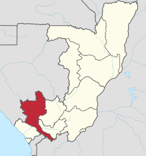
Titi is a town in western Congo. It is near the border with Gabon.

Oil and gas dominate the extraction industries of the Republic of the Congo, also referred to as Congo-Brazzaville. The petroleum industry accounted for 89% of the country’s exports in 2010. Among African crude oil producers in 2010, The Congo ranked seventh. Nearly all of the country's hydrocarbons were produced off-shore. The minerals sector is administered by the Department of Mines and Geology. Presently no major mining activities are underway, although there are some small-scale domestic operations. However, the country does have numerous large-scale undeveloped resources. The country has recently attracted a strong influx of international companies seeking to tap into the vast mineral wealth.