Mayoko | |
---|---|
District | |
![]() Mayoko District in the region | |
Country | ![]() |
Department | Niari Department |
Time zone | GMT +1 (UTC+1) |
Mayoko District is a district in the Niari Department of south-western Republic of the Congo. [1] The capital lies at Mayoko. It has a northern border with Gabon. As of 2007, the population is 5,147. [2]
The Departments of the Republic of the Congo are divided into 86 districts and 6 communes. Note the departments of Brazzaville and Pointe-Noire are made of 1 commune each, then divided in urban districts (arrondissements).
Niari is a department of the Republic of the Congo in the western part of the country. It borders the departments of Bouenza, Kouilou, and Lékoumou, and internationally, Gabon, the Democratic Republic of the Congo, and the Cabinda portion of Angola. The regional capital is Dolisie.
The Republic of the Congo, also known as Congo-Brazzaville, the Congo Republic, ROC or simply the Congo, is a country located in the western coast of Central Africa. It is bordered by five countries: Gabon to its west; Cameroon to its northwest and the Central African Republic to its northeast; the Democratic Republic of the Congo to the southeast and the Angolan exclave of Cabinda to its south; and the Atlantic Ocean to its southwest.
Mayoko is served by a branch railway of the Congo–Ocean Railway that terminates in Mbinda. It lies near the border with Gabon.
The Congo–Ocean Railway links the Atlantic port of Pointe-Noire with Brazzaville, a distance of 502 kilometres (312 mi). It bypasses the rapids on the lower Congo River; from Brazzaville, river boats are able to ascend the Congo River and its major tributaries, including the Oubangui River to Bangui.
Mbinda is a town in the Republic of Congo, lying on the border with Gabon. It is a transport hub and lies at the end of a railway line to Brazzaville.
Gabon, officially the Gabonese Republic, is a country on the west coast of Central Africa. Located on the equator, Gabon is bordered by Equatorial Guinea to the northwest, Cameroon to the north, the Republic of the Congo on the east and south, and the Gulf of Guinea to the west. It has an area of nearly 270,000 square kilometres (100,000 sq mi) and its population is estimated at 2 million people. Its capital and largest city is Libreville.
Mayoko is near deposits of iron ore, which are very close to an existing railway line leading to a port.
Railway stations in the Republic of the Congo (Congo) include:
Iron ore production in Africa is dominated by South Africa, Mauritania and Algeria; Zimbabwe and Morocco produce ore for use within the country. Many countries possess iron ore deposits that are as yet untapped/unmined. Countries and companies currently involved in production are listed here; measurements are in tpy, or tonnes per year.
Kayes is a small town in the Bouenza Department of the Republic of the Congo. It is located about 2 km south of Nkayi, the country’s fourth largest city. Kayes is also the name of a district, of which the town of Kayes is the capital.
Hinda is a district in the Kouilou Department of Republic of the Congo.
Londéla–Kayes is a district in the Niari Department of Republic of the Congo.
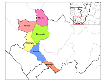
Moungoundou-sud is a district in the Niari Department of Republic of the Congo.
Nyanga is a district in the Niari Department of Republic of the Congo.
Moungoundou-nord is a district in the Niari Department of Republic of the Congo.
Mayéyé is a district in the Lékoumou Department of Republic of the Congo.
Mabombo is a district in the Bouenza Department of Republic of the Congo.
Mbanza–Ndounga is a district in the Pool Department of Republic of the Congo.
Louingui is a district in the Pool Department of Republic of the Congo.
Loumo is a district in the Pool Department of Republic of the Congo.
Ignié is a district in the Pool Department of Republic of the Congo.
Vindza is a district in the Pool Department of Republic of the Congo.
Allembé is a district in the Plateaux Department of Republic of the Congo.
Makotimpoko is a district in the Plateaux Department of Republic of the Congo.
Ngo is a district in the Plateaux Department of Republic of the Congo.
Ollombo is a district in the Plateaux Department of Republic of the Congo.
Ongogni is a district in the Plateaux Department of Republic of the Congo.
Pikounda is a district in the Sangha Department of Republic of the Congo.
Coordinates: 02°19′30″S12°47′51″E / 2.32500°S 12.79750°E
A geographic coordinate system is a coordinate system that enables every location on Earth to be specified by a set of numbers, letters or symbols. The coordinates are often chosen such that one of the numbers represents a vertical position and two or three of the numbers represent a horizontal position; alternatively, a geographic position may be expressed in a combined three-dimensional Cartesian vector. A common choice of coordinates is latitude, longitude and elevation. To specify a location on a plane requires a map projection.
![]() | This Republic of the Congo location article is a stub. You can help Wikipedia by expanding it. |