
Kinshasa, formerly named Léopoldville until 30 June 1966, is the capital and largest city of the Democratic Republic of the Congo. Once a site of fishing and trading villages along the Congo River, Kinshasa is now one of the world's fastest-growing megacities. Kinshasa's 2024 population was estimated at 17,032,322. It is the most densely populated city in the DRC, the most populous city in Africa, the world's fourth-most-populous capital city, Africa's third-largest metropolitan area, and the leading economic, political, and cultural center of the DRC. Kinshasa houses several industries, including manufacturing, telecommunications, banking, and entertainment. The city also hosts some of DRC's significant institutional buildings, such as the Palais du Peuple, Palais de la Nation, Court of Cassation, Constitutional Court, Cité de l'Union Africaine, Palais de Marbre, Stade des Martyrs, Immeuble du Gouvernement, Kinshasa Financial Center, and multiple federal departments and agencies.
Libreville is the capital and largest city of Gabon, located on the Gabon Estuary. Libreville occupies 65 square kilometres (25 sq mi) of the northwestern province of Estuaire. Libreville is also a port on the Gabon Estuary, near the Gulf of Guinea. As of the 2013 census, its population was 703,904.

The Belgian Congo was a Belgian colony in Central Africa from 1908 until independence in 1960 and became the Republic of the Congo (Léopoldville). The former colony adopted its present name, the Democratic Republic of the Congo (DRC), in 1964.

The Democratic Republic of the Congo, also known as the DR Congo, the DRC, or Congo-Kinshasa, is a country in Central Africa. By land area the Congo is the second-largest country in Africa and the 11th-largest in the world. With a population of around 109 million, the Democratic Republic of the Congo is the most populous Francophone country in the world. The national capital and largest city is Kinshasa, which is also the economic center. The country is bordered by the Republic of the Congo, Central African Republic, South Sudan, Uganda, Rwanda, Burundi, Tanzania, Zambia, Angola, the Cabinda exclave of Angola, and the South Atlantic Ocean.
The Congo Free State, also known as the Independent State of the Congo, was a large state and absolute monarchy in Central Africa from 1885 to 1908. It was privately owned by King Leopold II, the constitutional monarch of the Kingdom of Belgium. In legal terms, the two separate countries were in a personal union. The Congo Free State was not a part of, nor did it belong to Belgium. Leopold was able to seize the region by convincing other European states at the Berlin Conference on Africa that he was involved in humanitarian and philanthropic work and would not tax trade. Via the International Association of the Congo, he was able to lay claim to most of the Congo Basin. On 29 May 1885, after the closure of the Berlin Conference, the king announced that he planned to name his possessions "the Congo Free State", an appellation which was not yet used at the Berlin Conference and which officially replaced "International Association of the Congo" on 1 August 1885. The Free State was privately controlled by Leopold from Brussels; he never visited it.

Équateur was a province in the northwest of Belgian Congo and the independent Republic of the Congo, now known as Democratic Republic of the Congo. It had its origins in the Équateur District of the Congo Free State, the private property of King Leopold II of Belgium. It was upgraded to provincial status in 1917. Between 1933 and 1947 it was named Coquilhatville. In 1962 it was divided into three smaller provinces, but there were recombined in 1966. Équateur was one of the eleven provinces of the Democratic Republic of the Congo until 2015, when it was split into the new, smaller Équateur province, as well as the Tshuapa, Mongala, Nord-Ubangi and Sud-Ubangi provinces.
North Kivu is a province bordering Lake Kivu in the eastern Democratic Republic of the Congo. Its capital is Goma. The 2020 population was estimated to be 8,147,400.
Orientale Province is one of the former provinces of the Democratic Republic of the Congo and its predecessors the Congo Free State and the Belgian Congo. It went through a series of boundary changes between 1898 and 2015, when it was divided into smaller units.
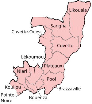
The Republic of the Congo is divided into twelve departments. These departments replaced former regions in 2002:

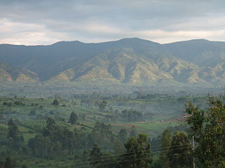
Plateaux is a department of the Republic of the Congo in the central part of the country. It borders the departments of Cuvette, Cuvette Ouest, Lékoumou and Pool, and internationally, the Democratic Republic of the Congo on the east and Gabon on the west. The regional capital is Djambala. Principal cities and towns include Gamboma and Lekana.

The Congo–Ocean Railway links the Atlantic port of Pointe-Noire with Brazzaville, a distance of 502 kilometres (312 mi). It bypasses the rapids on the lower Congo River; from Brazzaville, river boats are able to ascend the Congo River and its major tributaries, including the Oubangui River to Bangui.

Article 2 of the Constitution of the Democratic Republic of the Congo divides the country into the capital city of Kinshasa and 25 named provinces. It also gives the capital the status of a province. Therefore, in many contexts Kinshasa is regarded as the 26th province.
The Departments of the Republic of the Congo are divided into 86 districts and 6 communes; which are further subdivided into urban communities and rural communities ; which are further subdivided into quarters or neighborhoods (quartiers) and villages. Note the departments of Brazzaville and Pointe-Noire are made of 1 commune each, then divided in urban districts (arrondissements).
Société nationale des pétroles du Congo is a national oil company of the Republic of the Congo. The company was established in 1998 after the dissolution of the public company Hydro-Congo. The company manages government-owned shares of production from oil fields in the country. The company has stakes in Moho-Bilondo (15%), Nkossa (15%), M'Boundi (8.8%), Kitina (35%), Sendji (15%), Yanga (15%), Djambala (35%), Foukanda (35%), Mwafi (35%), Emeraude (49%), Yombo (44%), Tilapia (35%), Azurite (15%), and Turquoise Marine-1 (15%) fields. It owns the refinery company named Congolaise de Raffinage (CORAF).
Railway stations in the Republic of the Congo (Congo) include:

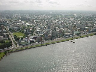
Congo, officially the Republic of the Congo or Congo Republic, also known as Congo-Brazzaville is a country located on the western coast of Central Africa to the west of the Congo River. It is bordered to the west by Gabon, to the northwest by Cameroon, to the northeast by the Central African Republic, to the southeast by the Democratic Republic of the Congo, to the south by the Angolan exclave of Cabinda, and to the southwest by the Atlantic Ocean.
The Republic of the Congo includes 16 communes, some divided in urban boroughs (arrondissements) and in quarters.
Moembe is a town in Djambala District in the Plateaux Department of the Republic of the Congo. It lies in the Lefini Reserve on the Lefini River, south of Etsouali and on the N2 road. The primary language for occupants here is French, the nearest city is Kikwit at 170km.

Pierre-Ernest Abandzounou was a Congolese politician. He served in the government of Congo-Brazzaville as Secretary of State for Scientific Research from August 2002 to January 2005 and then as Minister of Scientific Research from January 2005 to December 2007. He was also the President of the Action Committee for Progress (CAP) from 2005 to 2011. Starting in 2012, he was Congo-Brazzaville's Ambassador to Chad.
Djambala Airport is an airport serving Djambala, a city in the Plateaux Department of Republic of the Congo.

