
Kinshasa, formerly named Léopoldville until 30 June 1966, is the capital and largest city of the Democratic Republic of the Congo. Once a site of fishing and trading villages along the Congo River, Kinshasa is now one of the world's fastest-growing megacities. Kinshasa's 2024 population was estimated at 17,032,322. It is the most densely populated city in the DRC, the most populous city in Africa, the world's fourth-most-populous capital city, Africa's third-largest metropolitan area, and the leading economic, political, and cultural center of the DRC. Kinshasa houses several industries, including manufacturing, telecommunications, banking, and entertainment. The city also hosts some of DRC's significant institutional buildings, such as the Palais du Peuple, Palais de la Nation, Court of Cassation, Constitutional Court, Cité de l'Union Africaine, Palais de Marbre, Stade des Martyrs, Immeuble du Gouvernement, Kinshasa Financial Center, and multiple federal departments and agencies.

The Sangha River, a tributary of the Congo River, is located in Central Africa.
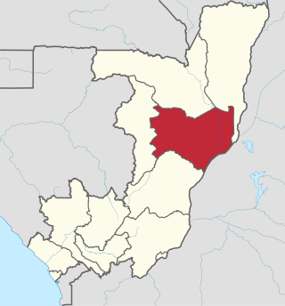
Cuvette is a department of the Republic of the Congo in the central part of the country. It borders the departments of Cuvette-Ouest, Likouala, Plateaux, and Sangha, and internationally, the Democratic Republic of the Congo. The capital is Owando. Cities and towns include Boundji, Makoua and Okoyo.

Sangha is a department of the Republic of the Congo in the northern part of the country. It borders the departments of Cuvette, Cuvette-Ouest, and Likouala, and internationally, Cameroon, Gabon and the Central African Republic. The regional capital is Ouésso. Principal towns include Sembé and Souanké.

Ouésso is a town and commune in the Ouésso District in northern Republic of the Congo at the border of Cameroon, lying on the Sangha River and surrounded by rainforest. It is the capital of the Sangha Department.
Gombe, also known as La Gombe, or Downtown Kinshasa, is one of the 24 communes of Kinshasa, in the western part of the Democratic Republic of the Congo. Encompassing a vast area of approximately 29.33 square kilometers, it is home to an approximate population of 49,024 residents (2014).
Kabo or KABO may refer to:
The Departments of the Republic of the Congo are divided into 86 districts and 6 communes; which are further subdivided into urban communities and rural communities ; which are further subdivided into quarters or neighborhoods (quartiers) and villages. Note the departments of Brazzaville and Pointe-Noire are made of 1 commune each, then divided in urban districts (arrondissements).

Congo, officially the Republic of the Congo or Congo Republic, also known as Congo-Brazzaville is a country located on the western coast of Central Africa to the west of the Congo River. It is bordered to the west by Gabon, to the northwest by Cameroon, to the northeast by the Central African Republic, to the southeast by the Democratic Republic of the Congo, to the south by the Angolan exclave of Cabinda, and to the southwest by the Atlantic Ocean.
The Republic of the Congo includes 16 communes, some divided in urban boroughs (arrondissements) and in quarters.

Nouabalé-Ndoki National Park is a national park in the Republic of the Congo. Established in 1993, in the northern provinces of Congo, it is home to forest elephants, great apes, including western lowland gorillas and the eastern sub-species of chimpanzees and bongo. It is 3,921.61 km2 (1,514.14 sq mi) of pristine tropical rainforest with no human habitation within it and with human population densities in its periphery that are comparatively low for the sub-region. The forests have a rich biodiversity of 300 bird species, plus 1,000 plant and tree species which include endangered mahoganies.
The Lake Télé Community Reserve is found in the Republic of the Congo. It was established on the 10 May 2001. This site covers 4,389 square kilometres (1,695 sq mi) around Lake Télé. In August 2010, the Cooperation Agreement between the governments of the Republic of the Congo and the Democratic Republic of the Congo (DRC) on the Lake Tele - Lake Tumba landscape provided for creation of a trans-national protected area including the Lake Télé Community Reserve and the Ngiri-Tumba-Maindombe area in the DRC.

Lobéké National Park is a national park of southeastern Cameroon within the Moloundou Arrondissement of East Province. Located in the Congo Basin, it is bounded on the east by the Sangha River which serves as Cameroon's international border with Central African Republic and the Republic of the Congo. It is adjacent to two other reserves in the CAR and Congo. To the northwest is Boumba Bek National Park, another national park in Cameroon's East Province.
René-Dambert Ndouane is a Congolese politician who served in the government of Congo-Brazzaville as Minister of Tourism from 1997 to 1999 and as Minister of Labour from 1999 to 2002. He was Second Vice-President of the National Assembly from 2002 to 2007 and First Vice-President of the National Assembly from 2012 to 2017.

The Northwestern Congolian lowland forests is a tropical moist broadleaf forest ecoregion that spans Cameroon, Gabon, the Republic of Congo, the Central African Republic and a minuscule part of the Democratic Republic of the Congo. It forms part of the larger Congolian rainforests region in Central Africa. The region is noteworthy for very high levels of species richness and endemism. It is home to a core population of the critically endangered Western lowland gorilla. There are also large populations of forest elephants.
Mokéko is a district in the Sangha Department of Republic of the Congo.
Pikounda is a district in the Sangha Department of Republic of the Congo.
N'gbala is a district in the Sangha Department of Republic of the Congo.

The Likouala-aux-Herbes is a river in the Republic of the Congo. It is a tributary of the Sangha River, which in turn is a tributary of the Congo River. It gives its name to the Likouala Department.

