The Arctic Archipelago, also known as the Canadian Arctic Archipelago, is an archipelago lying to the north of the Canadian continental mainland, excluding Greenland and Iceland.
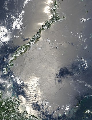
The Sulu Sea is a body of water in the southwestern area of the Philippines, separated from the South China Sea in the northwest by Palawan and from the Celebes Sea in the southeast by the Sulu Archipelago. Borneo is found to the southwest and Visayas to the northeast.
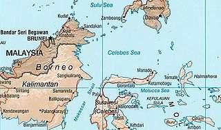
The Celebes Sea or Sulawesi Sea of the western Pacific Ocean is bordered on the north by the Sulu Archipelago and Sulu Sea and Mindanao Island of the Philippines, on the east by the Sangihe Islands chain, on the south by Sulawesi's Minahasa Peninsula, and the west by northern Kalimantan in Indonesia. It extends 420 miles (675 km) north-south by 520 mi (840 km) east-west and has a total surface area of 110,000 square miles (280,000 km2), to a maximum depth of 20,300 feet (6,200 m). South of the Cape Mangkalihat, the sea opens southwest through the Makassar Strait into the Java Sea.
This is a list of the extreme points of the United Kingdom: the points that are farther north, south, east or west than any other location. Traditionally the extent of the island of Great Britain has stretched "from Land's End to John o' Groats".
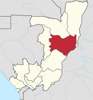
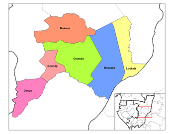
Cuvette is a department of the Republic of the Congo in the central part of the country. It borders the departments of Cuvette-Ouest, Likouala, Plateaux, and Sangha, and internationally, the Democratic Republic of the Congo. The capital is Owando. Cities and towns include Boundji, Makoua and Okoyo.
Makoua is a town in the Republic of the Congo, lying on the equator at the southern edge of the rainforest, north of Owando. It is the seat of the Makoua District in the Cuvette Department.

Jordán is a town and municipality in the Santander Department in northeastern Colombia.

El Madania is a municipality in Algiers Province, Algeria. It is administratively part of Sidi M'Hamed district. Its municipal code is 1603 and postal code is 16075. It has a population of 51,404 as of the 1998 census, which gives it 15 seats in the PMA.
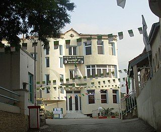
Tizi N'Berber is a commune in northern Algeria in the Béjaïa Province in the Kabylia region.

Nowendoc River, a perennial river of the Manning River catchment, is located in the Northern Tablelands and Mid North Coast districts of New South Wales, Australia.
Rowleys River, a perennial river of the Manning River catchment, is located in the Northern Tablelands and Mid North Coast districts of New South Wales, Australia.
Puerto Carabuco is a location in the La Paz Department in Bolivia.
Bazou is a town and commune located in the West Region of Cameroon. The town consists of 63 villages, and is one of the three subdivisions of the department of Ndé. Covering around 250 km2, it is located on the high plateau of Bamileke, 950–1400 m above sea level. The name Bazou comes from the Baze expression for walking because of the long migratory marches caused by frequent internal conflicts.

Murla is a village in the province of Alicante and autonomous community of Valencia, Spain. The municipality covers an area of 5.81 square kilometres (2.24 sq mi) and as of 2022 had a population of 540 people.
Makoua Airport is an airport serving the town of Makoua in the Cuvette Department, Republic of the Congo. The runway is 4 kilometres (2.5 mi) west of the town.
The Lossuk is a river of north-western New Ireland, Papua New Guinea. The sedimentation and mineral deposits of the river was studied in the mid 1980s.

Mountain Empire Airport is a public use airport in Smyth County, Virginia, United States. It located nine nautical miles northeast of the central business district of Marion and 13 nautical miles west of Wytheville. The airport is situated between Interstate 81 and U.S. Route 11, near Groseclose. It is owned by Smyth Wythe Airport Commission.

The Squalo-class submarines were a group of four submarines built for the Royal Italian Navy during the 1930s. They were built at the Cantieri Riuniti dell'Adriatico (CRDA) shipyard at Monfalcone, and designed by Curio Bernardis.

German submarine U-929 was a Type VIIC/41 U-boat of Nazi Germany's Kriegsmarine during World War II.

German submarine U-1102 was a Type VIIC U-boat of Nazi Germany's Kriegsmarine during World War II.
This page is based on this
Wikipedia article Text is available under the
CC BY-SA 4.0 license; additional terms may apply.
Images, videos and audio are available under their respective licenses.
