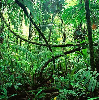
Rainforests are forests characterized by a closed and continuous tree canopy, moisture-dependent vegetation, the presence of epiphytes and lianas and the absence of wildfire. Rainforests can be generally classified as tropical rainforests or temperate rainforests, but other types have been described.
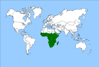
The Afrotropical realm is one of the Earth's eight biogeographic realms. It includes Sub-Saharan Africa, the southern Arabian Peninsula, the island of Madagascar, and the islands of the western Indian Ocean. It was formerly known as the Ethiopian Zone or Ethiopian Region.

In anthropology, pygmy peoples are ethnic groups whose average height is unusually short. The term pygmyism is used to describe the phenotype of endemic short stature for populations in which adult men are on average less than 150 cm tall.
Ogooué-Ivindo Province is the northeasternmost of Gabon's nine provinces, though its Lopé Department is in the very center of the country. It gets its name from two rivers, the Ogooué and the Ivindo. This province, containing thousands of square kilometres of rainforest, is the largest and most sparsely populated and much less developed than the rest of the country. As of 2013 it had a population of 63,293 people. The principal town is Makokou.
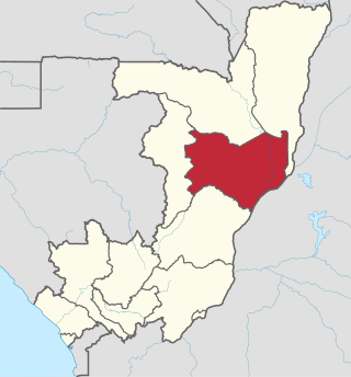
Cuvette is a department of the Republic of the Congo in the central part of the country. It borders the departments of Cuvette-Ouest, Likouala, Plateaux, and Sangha, and internationally, the Democratic Republic of the Congo. The capital is Owando. Cities and towns include Boundji, Makoua and Okoyo.

The Ituri Rainforest is a rainforest located in the Ituri Province of northeastern Democratic Republic of the Congo. The forest's name derives from the nearby Ituri River which flows through the rainforest, connecting firstly to the Aruwimi River and finally into the Congo.

Lignes Nationales Aériennes Congolaises, also known as Lina Congo, was the national airline of the Republic of Congo before ECAir in 2010.

Ouésso is a town and commune in the Ouésso District in northern Republic of the Congo at the border of Cameroon, lying on the Sangha River and surrounded by rainforest. It is the capital of the Sangha Department.

Dolisie, known as Loubomo between 1975 and 1991, is a city and a commune. It is the capital of Niari in the south western of the Republic of the Congo, the country's third largest city and an important commercial centre. The city lies on the eastern edge of the coastal rainforest and has a population of 178,172.

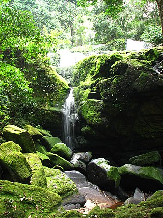
The Congo Basin is the sedimentary basin of the Congo River. The Congo Basin is located in Central Africa, in a region known as west equatorial Africa. The Congo Basin region is sometimes known simply as the Congo. It contains some of the largest tropical rainforests in the world and is an important source of water used in agriculture and energy generation.

The Congolian rainforests are a broad belt of lowland tropical moist broadleaf forests which extend across the basin of the Congo River and its tributaries in Central Africa.

The Amazon Cooperation Treaty Organization (ACTO) is an international organization aimed at the promotion of sustainable development of the Amazon Basin. Its member states are: Bolivia, Brazil, Colombia, Ecuador, Guyana, Peru, Suriname and Venezuela.

The forest hinge-back tortoise, also known commonly as the serrated hinge-back tortoise or Schweigger's tortoise, is a species of tortoise in the family Testudinidae. The species is indigenous to the tropical forests and marshes of central and western Africa.
Makoua Airport is an airport serving the town of Makoua in the Cuvette Department, Republic of the Congo. The runway is 4 kilometres (2.5 mi) west of the town.
The wildlife of the Republic of the Congo is a mix of species of different kinds of organisms. There are 400 mammal species, 1,000 bird species and 10,000 plant species in the country. Many parts of the country are covered in tropical rainforest, although some of the southern areas have been cleared by logging.
The eastern rainforest grammomys, also known as the eastern rainforest thicket rat, is a species of rodent from the family Muridae.

Mountain Empire Airport is a public use airport in Smyth County, Virginia, United States. It located nine nautical miles northeast of the central business district of Marion and 13 nautical miles west of Wytheville. The airport is situated between Interstate 81 and U.S. Route 11, near Groseclose. It is owned by Smyth Wythe Airport Commission.

Stanislas Batchi Boussandji was a politician and the Congolese ambassador to the United States and the United Nations from June 5, 1985 to December 21, 1987.

The Likouala-Mossaka is a river in the Republic of the Congo. It is a tributary of the Congo River, which it enters to the east of the town of Mossaka.
