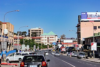
Maseru is the capital and largest city of Lesotho. It is also the capital of the Maseru District. Located on the Caledon River, Maseru lies directly on the Lesotho–South Africa border. Maseru had a population of 330,760 in the 2016 census. The city was established as a police camp and assigned as the capital after the country became a British protectorate in 1869. When the country achieved independence in 1966, Maseru retained its status as capital. The name of the city is a Sesotho word meaning "red sandstones".
Semonkong is a community council located in the Maseru District of Lesotho. Semonkong, meaning "Place of Smoke", was established in the 1880s as a refuge for Basotho displaced by the Basuto Gun War. It is located close to several major natural features, including the Maletsunyane Falls and the 3096-metre peak of Thaba Putsoa. The population in 2006 was 7,781.

Matekane Air Strip is a high elevation airstrip serving Matekane, Lesotho, with a runway that extends to the edge of a 500 m (1,600 ft) cliff. The runway is often used by charity organizations and doctors to access remote villages in the area, and is known as one of the world's scariest runways.
Kueneng is a community council located in the Berea District of Lesotho. Its population in 2006 was 21,887.
Lipelaneng is a community council located in the Butha-Buthe and Leribe Districts of Lesotho. Its population in 2006 was 30,320.
'Moteng is a community council located in the Butha-Buthe District of Lesotho. Its population in 2006 was 16,838.
Tsoilitsoili is a community council located in the Leribe District of Lesotho. Its population in 2006 was 18,456.
Makolopetsane is a community council located in the Maseru District of Lesotho. Its population in 2006 was 7,415.
Manonyane is a community council located in the Maseru District of Lesotho. Its population in 2006 was 22,491.
Mateanong is a community council located in the Mokhotlong District of Lesotho. Its population in 2006 was 7,387.
Makheka is a community council located in the Maseru District of Lesotho. The population in 2006 was 5,473.
Makhalaneng is a community council located in the Maseru District of Lesotho. The population in 2006 was 13,146.
Mabote is a community council in the Maseru Municipality located in the Berea District of Lesotho. The population in 2006 was 38,047.
Abia is a constituency and community council in the Maseru Municipality located in the Maseru District of Lesotho. The population in 2006 was 17,449.
Lithabaneng is a constituency and community council in the Maseru Municipality located in the Maseru District of Lesotho. The population in 2006 was 28,371.
Lithoteng is a constituency and community council in the Maseru Municipality located in the Maseru District of Lesotho. The population in 2006 was 26,593.
Motimposo is a constituency and community council in the Maseru Municipality located in the Maseru District of Lesotho. The population in 2006 was 24,714.
Qoaling is a constituency and community council in the Maseru Municipality located in the Maseru District of Lesotho. The population in 2006 was 33,989.
Stadium Area is a constituency and community council within the Maseru Municipality, in the Maseru District of Lesotho. The population in 2006 was 21,906.
Maseru Central is a constituency and community council in the Maseru Municipality located in the Maseru District of Lesotho. The population in 2006 was 37,529.
