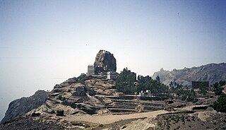
Hutayb is a village in west-central Yemen. It is located in the San‘a’ Governorate.
Al Madan District is a district of the 'Amran Governorate, Yemen. As of 2003, the district had a population of 26,955 inhabitants.
Amran District is a district of the 'Amran Governorate, Yemen. As of 2003, the district had a population of 96,375 inhabitants. The capital lies at `Amran.
Bani Suraim District is a district of the 'Amran Governorate, Yemen. As of 2003, the district had a population of 32,698 inhabitants.
Maswar District is a district of the 'Amran Governorate, Yemen. As of 2003, the district had a population of 38,432 inhabitants. In the early 20th century, the mountain village was visited by German explorer and photographer, Hermann Burchardt.

Al Wade'a District is a district of the Abyan Governorate, Yemen. As of 2003, the district had a population of 23,400 inhabitants.
Sibah District is a district of the Abyan Governorate, Yemen. As of 2003, the district had a population of 15,996 inhabitants.
Ad Durayhimi District is a district of the Al Hudaydah Governorate, Yemen. As of 2003, the district had a population of 55,013 inhabitants.
Al Mansuriyah District is a district of the Al Hudaydah Governorate, Yemen. As of 2003, the district had a population of 44,744 inhabitants.
Bura District is a district of the Al Hudaydah Governorate, Yemen. As of 2003, the district had a population of 45,116 inhabitants.
Ash Shaghadirah District is a district of the Hajjah Governorate, Yemen. As of 2003, the district had a population of 48,746 inhabitants.
Qafl Shamer District is a district of the Hajjah Governorate, Yemen. As of 2003, the district had a population of 50,439 inhabitants.
Rakhyah District is a district of the Hadhramaut Governorate, Yemen. As of 2003, the district had a population of 8,715 inhabitants.
Yabuth District is a district of the Hadhramaut Governorate, Yemen. As of 2003, the district had a population of 9,862 inhabitants.
Baqim District is a district of the Sa'dah Governorate, Yemen. As of 2003, the district had a population of 22,965 people.
Majz District is a district of the Sa'dah Governorate, Yemen. As of 2003, the district had a population of 68,598 inhabitants.
Saqayn District is a district of the Sa'dah Governorate, Yemen. As of 2003, the district had a population of 52,521 inhabitants.
Al Haymah Al Kharijiyah District is a district of the Sana'a Governorate, Yemen. As of 2003, the district had a population of 58,454 inhabitants.

Arhab District is a district of the Sana'a Governorate, Yemen. As of 2003, the district had a population of 90,038 inhabitants.

Nihm District is a district of the Sana'a Governorate, Yemen. As of 2003, the district had a population of 41,502 inhabitants.


