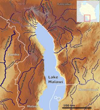
Mbaka River is a river of Mbeya Region, Tanzania. It originates on the south slopes of Mount Rungwe [1] and flows southeast into the north end of Lake Malawi at Mwaya. [2]
Mbeya Region is one of Tanzania's 31 administrative regions. The region covers an area of 35,954 km2 (13,882 sq mi). The region is comparable in size to the combined land area of the nation state of Guinea Bissau. Mbeya Region is bordered to the east by Singida Region, Iringa Region and Njombe Region. The region is bordered to the south by Malawi and Lake Nyasa. To the north the region borders southern Tabora Region. Lastly, Mbeya is bordered to the west by Songwe Region. The regional capital is the city of Mbeya. According to the 2012 national census, the region had a population of 2,707,410.
Rungwe is a District in Mbeya Region, Tanzania. It is bordered to the north by Mbeya Rural District, to the east by Busokelo District, to the southeast by Kyela District, to the southwest by Ileje District and to the west by Mbeya District.
Kyela is one of the seven districts of Mbeya Region, Tanzania. It is bordered to the north by Rungwe District, to the northeast by Njombe Region, to the southeast by Lake Nyasa, to the south by Malawi and to the west by Ileje District.
Mount Rungwe is a volcanic mountain in Mbeya Region, in Tanzania's Southern Highlands. At an altitude of 2,981 metres (9,780 ft), it is southern Tanzania's second-highest peak. Rungwe's volcano is currently inactive.
Katumba is an administrative ward in the Rungwe District of the Mbeya Region of Tanzania. According to the 2002 census, the ward has a total population of 10,965.
Kisiba is an administrative ward in the Rungwe district of the Mbeya Region of Tanzania. In 2016 the Tanzania National Bureau of Statistics report there were 7,306 people in the ward, from 6,629 in 2012.
Mpuguso is an administrative ward in the Rungwe district of the Mbeya Region of Tanzania. According to the 2002 census, the ward has a total population of 12,223.
The Poroto Mountains are a mountain range in the Mbeya Region of Tanzania. They are located east of the city of Mbeya. The Poroto Mountains are a northwestward extension of the Kipengere Range, and part of the Southern Highlands. The Poroto mountains are volcanic in origin, part of the geological Rungwe Volcanic Province.
Kiwira River is a river located in Rungwe District and Kyela District of Mbeya Region, Tanzania.
Suma River is a river of Mbeya Region, Tanzania. It originates on the southern slopes of Mount Rungwe and is a tributary of the Mbaka River.
Mwatisi is a river of Tanzania. It flows through the Mbeya Region.
The Southern Highlands is a highland region in southwestern Tanzania, at the northern end of Lake Malawi. The highlands include portions of Mbeya, Njombe, Rukwa, Ruvuma, and Songwe regions, bordering Malawi, Mozambique, and Zambia. Mbeya is the largest city in the highlands.
Lupope is an administrative ward in Rungwe District, Mbeya Region, Tanzania. As of 2002, the ward had a total population of 14,284.
Makandana is an administrative ward in Rungwe District, Mbeya Region, Tanzania. As of 2002, the ward had a total population of 14,284.
Masebe is an administrative ward in Rungwe District, Mbeya Region, Tanzania. As of 2002, the ward had a total population of 14,284.
Masoko is an administrative ward in Rungwe District, Mbeya Region, Tanzania. As of 2002, the ward had a total population of 14,284.
Matwebe is an administrative ward in Rungwe District, Mbeya Region, Tanzania. As of 2002, the ward had a total population of 14,284.
Ndato is an administrative ward in Rungwe District, Mbeya Region, Tanzania. As of 2002, the ward had a total population of 14,284.
Swaya is an administrative ward in Rungwe District, Mbeya Region, Tanzania. As of 2002, the ward had a total population of 14,284.
Suma is an administrative ward in Rungwe District, Mbeya Region, Tanzania. As of 2002, the ward had a total population of 11,448.
9°33′00″S33°57′30″E / 9.5500°S 33.9584°E