
Kampala is the capital and largest city of Uganda. The city proper has a population of 1,680,000 and is divided into the five political divisions of Kampala Central Division, Kawempe Division, Makindye Division, Nakawa Division, and Rubaga Division.

Kitale is an agricultural town in the northern Rift Valley, situated between Mount Elgon and the Cherangany Hills.The town has an elevation of around 1,900 metres (6,200 ft) Its population is 162,174 as of 2019. Kitale is the headquarter town of Trans-Nzoia County. Kitale is reachable by air through Kitale Airport. The postal code for Kitale is 30200.

Ankole was a traditional Bantu kingdom in Uganda and lasted from the 15th century until 1967. The kingdom was located in south-western Uganda, east of Lake Edward.
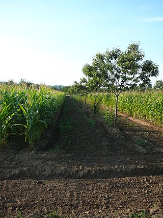
Agroforestry refers to any of a broad range of land use practices where pasture or crops are integrated with trees and shrubs. This intentional combination of agriculture and forestry has multiple benefits, such as greatly enhanced yields from staple food crops, enhanced farmer livelihoods from income generation, increased biodiversity, improved soil structure and health, reduced erosion, and carbon sequestration. Trees in agroforestry systems can also produce wood, fruits, nuts, and other useful products with economic and practical value. Agroforestry practices are especially prevalent in the tropics, especially in subsistence smallholdings areas with particular importance in sub-Saharan Africa. However, due to its multiple benefits, for instance in nutrient cycle benefits and potential for mitigating droughts, it has been adopted in the USA and Europe.
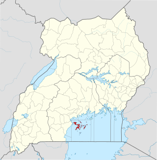
Kalangala, also known as Ssesse, is a district in Central Uganda. The district is coterminous with the Ssese Islands in Lake Victoria and does not have territory on mainland Uganda. Like other Ugandan districts, it is named after its 'chief town', Kalangala which is located on Bugala Island, the largest of the Ssese Islands.

Mpigi District is a district in Central Uganda. Like most other Ugandan districts, it is named after its 'main town', Mpigi.

Lake Wamala is a freshwater lake in Uganda. Its wetlands contain endangered species of birds and animals including the sitatunga. The lake is of traditional and cultural significance to the people of Buganda in Central Uganda.
Lubaga is a hill in Kampala, Uganda's capital and largest city. It comes from the Luganda word okubaga, describing a process of "planning" or "strengthening" a structure while constructing it. For example, okubaga ekisenge means to strengthen the internal structure of a wall while building a house. The name also applies to the neighborhood on the hill.

Butambala District is a district in the Central Region of Uganda.

Gomba is a district in Central Uganda.
Mpigi General Hospital, also Mpigi Hospital, is a hospital in the Central Region of Uganda.
Deforestation is a primary contributor to climate change, and climate change affects forests.

The Mpanga Central Forest Reserve is a Forest Reserve in Uganda. It is a small patch of natural equatorial rainforest covering 453 hectares. It is situated in Mpigi District, Mpambire, 37 km southwest of Kampala City. Onsite is Mpanga Forest Resort managed by Global Afric Safaris since 2018.
Maya is a town in the Central Region of Uganda. It is one of the urban centers in Wakiso District.
Kayabwe, is a town in the Buganda Region of Uganda. It is an urban center in Mpigi District.The LC 5 Councilor of Kayabwe TC is Mr. Mwanje Alex Andrew. The town sits astride The Equator.

The Victoria Basin forest–grassland mosaic is an ecoregion that lies mostly in Uganda and extends into neighboring countries. The ecoregion is centered north and west of Lake Victoria, with an outlier on the border of Ethiopia and South Sudan.
Operation Dada Idi was a military offensive conducted by Tanzania against the Ugandan government of Idi Amin and its Libyan as well as Palestinian allies in March and April 1979 during the Uganda–Tanzania War. The attack took place amid the disintegration of the Uganda Army, and thus encountered only sporadic and disorganised resistance. The operation resulted in the Tanzanian capture of Mpigi and several other locations around Kampala.
Jezza is a village situated in the Mpigi District of Uganda, just outside of the capital city Kampala. The village is served by the A109 highway.
Teddy Nambooze is a Ugandan accountant and a legislator. She serves as the elected Woman Member of Parliament for Mpigi district in Uganda's 11th parliament. Politically she is affiliated to National Unity Platform (NUP) under whose ticket she contested and won in the 2021 general elections.
Mugomba Central Forest Reserve is a 100-hectare (247-acre) forest reserve located in Entebbe, Central Uganda. It is part of the Central Forest Reserves of Uganda, which are managed by the National Forestry Authority (NFA).


