Related Research Articles

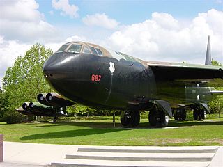
Strategic Air Command (SAC) was a United States Department of Defense Specified Command and a United States Air Force (USAF) Major Command responsible for command and control of the strategic bomber and intercontinental ballistic missile components of the United States military's strategic nuclear forces from 1946 to 1992. SAC was also responsible for strategic reconnaissance aircraft; airborne command posts; and most of the USAF's aerial refueling aircraft.
McCoy AFB is a former U.S. Air Force installation located 10 miles (16 km) southeast of Orlando, Florida. It was a training base during World War II. From 1951 to 1975, it was a frontline Strategic Air Command (SAC) base during the Cold War and Vietnam War. It was Orlando's biggest employer and economic backbone prior to the opening of Walt Disney World in 1971.

Mather Air Force Base was a United States Air Force Base, which was closed in 1993 pursuant to a post-Cold War BRAC decision. It was located 12 miles (19 km) east of Sacramento, on the south side of U.S. Route 50 in Sacramento County, California. Mather Field was one of 32 Air Service training camps established after the United States entry into World War I in April 1917.

McClellan Air Force Base (1935–2001) is a former United States Air Force base located in the North Highlands area of Sacramento County, 7 miles (11 km) northeast of Sacramento, California.

Aerospace Defense Command was a major command of the United States Air Force, responsible for air defense of the continental United States. It was activated in 1968 and disbanded in 1980. Its predecessor, Air Defense Command, was established in 1946, briefly inactivated in 1950, reactivated in 1951, and then redesignated Aerospace rather than Air in 1968. Its mission was to provide air defense of the Continental United States (CONUS). It directly controlled all active measures, and was tasked to coordinate all passive means of air defense.

Sacramento McClellan Airport is a privately-owned, public-use airport located in the unincorporated area of McClellan Park, California, six miles northeast of the central business district of Sacramento, the California state capital.
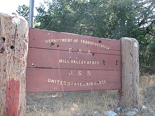
Ground Equipment Facility J-33 is a Federal Aviation Administration (FAA) radar station of the Joint Surveillance System's Western Air Defense Sector (WADS) with an Air Route Surveillance Radar (ARSR-4). The facility was previously a USAF general surveillance radar station during the Cold War.

The 1st Combat Evaluation Group was a Strategic Air Command (SAC) unit. It was formed on 1 August 1961 to merge the 3908th Strategic Standardization Group for SAC aircrew evaluation with the 1st Radar Bomb Scoring Group that had originated from the 263rd Army Air Force Base Unit which transferred from 15th AF to directly under Strategic Air Command c. 1946. The 1CEVG formed after SAC switched to low-level tactics to counter Soviet surface-to-air missiles and SAC had "developed a Radar Bomb Scoring field kit for use in NIKE Systems" in early 1960 for scoring SAC training missions against US Hercules SAM sites. The 1CEVG headquarters included an Office of History and a "standardization and evaluation school" for command examiners.

The 502d Air Operations Group in an inactive United States Air Force unit. It was last active in October 2006 at Hickam Air Force Base, Hawaii, where it had served as the umbrella for intelligence and operational support units under Pacific Air Forces

The Eastern Air Defense Sector (EADS) is a United States Air Force unit of Air Combat Command (ACC), permanently assigned to the North American Aerospace Defense Command (NORAD). A joint, bi-national military organization, EADS is composed of US and Canadian military forces, federal civilians and contractors. It is located at the Griffiss Business and Technology Park in Rome, New York, the former Griffiss Air Force Base. EADS is a subordinate command of the First Air Force and Continental NORAD Region, located at Tyndall Air Force Base in Florida.
Cheli Air Force Station, formerly located within Bell in southeastern Los Angeles County, California, was a United States Air Force installation and a Cold War Radar Bomb Scoring site of the Strategic Air Command, from 1947 to 1961.
Radar Bomb Scoring is a combat aviation ground support operation used to evaluate Cold War aircrews' effectiveness with simulated unguided bomb drops near radar stations of the United States Navy, the USAF Strategic Air Command, and Army Project Nike units. USAF RBS used various ground radar, computers, and other electronic equipment such as jammers to disrupt operations of the bomber's radar navigator, AAA/SAM simulators to require countermeasures from the bomber, and Radar Bomb Scoring Centrals for estimating accuracy of simulated bombings. Scores for accuracy and electronic warfare effectiveness were transmitted from radar sites such as those at Strategic Range Training Complexes.
The AN/MPQ-2 Close Cooperation Control Unit was a truck-mounted pautomatic tracking radar/computer/communication system for aircraft command guidance, e.g., missile tracking, and for Radar Bomb Scoring. It was introduced shortly after the end of World War II. For ground directed bombing (GDB), an operator would manually plot a target on the "Blind Bombing Plotting Sheet", then use the manual "E6B computer and bombing tables" to plot the release point for striking the target, after which a radar operator used the AN/MPQ-2 to acquire a track of the bomber near an initial point during which allowed ground control of the bomb run to the release point.

The 99th Range Group is an inactive United States Air Force (USAF) unit. It was last stationed at Nellis AFB, Nevada, where it was responsible for the Nevada Test and Training Range (NTTR).
The Stockton Ordance Depot was a World War II vehicle repair facility, supply depot, and camp for German and Italian prisoners of war. The installation was also used as a USAF radar station and a DLA Defense Distribution Center.
The 3903rd Radar Bomb Scoring Group was a military evaluation unit under direct command of Strategic Air Command (SAC) headquarters for scoring simulated bomb runs using automatic tracking radar stations. Initially an Army Air Forces Base Unit (AAFBU) and then a squadron, the 3903rd RBS Group was personnel, assets, and detachments were redesignated the 1st Radar Bomb Scoring Group and then the 1CEVG Radar Bomb Scoring Division when the RBS Group merged with the 3908th Strategic Standardization Group in 1961, the year RBS Express trains began to be used for low-altitude Boeing B-52 Stratofortress operations..
The Reeves AN/MSQ-1 Close Support Control Set produced by Reeves Instrument Corporation was a trailer-mounted combination radar/computer/communication developed under a Rome Air Development Center program office for Cold War command guidance of manned aircraft Developed for Korean War ground-directed bombing, one detachment of the 3903rd Radar Bomb Scoring Squadron bombed itself with an MSQ-1 because it mistakenly used procedures for the earlier SCR-584/OA-294 system The MSQ-1 was subsequently used for nuclear testing during Operation Teapot, and for aircraft tests such as for "MSQ-1 controlled pinpoint photography" in 1954.
Genesee Mountain Park Training Annex (1955–70) was a U.S. Air Force radar station, an outstation of Lowry Air Force Base. It is a Formerly Used Defense Site of 3 acres (1.2 ha) at Genesee Park (Colorado)
Sacramento Air Logistics Center is a former United States Air Force unit based at McClellan Air Force Base from 1935 until its closure as part of the 1995 Base Realignment and Closure Commission.

Fairfax Field was a wartime (WWII) facility of the United States Army Air Forces and later, the United States Air Force. The installation was north of Kansas City, Kansas. Used as a pre-war Naval Air Station, the United States Army Air Forces leased the municipal airfield and built an Air Force Plant and modification center for North American B-25 Mitchell medium bomber production. Military use of the site continued as late as 1957 by the Strategic Air Command's 3903rd Radar Bomb Scoring Group for bombing practice.
References
- 1 2 Mueller, Robert (1989). Air Force Bases (PDF) (Report). Vol. Active Air Force Bases Within the United States of America on 17 September 1982. Office of Air Force History. p. 398. ISBN 0-912799-53-6 . Retrieved 7 April 2016.
- ↑ "Eastern Avenue & Whitney Avenue, Sacramento, CA". Google Maps. Retrieved 13 October 2013.
- ↑ "3903rd Radar Bomb Scoring Group - USAF - Korean War Project Page 1". www.koreanwar.org. Retrieved 7 April 2016.