
North East England is one of nine official regions of England at the first level of ITL for statistical purposes. The region covers an area of 8,592 km2 and in 2019 had a recorded population of nearly 2.7 million. There are four counties in the region: County Durham; Tyne and Wear; Northumberland and part of North Yorkshire. The largest settlements are Newcastle upon Tyne, Middlesbrough, Sunderland, Gateshead and Darlington. There are three conurbations in the region: Tyneside ; Wearside ; and Teesside. Only three settlements in the region have city status: Newcastle upon Tyne, Sunderland and Durham.

Tyne and Wear is a metropolitan county in North East England, situated around the mouths of the rivers Tyne and Wear. It came into existence in 1974 after the passage of the Local Government Act 1972. It consists of five metropolitan boroughs - Newcastle upon Tyne, Gateshead, North Tyneside, South Tyneside and the City of Sunderland. The county is bordered to the north by Northumberland, to the south by County Durham and to the east of the county lies the North Sea. It is the smallest county in North East England by area, but by far the largest in terms of population.

The River Tyne is a river in North East England. Its length is 73 miles (118 km). It is formed by the North Tyne and the South Tyne, which converge at Warden Rock near Hexham in Northumberland at a place dubbed 'The Meeting of the Waters'.
Gateshead is a large town in North East England and principal settlement of the Metropolitan Borough of Gateshead, situated on the southern bank of the River Tyne. It is connected to Newcastle upon Tyne by seven bridges. The town is known for its architecture, including The Sage, the Angel of the North and the Baltic Centre for Contemporary Art. In 2011, the population of Gateshead town was recorded as 120,046.

The Metropolitan Borough of Gateshead is a metropolitan borough in the metropolitan county of Tyne and Wear, North East England. It includes Gateshead, Rowlands Gill, Whickham, Blaydon, Ryton, Felling, Pelaw, Dunston and Low Fell. The borough forms part of the Tyneside conurbation, centred on Newcastle upon Tyne.

Gateshead Football Club is a professional football club based in Gateshead, England. The team compete in the National League North, the sixth tier of English football, and play at the Gateshead International Stadium.

Sage Gateshead is a concert venue and also a centre for musical education, located in Gateshead on the south bank of the River Tyne, in North East England. It opened in 2004 and is occupied by North Music Trust.
The Great North Run is the largest half marathon in the world, taking place annually in North East England each September. Participants run between Newcastle upon Tyne and South Shields. The run was devised by former Olympic 10,000 m bronze medallist and BBC Sport commentator Brendan Foster.
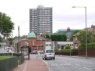
Felling is an eastern suburb of Gateshead, Tyne and Wear, England. The town was formed when three villages coalesced in the 19th century. Historically part of County Durham, the town was subsumed into the metropolitan borough of Gateshead in 1974. It lies on the B1426 Sunderland Road and the A184 Felling bypass, less than 1 mile (1.6 km) east of Gateshead town centre, 1 mile (1.6 km) south east of Newcastle-upon-Tyne and 10 miles north west of the City of Sunderland. In 2011, Felling had a population of 8,908.

Tyne Bridge was a parliamentary constituency in the north east of England, represented in the House of Commons of the Parliament of the United Kingdom, from 1983 until 2010. It elected one Member of Parliament (MP) by the first past the post system of election.
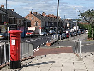
Deckham is a residential suburb in the Metropolitan Borough of Gateshead in Tyne and Wear, England. It is bordered by Gateshead town centre to the north, Sheriff Hill to the south, Felling and Carr Hill to the east and Shipcote to the west. It lies on the B1296, the route of the old Great North Road, 1 mile (1.6 km) south of Gateshead town centre, 1.5 miles (2.4 km) south of Newcastle-upon-Tyne and 13 miles (21 km) north of the city of Durham. In 2011, Deckham had a population of 9,938.
Professor Robin McInnes OBE is an English chartered geologist and chartered civil engineer who is an authority on coastal management and ground instability problems; he lives and works on the Isle of Wight, UK. He is a Visiting Professor at the Department of Geography & Environment, University of Southampton. He is also a Fellow of the Institution of Civil Engineers, the Geological Society of London, the Royal Geological Society and the Royal Society of Arts.
Newcastle High School for Girls is an independent day school for girls aged 3–18 in Newcastle upon Tyne, England. The Junior School is at Sandyford Park and the Senior School is located in the neighbouring suburb of Jesmond.

The Quayside is an area along the banks (quay) of the River Tyne in Newcastle upon Tyne and Gateshead in Tyne and Wear, North East England, United Kingdom.

Gateshead College is a further education college in the town of Gateshead, England. Established on November 15, 1955 at Durham Road in Low Fell, Gateshead. It was opened by the Duke of Edinburgh. The original campus was closed as part of a planned move in January 2008. The college moved into a £39 million new main site located at the Baltic Quayside in Gateshead. Also opened during the move was the Academy for Sport based at Gateshead International Stadium and in Team Valley the Skills Academy for Automotive, Engineering, Manufacturing and Logistics. Also in Team Valley, the Skills Academy for Construction opened in summer 2008.

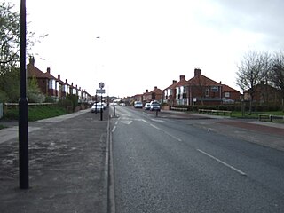
Low Fell is a suburb of Gateshead situated in the Metropolitan Borough of Gateshead in Tyne and Wear, England. Built predominantly on sandstone, grindstone and clay, it is bordered by Sheriff Hill/Deckham to the east, Saltwell/Bensham to the west, Harlow Green to the south and Shipcote to the north. The suburb lies on a major bus route 2.5 miles south of Gateshead centre, 3 miles south of the city of Newcastle upon Tyne and 12 miles north of the historic City of Durham. The principal road in the suburb is the A167. According to the 2001 UK census, the suburb had a population of 8,643, falling marginally to 8,636 at the 2011 census.
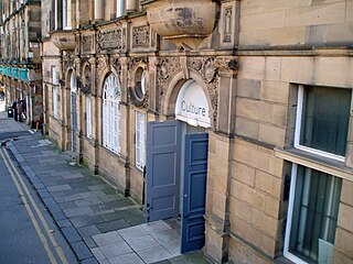
Culture Lab is an interdisciplinary research facility at Newcastle University, Newcastle upon Tyne, UK.

Newcastle City Centre is the city centre district of Newcastle upon Tyne, England. It is the historical heart of the city and serves as the main cultural and commercial centre of the North East England region. The city centre forms the core of the Tyneside conurbation.
Milecastle 1 was a milecastle of the Roman Hadrian's Wall. It was located near the valley of Stott's Pow. Its remains are covered over, and are located beneath the recreation ground at Miller's Dene. Early excavations and investigations of Turret 0B were mistakenly interpreted as Milecastle 1. The Milecastle sits within the parish of Wallsend.
Lisa-Marie Shillito is a British archaeologist and senior lecturer in landscape archaeology as well as director of the Wolfson Archaeology Laboratory and Earthslides at Newcastle University. Her practical work focuses on using soil micromorphology, phytolith analysis and geochemistry in order to understand human behaviour and landscape change. Her work includes the Neolithic settlements of Çatalhöyük in Turkey and Ness of Brodgar and Durrington Walls in Britain, but also Crusader castles and medieval settlements in Poland and the Baltic and in the Near East.