The Delaware, Lackawanna and Western Railroad, also known as the DL&W or Lackawanna Railroad, was a U.S. Class 1 railroad that connected Buffalo, New York, and Hoboken, New Jersey, and by ferry with New York City, a distance of 395 miles (636 km). The railroad was incorporated in Pennsylvania in 1853, and created primarily to provide a means of transport of anthracite coal from the Coal Region in Northeast Pennsylvania to large coal markets in New York City. The railroad gradually expanded both east and west, and eventually linked Buffalo with New York City.
The Morris and Essex Railroad was a railroad across northern New Jersey, later part of the main line of the Delaware, Lackawanna and Western Railroad.

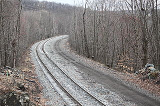
The Lackawanna Cut-Off was a rail line built by the Delaware, Lackawanna and Western Railroad (DL&W). Constructed from 1908 to 1911, the line was part of a 396-mile (637 km) main line between Hoboken, New Jersey, and Buffalo, New York. It ran west for 28.45 miles (45.79 km) from Port Morris Junction in Port Morris, New Jersey, near the south end of Lake Hopatcong about 45 miles (72 km) west-northwest of New York City, to Slateford Junction in Slateford, Pennsylvania near the Delaware Water Gap.

Lake Hopatcong is a commuter railroad station for New Jersey Transit. The station, located in the community of Landing in Roxbury Township, Morris County, New Jersey, United States, serves trains for the Montclair-Boonton Line and Morristown Line at peak hours and on holiday weekends. Service from Lake Hopatcong is provided to/from Hackettstown to New York Penn Station and Hoboken Terminal. The stop is located on the tracks below Landing Road next to the eponymous Lake Hopatcong. The station consists of one active platform with shelter, and an abandoned side platform. There is no accessibility for handicapped people.

Netcong is an NJ Transit station in Netcong, in Morris County, New Jersey, United States. Located on Route 46 at Main Street in downtown Netcong, the small, 1-low level side platform station service passengers for the Morristown Line and the Montclair-Boonton Line. These lines provide service to Hoboken or to New York City via Midtown Direct on the Morristown Line at Dover station and Montclair-Boonton at Montclair State University station. Midtown Direct service can also be transferred at Newark Broad Street station in Newark. There is one track and one platform on the north side, adjacent to the station. NJ Transit maintains a substantial train servicing yard east of the Netcong station at Port Morris in Roxbury Township. Port Morris Yard is proposed to return as the junction of the Montclair-Boonton and Morristown lines for the Lackawanna Cut-Off line to Scranton. Transfers would be provided at Lake Hopatcong station in Landing.

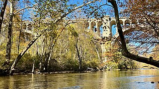
The Paulinskill Viaduct, also known as the Hainesburg Viaduct, is a reinforced concrete railroad bridge that crosses the Paulins Kill in Knowlton Township, New Jersey. When completed in 1910, it was the largest reinforced concrete structure in the world.
The Sussex Railroad was a short-line railroad in northwestern New Jersey. It replaced its predecessor, the Sussex Mine Railroad, in 1853 and operated under the Sussex Railroad Company until 1945 when it was fully merged into the Delaware, Lackawanna and Western Railroad (DL&W) system. The Sussex Railroad was important in the economic development of Sussex County as it supplied a route for early local industries, such as dairy farms and ore mines, to export their products. It was the last independently operated New Jersey railroad to be incorporated into the DL&W system. The last train travelled on the Sussex Railroad tracks on October 2, 1966. The tracks were removed soon after and the right-of-way was transformed into a rail trail known as the Sussex Branch Trail.

The Landing Masonry Bridge, also designated Bridge 44.53, is a 136-foot (41 m) stone structure built in 1907 by the Delaware, Lackawanna and Western Railroad in Landing, New Jersey, United States. Located 44.53 miles up the rail line from Hoboken Terminal, the bridge carries the two-lane Morris County Route 631 over the Morristown Line and Montclair-Boonton Line railroad tracks maintained by New Jersey Transit, and sits several hundred feet north of NJT's Lake Hopatcong Station. By 2009, it was deteriorated and structurally deficient, and plans were announced for it to be replaced with a four-lane bridge by NJT and the New Jersey Department of Transportation.

Port Morris Junction is the railroad connection between NJ Transit's Montclair-Boonton Line and the Lackawanna Cut-Off. Opened in 1911 by the Lackawanna Railroad, it is in the Port Morris, New Jersey section of Roxbury Township, New Jersey, south of Lake Hopatcong.

Roseville Tunnel is a 1,024-foot (312 m) two-track railroad tunnel on the Lackawanna Cut-Off in Byram Township, Sussex County, New Jersey. The tunnel is on a straight section of railroad between mileposts 51.6 and 51.8 (83 km), about 6 miles (9.7 km) north by northwest of Port Morris Junction. Operated for freight and passenger service from 1911 to 1979, it is undergoing work intended to return it to passenger service by 2026.

The Pequest Fill is a three-mile (4.8 km) railroad embankment in northwestern New Jersey completed in 1911 by the Delaware, Lackawanna and Western Railroad. Part of the Lackawanna Cut-Off, it was touted as the largest fill and the highest embankment ever built for a railroad.

The Lackawanna Cut-Off Restoration Project is a New Jersey Transit and Amtrak effort to restore passenger service to the Lackawanna Cut-Off in northwest New Jersey.

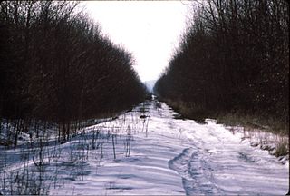
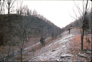
Waltz & Reece Cut is the deepest cut on the Lackawanna Cut-Off railroad line in northwest New Jersey. The cut is 0.68 miles (1.09 km) long, has an average depth of 37 feet (11 m), and a maximum depth of 114 feet (35 m).

Bradbury Fill is one of the embankments on the Lackawanna Cut-Off railroad line in northwest New Jersey. It was built from 1908 to 1911 by Waltz & Reece Construction Company. It sits between mileposts 49.1 and 49.8 in Byram Township, just west of Waltz & Reece Cut and east of Lubber Run Fill.

Lubber Run Fill is a fill on the Lackawanna Cut-Off railroad line in northwest New Jersey. Located between mileposts 50.1 and 50.5 in Byram Township, it was built between 1908 and 1911 by contractor Waltz & Reece Construction Company. It is 0.40 miles (0.64 km) long, has an average height of 64 feet, and a maximum height of 98 feet. Most of its 720,000 cubic yards (550500 m3) of fill material was excavated from the surrounding low-lying area.

Wharton Fill is one of a number of fills (embankments) on the Lackawanna Cut-Off railroad line in northwest New Jersey. Located between mileposts 51.1 and 51.6 in Byram Township, the fill was constructed between 1908 and 1911 by contractor David W. Flickwir. The fill, which was created by placing fill material obtained by blasting with dynamite or other methods, is about 0.5 miles (0.64 km) long. Most of the material that was used to create Wharton Fill was excavated from the surrounding low-lying area through which Pumpkin Run runs; several of the borrow pits have since flooded and become ponds.

Colby Cut is one of a number of cuts on the Lackawanna Cut-Off railroad line in northwest New Jersey. Located between approximately mileposts 51.8 and 52.3 in Byram Township, the cut was constructed between 1908 and 1911 by contractor David W. Flickwir. The cut, which was created by removing fill material obtained by blasting with dynamite or other methods, is 0.53 miles (0.85 km) long, has an average depth of 45 feet (14 m), and a maximum depth of 110 feet (34 m). The cut was the result of the removal of 462,342 cubic yards of fill material within this section.

Andover is a planned New Jersey Transit passenger railroad station in Andover Township, in Sussex County, New Jersey, United States, providing service on its Lackawanna Cut-Off line. The line remains under construction. The station will be built at a site on Andover's Roseville Road, about 1.1 miles (1.8 km) from U.S. Route 206 and about 0.9 miles (1.4 km) from County Route 517. On the rail line, it will be located about 7.3 miles (11.7 km) west of Port Morris Junction.

Armstrong Cut is one of the largest cuts on the Lackawanna Cut-Off railroad line in northwest New Jersey. Located between approximately mileposts 61.4 and 62.3 in Frelinghuysen Township, the cut was constructed between 1908 and 1911 by contractor Hyde, McFarlan & Burke. The cut, which was created by removing fill material obtained by blasting with dynamite or other methods, is 0.89 miles (1.43 km) long, has an average depth of 52 feet (16 m), and a maximum depth of 104 feet (32 m). The fill was created as a result of the removal of 852,000 cubic yards of fill material from this section of the right-of-way. Armstrong Cut is located on a tangent (straight) section of track, permitting 80 mph (130 km/h).
The Waltz & Reece Construction Company was a construction company that operated in the first quarter of the 20th century, best known for its work on the Lackawanna Cut-off in New Jersey.


