Route 7 is a state highway in the northern part of New Jersey in the United States. It has two sections, an east–west alignment running from U.S. Route 1/9 Truck in Jersey City to the Passaic River in Belleville, and a north–south alignment running from the Newark/Belleville to the Nutley/Clifton border. The New Jersey Department of Transportation (NJDOT) lists Route 7 as a single north–south highway with a small gap between the alignments. The entire highway has a combined length of 9.46 mi (15.22 km).

Route 139 is a state highway in Jersey City, New Jersey in the United States that heads east from the Pulaski Skyway over Tonnele Circle to the state line with New Jersey and New York in the Holland Tunnel, which is under the Hudson River, to New York City. The western portion of the route is a two-level highway that is charted by the New Jersey Department of Transportation (NJDOT) as two separate roadways: The 1.45-mile (2.33 km) lower roadway (Route 139) between U.S. Route 1/9 (US 1/9) over Tonnele Circle and Interstate 78 (I-78) at Jersey Avenue, and the 0.83-mile (1.34 km) upper roadway running from County Route 501 and ending where it joins the lower highway as part of the 12th Street Viaduct, which ends at Jersey Avenue. The lower roadway is listed on the federal and NJ state registers of historic places since 2005. The eastern 1.32 miles (2.12 km) of the route includes the Holland Tunnel approach that runs concurrent with Interstate 78 on the one-way pair of 12th Street eastbound and 14th Street westbound. Including the concurrency, the total length of Route 139 is 2.77 miles (4.46 km).

The Pulaski Skyway is a four-lane bridge-causeway in the northeastern part of the U.S. state of New Jersey, carrying a freeway designated U.S. Route 1/9 (US 1/9) for most of its length. The structure has a total length of 3.502 miles (5.636 km). Its longest bridge spans 550 feet (168 m). Traveling between Newark and Jersey City, the roadway crosses the Passaic and Hackensack rivers, Kearny Point, the peninsula between them, and the New Jersey Meadowlands.

The Hudson–Bergen Light Rail (HBLR) is a light rail system in Hudson County, New Jersey, United States. Owned by New Jersey Transit (NJT) and operated by the 21st Century Rail Corporation, it connects the communities of Bayonne, Jersey City, Hoboken, Weehawken, Union City, at the city line with West New York, and North Bergen.
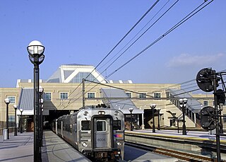
Secaucus Junction is an intermodal transit hub served by New Jersey Transit and Metro-North Railroad in Secaucus, New Jersey. It is one of the busiest railway stations in North America.

U.S. Route 1/9 Truck is a United States Numbered Highway in the northern part of New Jersey that stretches 4.11 miles (6.61 km) from the eastern edge of Newark to the Tonnele Circle in Jersey City. It is the alternate route for US 1/9 that trucks must use because they are prohibited from using the Pulaski Skyway, which carries the main routes of US 1/9. It also serves traffic accessing the New Jersey Turnpike, Route 440, and Route 7. The route is a four- to six-lane road its entire length, with portions of it being a divided highway that runs through urban areas. From its south end to about halfway through Kearny, US 1/9 Truck is a freeway, with access to other roads controlled by interchanges.

The New Jersey Department of Transportation (NJDOT) is the agency responsible for transportation issues and policy in New Jersey, including maintaining and operating the state's highway and public road system, planning and developing transportation policy, and assisting with rail, freight, and intermodal transportation issues. It is headed by the Commissioner of Transportation. The present acting commissioner is Francis K. O'Connor.

Interstate 280 (I-280) is a 17.85-mile (28.73 km) Interstate Highway in the U.S. state of New Jersey. It provides a spur from I-80 in Parsippany–Troy Hills, Morris County, east to Newark and I-95 in Kearny, Hudson County. In Kearny, access is provided toward the Holland Tunnel and Lincoln Tunnel to New York City. The western part of the route runs through suburban areas of Morris and Essex counties, crossing the Watchung Mountains. Upon reaching The Oranges, the setting becomes more urbanized and I-280 runs along a depressed alignment before ascending again in Newark. I-280 includes a vertical-lift bridge, the William A. Stickel Memorial Bridge, over the Passaic River between Newark and East Newark/Harrison. The highway is sometimes called the Essex Freeway. I-280 intersects several roads, including the Garden State Parkway in East Orange and Route 21 in Newark.

The New Jersey Meadowlands Commission was a regional zoning, planning and regulatory agency in northern New Jersey. Its founding mandates were to protect the delicate balance of nature, provide for orderly development, and manage solid waste activities in the New Jersey Meadowlands District. The Commission operated as an independent state agency between 1969 and 2015, loosely affiliated with the New Jersey Department of Community Affairs. In 2015 NJMC was merged with the New Jersey Sports and Exposition Authority (NJSEA) through legislative action.

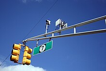
The Wittpenn Bridge is a vertical-lift bridge that carries New Jersey Route 7 over the Hackensack River in Jersey City and Kearny, in Hudson County, New Jersey. It is named after H. Otto Wittpenn, a former mayor of Jersey City. The bridge has an annual average daily traffic (AADT) of nearly 50,000 vehicles, including about 2,000 trucks. In 2005, the bridge was raised 80 times to accommodate boats passing underneath. The original span opened in 1930; its replacement opened in 2021.

U.S. Route 1 (US 1) is a U.S. Route which parallels the East Coast of the United States, running from Key West, Florida, in the south to Fort Kent, Maine, at the Canadian border in the north. Of the entire length of the route, 66.06 miles (106.31 km) of it runs through New Jersey. It enters the state from Pennsylvania on the Trenton–Morrisville Toll Bridge over the Delaware River in the state capital of Trenton, running through the city on the Trenton Freeway. From here, US 1 continues northeast as a surface divided highway through suburban areas, heading into Middlesex County and passing through New Brunswick and Edison. US 1 merges with US 9 in Woodbridge, and the two routes continue through northern New Jersey as US 1/9 to the George Washington Bridge over the Hudson River in Fort Lee. At this point, the road continues into New York City along with Interstate 95.

Bayfront is an urban redevelopment project in Jersey City, New Jersey.

The normal function of traffic lights requires more than sight control and coordination to ensure that traffic and pedestrians move as smoothly, and safely as possible. A variety of different control systems are used to accomplish this, ranging from simple clockwork mechanisms to sophisticated computerized control and coordination systems that self-adjust to minimize delay to people using the junction.
Adaptive traffic control system (ATCS) is a traffic management strategy in which traffic signal timing changes, or adapts, based on actual traffic demand. This is accomplished using an adaptive traffic control system consisting of both hardware and software.

Bus rapid transit (BRT) in New Jersey comprises limited-stop bus service, exclusive bus lanes (XBL) and bus bypass shoulders (BBS). Under the banner Next Generation Bus NJ Transit (NJT), the New Jersey Department of Transportation (NJDOT), and the metropolitan planning organizations of New Jersey (MPO) which recommend and authorize transportation projects are undertaking the creation of several additional BRT systems in the state.
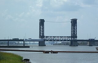
The Lincoln Highway Hackensack River Bridge is a vehicular vertical lift bridge crossing the Hackensack River at a point 1.8 mi (2.9 km) from the river mouth at Newark Bay in Hudson County, New Jersey, United States. The bridge, along the route of the Lincoln Highway, carries U.S. Route 1/9 Truck and the East Coast Greenway between the West Side of Jersey City and Kearny Point in Kearny. The most recent of many crossings at the location, the current bridge was completed in 1954. It is owned by and operated by the New Jersey Department of Transportation (NJDOT), and is required by the Title 33 of the Code of Federal Regulations to open on signal for maritime traffic. In 2007 it was designated the Shawn Carson and Robert Nguyen Memorial Bridge.

The Lincoln Highway Passaic River Bridge is a vehicular moveable bridge crossing the Passaic River at a point 1.8 mi (2.9 km) from the river mouth at Newark Bay in northeastern New Jersey, United States. The vertical lift bridge, along the route of the Lincoln Highway, carries U.S. Route 1/9 Truck and the East Coast Greenway between the Ironbound section of Newark and Kearny Point in Kearny. Opened in 1941, it is owned by and operated by the New Jersey Department of Transportation (NJDOT) and required by the Code of Federal Regulations to open on 4-hour notice for maritime traffic.

The Mass Transit Super Bowl was a public transportation plan and marketing strategy conceived for Super Bowl XLVIII and Super Bowl Week, a series of events leading up to the February 2, 2014, football game between the Denver Broncos and the Seattle Seahawks. It was originally projected that over 400,000 people would come to the New York–New Jersey region for the game and related activities, and that over 80,000 would attend the game itself; actual patronage of the metropolitan area during that time was projected to be over 500,000. Metropolitan area transit agencies worked with the National Football League, organizers of the event, and developed special services, schedules, fares, and maps to promote the use of mass transit during the week, which began with the arrival of teams on January 26.

The Chaplain Washington Bridge and the Harry Laderman Bridge, or the Chaplain Washington Memorial Bridge and Laderman Memorial Bridge, are a pair of bridges on the New Jersey Turnpike crossing the Passaic River in northeastern New Jersey. The Washington Bridge built in 1952 and carries the eastern spur of the turnpike; the Laderman Bridge was built in 1970 and carries the western spur.