Last updated • 1 min readFrom Wikipedia, The Free EncyclopediaView of sea and lighthouse
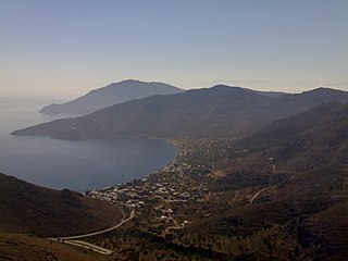
Cape Megalo Embolo (Greek: Μεγάλο έμβολο, 'Great Point') or Karaburnu (Turkish 'Black Cape'), probably the ancient Aeneium or Aineion (Ancient Greek: Αἰνειῶν), is a cape southwest of Thessaloniki, Greece, located next to the village of Angelochori. There is a lighthouse.
The line from Megalo Embolo to the mouth of the Vardar/Axios is sometimes considered to define the entrance of the Thermaic Gulf.[1]
It appears to correspond to the promontory of Aeneium described in the Periodos to Nicomedes of Pseudo-Scymnus, and was probably the site of the ancient city of Aenea.
The smaller cape Karabournaki, Mikro Karabournou, or Mikro Emvolo is found to its northeast.
Notes
↑ Malamut Elisabeth, Grélois Jean-Pierre, "Le port de Thessalonique (IVe-XVIe siècles)", Actes des congrès de la Société des historiens médiévistes de l'enseignement supérieur public35:131-147, La Rochelle, 2004. "Ports maritimes et ports fluviaux au Moyen Age." doi:10.3406/shmes.2004.1875full text
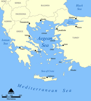
The Aegean Sea is an elongated embayment of the Mediterranean Sea between Europe and Asia. It is located between the Balkans and Anatolia, and covers an area of some 215,000 km2 (83,000 sq mi). In the north, the Aegean is connected to the Marmara Sea, which in turn connects to the Black Sea, by the straits of the Dardanelles and the Bosphorus, respectively. The Aegean Islands are located within the sea and some bound it on its southern periphery, including Crete and Rhodes. The sea reaches a maximum depth of 3,544 m (11,627 ft) to the east of Crete. The Thracian Sea and the Sea of Crete are main subdivisions of the Aegean Sea.
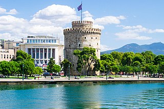
Thessaloniki, also known as Thessalonica, Saloniki, Salonika, or Salonica, is the second-largest city in Greece, with slightly over one million inhabitants in its metropolitan area, and the capital of the geographic region of Macedonia, the administrative region of Central Macedonia and the Decentralized Administration of Macedonia and Thrace. It is also known in Greek as "η Συμπρωτεύουσα", literally "the co-capital", a reference to its historical status as the Συμβασιλεύουσα or "co-reigning" city of the Byzantine Empire alongside Constantinople.
The Ionian Sea is an elongated bay of the Mediterranean Sea. It is connected to the Adriatic Sea to the north, and is bounded by Southern Italy, including Basilicata, Calabria, Sicily, and the Salento peninsula to the west, southern Albania to the north, and the west coast of Greece, including the Peloponnese.
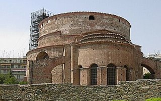
The Arch of Galerius or Kamara (Καμάρα) and the Rotunda (Ροτόντα) are neighbouring early 4th-century AD monuments in the city of Thessaloniki, in the region of Central Macedonia in northern Greece. As an outstanding example of early Byzantine art and architecture, in addition to the importance of the Rotunda as one of the earliest Christian monuments in the Eastern Roman Empire, both sites were inscribed on the UNESCO World Heritage List in 1988 as part of the Paleochristian and Byzantine monuments of Thessaloniki.
Vouliagmeni is a seaside suburb and former municipality 20 km south of Athens city centre. Since the 2011 local government reform it is part of the municipality Vari-Voula-Vouliagmeni, of which it is a municipal unit. The municipal unit has an area of 5.805 km2. Its population was 4,332 at the 2021 census. In 1993 and again in 2009, it hosted the annual meeting of the Bilderberg Group. The suburb is named after Lake Vouliagmeni, located in its vicinity. It is one of the most prestigious Athenian suburbs, home to renowned hotels and beaches. The area has some of the highest real estate prices in the Balkans.
Tílos is a small Greek island and municipality located in the Aegean Sea. It is part of the Dodecanese group of islands, and lies midway between Kos and Rhodes. In 2021, the island had a population of 746 people. Along with the uninhabited offshore islets of Antitilos and Gaidaros, it forms the Municipality of Tilos, which has a total land area of 64.525 square kilometres (24.913 sq mi). Tilos is part of the Rhodes regional unit.
The Thermaic Gulf, also called the Gulf of Thessaloniki and the Macedonian Gulf, is a gulf constituting the northwest corner of the Aegean Sea. The city of Thessaloniki is at its northeastern tip, and it is bounded by Pieria Imathia and Larissa on the west and the Chalkidiki peninsula on the east, with Cape Kassandra at the southeasternmost corner. It is named after the ancient town of Therma, modern Thessaloniki. It is about 100 km (62 mi) long.
Mikro Emvolo, also called Karabournaki (Καραμπουρνάκι), is the cape of Kalamaria in northeastern Thessaloniki and a district of the local municipality. Its name comes from kara burun in Turkish, meaning 'black peninsula'. + Greek -aki (diminutive).
Agathonísi is a small Greek island and municipality located at the northernmost point of the Dodecanese in Greece. It is surrounded by many smaller islands and is home to two villages, both inland; Megalo Chorio, and Mikro Chorio. Between them is the small settlement of Agios Georgios, which forms the island's only harbor and consists of a few hotels and restaurants. The island is also locally known as Gaidaro ("Donkey"), or by its ancient name Tragea.
Rodolivos is a town and a former municipality in the Serres regional unit, Greece. Since the 2011 local government reform it is part of the municipality Amfipoli, of which it is the seat and a municipal unit. The municipal unit has an area of 106.034 km2. It is about 30 km from Drama. Its population was 2,002 in 2021. The village is at the foot of Mount Pangaio.
Angelochori is a village in the municipal unit of Thermaikos, in the Thessaloniki regional unit, Greece. It is located to the east of Cape Megalo Embolo, at an average elevation of 16 meters above the sea level.
Toxotes is a settlement and a community in the Xanthi regional unit of Greece, part of the municipality Topeiros. It is located approximately 13.9 kilometers from Xanthi and 1 kilometer east of the river Nestos. In 2021, the population was 1,484 for the community. In 1981, the population of the settlement was around 2,198 inhabitants. In 1991, the number of people in Toxotes dropped to 802 inhabitants. The community consists of the settlements Toxotes, Agios Athanasios, Thalassia, Kosmiti, Megalo Tympano, Mikro Tympano, Poimni and Semeli.
Aenea was an ancient Greek city in northwesternmost Chalcidice, said to have been founded by Aeneas, and was situated, according to Livy, opposite Pydna, and 15 miles from Thessalonica. It appears to have stood on the promontory of Megalo Embolo, which forms the northwest corner of the peninsula of Chalcidice, and which, being about 10 geographical miles in direct distance from Thessalonica, may be identified with the promontory Aeneium of Pseudo-Scymnus. Aeneia must therefore have been further north than Pydna. It was colonised by the Corinthians. It is mentioned by Herodotus, and continued to be a place of importance down to the time of the Roman wars in Greece, although we are told that a great part of its population was removed to Thessalonica, when the latter city was founded by Cassander. The city minted coins in antiquity, some of which survive today.
Oricum was a harbor on the Illyrian coast that developed in an Ancient Greek polis at the south end of the Bay of Vlorë on the southern Adriatic coast. It was located at the foot of the Akrokeraunian Mountains, the natural border between ancient Epirus and Illyria. Oricum later became an important Roman city between the provinces of Epirus Vetus and Epirus Nova in Macedonia. It is now an archaeological park of Albania, near modern Orikum, Vlorë County. Oricum holds such a strategic geographical position that the area has been in continuous usage as a naval base from antiquity to the present-days.
Tamentfoust, the classical Rusguniae and colonial La Pérouse, is a site in the Dar El Beïda District of Algiers in Algeria.
Karaburun is a district and the center town of the same district of İzmir Province, Turkey.
Ladadika is the name of a historic district and a landmark area of the city of Thessaloniki, Greece.
Northern Greece Naval Command, formerly the Northern Aegean Naval Command, is a regional command of the Hellenic Navy covering the coasts of northern Greece and the northern Aegean Sea, from the Greco-Turkish border at the mouth of the river Evros to Mount Pelion.
Mikro Souli is a semi-mountainous village in Serres regional unit of Central Macedonia, Greece, located 60 km southeast of the city of Serres. Since the 2011 local government reform it is a part of the municipality of Amphipolis. It has a population of 334 inhabitants (2021). Its former name was "Semalto"
Embolos was a town of ancient Bithynia, inhabited during Roman times.
This page is based on this Wikipedia article Text is available under the CC BY-SA 4.0 license; additional terms may apply. Images, videos and audio are available under their respective licenses.