
The 1811–1812 New Madrid earthquakes were a series of intense intraplate earthquakes beginning with an initial earthquake of moment magnitude 7.2–8.2 on December 16, 1811, followed by a moment magnitude 7.4 aftershock on the same day. Two additional earthquakes of similar magnitude followed in January and February 1812. They remain the most powerful earthquakes to hit the contiguous United States east of the Rocky Mountains in recorded history. The earthquakes, as well as the seismic zone of their occurrence, were named for the Mississippi River town of New Madrid, then part of the Louisiana Territory and now within the U.S. state of Missouri.

The New Madrid Seismic Zone, sometimes called the New Madrid Fault Line, is a major seismic zone and a prolific source of intraplate earthquakes in the Southern and Midwestern United States, stretching to the southwest from New Madrid, Missouri.

The 1886 Charleston earthquake occurred about 9:50 p.m. local time August 31. It caused 60 deaths and $5–6 million in damage to 2,000 buildings in the Southeastern United States. It is one of the most powerful and damaging earthquakes to hit the East Coast of the United States.
The 1950 Assam–Tibet earthquake, also known as the Assam earthquake, occurred on 15 August and had a moment magnitude of 8.6. The epicentre was located in the Mishmi Hills in India, known in Chinese as the Qilinggong Mountains (祁灵公山), south of the Kangri Karpo and just east of the Himalayas in the North-East Frontier Agency part of Assam, India. This area, south of the McMahon Line and now known as Arunachal Pradesh, is today disputed between China and India. It is the strongest earthquake ever recorded on land.
The 1930 Salmas earthquake occurred on in West Azerbaijan Province, Iran. The earthquake, which was among Iran's largest, measured 7.1 on the moment magnitude scale and had a maximum Mercalli intensity of IX (Violent). A damaging foreshock occurred fifteen hours prior to the main event and served as a warning to the people that felt it strongly. Reports from seismologists and seismological organizations indicate that up to 3,000 fatalities may have occurred in northwest Iran and southeast Turkey.
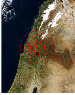
The Galilee earthquake of 1837, often called the Safed earthquake, shook the Galilee on January 1 and is one of a number of moderate to large events that have occurred along the Dead Sea Transform (DST) fault system that marks the boundary of two tectonic plates; the African Plate on the west and the Arabian Plate on the east. Intensity assessments for the event were VIII (Damaging) on the Medvedev–Sponheuer–Karnik scale and VIII on the European Macroseismic Scale.

The 856 Damghan earthquake or the 856 Qumis earthquake occurred on 22 December 856. The earthquake had an estimated magnitude of 7.9, and a maximum intensity of X (Extreme) on the Mercalli intensity scale. The meizoseismal area extended for about 350 kilometres (220 mi) along the southern edge of the eastern Alborz mountains of present-day Iran including parts of Tabaristan and Gorgan. The earthquake's epicenter is estimated to be close to the city of Damghan, which was then the capital of the Persian province of Qumis. It caused approximately 200,000 deaths and is listed by the USGS as the sixth deadliest earthquake in recorded history. This death toll has been debated.
The 1879 Gansu earthquake occurred at about 04:00 local time on 1 July. It had an estimated magnitude of 8.0 on the scale and a maximum perceived intensity of XI (Extreme) on the Mercalli intensity scale. The epicenter was in Wudu District in southern Gansu, close to the border with Sichuan. It caused widespread damage and killed an estimated 22,000 people.
On November 2 of 1946, west Kyrgyzstan was struck by a magnitude 7.5-7.6 earthquake, the largest in the republic since 1911. The earthquake's hypocenter is probably located beneath the Tian Shan Mountains, near the border with Uzbekistan and north of Namangan.
The 1986 Kalamata earthquake struck the southern Peloponnese Region of Greece on September 13 at 20:24 local time. The moment magnitude 6.0 or surface-wave magnitude 6.2 earthquake had an epicenter located near the coastal city of Kalamata. It was assigned X (Extreme) on the Modified Mercalli intensity scale caused by extensive damage in Kalamata. At least 20 people died and approximately 300 were injured.
The 1889 Chilik earthquake occurred on July 11 on the Gregorian calendar, or June 30 on the Julian calendar at 15:14 local time in the Tien Shan mountains. The earthquake measured an estimated Mw 7.9–8.0 on the moment magnitude scale and was assigned a maximum intensity of X (Devastating) on the MSK 64 and Rossi-Forel scales. Over 92 people across Kazakhstan, Kyrgyzstan and China were killed.
The 1904 Kresna earthquakes occurred on the same day of April 4 in the Ottoman Empire. The pair of earthquakes measured 6.9 and 7.2 on the surface wave magnitude scale, and were assigned the respective Modified Mercalli intensity scale ratings of X (Extreme) and XI (Extreme). More than 200 people were killed in the two earthquakes. Several villages were obliterated as a result.
The 1984 Cachar earthquake rattled much of Southern Assam on December 31, 1984, at 5:03 a.m. (UTC+5:30) with an epicenter 20 kilometers southwest of Lakhipur. The quake measured with a magnitude of 6.0 on the moment magnitude scale and an estimated intensity of VIII (Severe) on the Modified Mercalli intensity scale. About 20 people died and 100 others sustained mild to severe injuries.
The 1923 Renda earthquake occurred on March 24 at 20:40 local time between the counties of Daofu and Luhuo in Sichuan, China. The estimated 7.3 earthquake was assigned a maximum modified Mercalli intensity scale rating of X (Extreme). Severe damage occurred in Sichuan, killing an estimated 4,800 people.

The 1887 Verny earthquake occurred on June 8 at 04:35 local time in the Turkestan region of present-day Kazakhstan. It had an epicenter in the northern foothills of the Trans-Ili Alatau mountain range, or just south of the city of Verny,. This earthquake destroyed the city of Verny, killing at least 330 people. A moment magnitude of 7.3–7.7 and MSK 64 intensity of X (Devastating) has been estimated for the earthquake.
The 1879 Surigao earthquake occurred on June 30 at 18:38 02:55 local time on the northeastern tip of Mindanao. The earthquake with a moment magnitude (Mw ) of 7.4 struck with an epicenter just south of Lake Mainit. Extensive damage occurred but there were no reports of casualties.
On December 5, the largest earthquake to occur on the Italian Peninsula struck the Kingdom of Naples. The earthquake had an estimated moment magnitude of 7.19–7.4 Mw , and nucleated near the town of Pontelandolfo in present-day Province of Benevento, central Italy. Earning a level of XI (Extreme) on the Modified Mercalli intensity scale, the earthquake caused widespread destruction in central and southern Italy. An estimated 30,000–70,000 people were killed. It was followed by two strong Mw 7.0 and 6.0 earthquakes to the north on December 30.
The 1997 Bojnurd earthquake occurred on February 4 at 14:07 IRST, near the Turkmenistan-Iran border region. The epicenter of the Mw 6.5 earthquake was the Kopet Dag mountains of North Khorasan province. With a maximum Modified Mercalli intensity of VIII (Severe), the event resulted in at least 88 fatalities, 1,948 injuries, and severe damage in the cities of Shirvan and Bojnord. At least 173 villages were affected; three were destroyed. The total cost of damage was estimated at $US 30 million.
The 1895 Charleston earthquake, also known as the Halloween earthquake occurred on October 31, at 05:07 CST near Charleston, Missouri. It had an estimated moment magnitude of 5.8–6.6 and evaluated Modified Mercalli intensity of VIII (Severe). The earthquake caused substantial property damage in the states of Missouri, Illinois, Ohio, Alabama, Iowa, Kentucky, Indiana, Tennessee. Shaking was widespread, being felt across 23 states and even in Canada. At least two people died and seven were injured.