
Cass County is a county located in the western part of the U.S. state of Missouri and is part of the Kansas City metropolitan area. As of the 2020 census, the population was 107,824. Its county seat is Harrisonville, however the county contains a portion of Kansas City, Missouri. The county was organized in 1835 as Van Buren County, but was renamed in 1849 after U.S. Senator Lewis Cass of Michigan, who later became a presidential candidate.
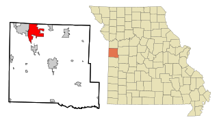
Raymore is a city in Cass County, Missouri, United States, within the Kansas City Metropolitan Area. Raymore is one of the fastest-growing cities in the state of Missouri. The population was 21,676 at the 2020 census.

The Memorial area of Houston, Texas is located west of Downtown, northwest of Uptown, and south of Spring Branch. The Memorial Super Neighborhood, as defined by the City of Houston, is bounded by Buffalo Bayou to the south, Barker Reservoir to the west, the Katy Freeway to the north, and the Memorial Villages, a contiguous group of independent municipalities, to the east.

Johnny Appleseed Park, including what was formerly known as Archer Park, is a public park in Fort Wayne, Indiana. It is named after the popular-culture nickname of John Chapman, better known as "Johnny Appleseed", a famous American pioneer, who was buried on the site. Chapman's gravesite is accessible to public view through steel gates. The weathered tombstone says, "Johnny Appleseed He lived for others. 1774–1845." It also has a carved apple in bas relief.

The Steuben Memorial State Historic Site is a historic location in the eastern part of Steuben, Oneida County, New York, that honors Baron von Steuben, the "Drillmaster of the American Revolution". The land in this part of Oneida County was part of a 16,000-acre (6,500 ha) land grant made to von Steuben for his services to the United States. He used the land for his summer residence, and is buried at the memorial, a "Sacred Grove".
Highway 6 is a paved undivided major provincial highway in the Canadian province of Saskatchewan. It runs from Montana Highway 16 at the Canada–US border near the Canada customs port of Regway to Highway 55 near Choiceland. Highway 6 is about 523 km (325 mi) long. The CanAm Highway comprises Saskatchewan Highways from south to north: SK 35, Sk 39, Sk 6, Sk 3, as well as Sk 2. 330 kilometres (210 mi) of Saskatchewan Highway 6 contribute to the CanAm Highway between Corinne and Melfort.
The Raymore-Peculiar R-II School District (Ray-Pec) is a public school district in Raymore and Peculiar, Missouri, United States. It is a suburban school district in a quickly developing area, and many new students are being enrolled.

Raymore–Peculiar High School (Ray-Pec) is a public high school serving the towns of Raymore and Peculiar, parts of Lee's Summit, and some unincorporated areas of Cass County, Missouri. The school's mascot is the Panther, and the official colors are black and white, although gold has been in regular use for some time. It is also a participant in Missouri's A+ Program.

Grant Cottage State Historic Site is an Adirondack mountain cottage on the slope of Mount McGregor in the town of Moreau, New York. Ulysses S. Grant, the 18th President of the United States, died of throat cancer at the cottage on July 23, 1885. The house was maintained as a shrine to U.S. Grant following his death by the Mount McGregor Memorial Association and a series of live-in caretakers. The building became a New York State Historic Site in 1957 and was added to the National Register of Historic Places in 1971. The Historic Site was designated a National Historic Landmark by the National Park Service in 2021.
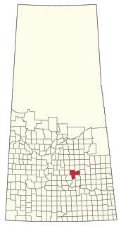
Raymore is a town in the Canadian province of Saskatchewan. Raymore is located 110 km north of Regina.
The Craig Memorial Cup, also known as the William Craig Memorial Cup is an intermediate football competition in Northern Ireland run by the North West of Ireland Football Association. The competition culminates in the final which has traditionally been played on Boxing Day. The current champions are Portstewart.

Raymore Drive is a mostly residential street in the Weston neighbourhood of Toronto in the Canadian province of Ontario. It runs next to the Humber River. On October 15, 1954, the area was severely affected by Hurricane Hazel. When the Humber River burst its banks and tore away a footbridge, the waters of the Humber were redirected through the neighbourhood. The flood killed 35 residents and washed away 39 percent of the street. The washed-away part of Raymore Drive was never rebuilt, as subsequent residential development in that area has been prohibited; it is now part of Raymore Park.

The effects of Hurricane Hazel in Canada included 81 deaths and C$137,552,400 in damages. Hazel, the deadliest and costliest storm of the 1954 Atlantic hurricane season, reached Toronto, Ontario by the evening of October 15, 1954. It peaked as a category 4 storm, but by the time it reached Canada, it was an extratropical category 1 storm after merging with an existing cold front south of Ontario. Due to an area of high pressure to the north-east, Hazel stalled over Toronto and lost most of its moisture.
The Rural Municipality of Mount Hope No. 279 is a rural municipality (RM) in the Canadian province of Saskatchewan within Census Division No. 10 and SARM Division No. 5.
Recreation Park is a public, urban park in Raymore, Missouri. Located on the southern end of Raymore, Recreation Park is bordered by South Madison Street on the West and Hubach Hill Road on the South. The park contains numerous soccer fields, a baseball complex with concessions, two shelter houses with additional concessions, walking paths, and a playground. It is also home to the Raymore Skate Park and Recreation Park Pond.
Hawk Ridge Park is a public, urban park in Raymore, Missouri. Located at 701 Johnston Parkway in Raymore, Hawk Ridge Park is largely undeveloped. The park contains a stocked lake, rolling hills, and a limited walking trail.
Raymore Township is a township in Cass County, in the U.S. state of Missouri. The township had 28,306 residents as of a 2015 estimate. The township borders Jackson County and includes the city of Raymore
