
Rondane National Park is the oldest national park in Norway, having been established on 21 December 1962. The park is located in Innlandet county, in the municipalities of Dovre, Folldal, Sel, Nord-Fron, Sør-Fron, Stor-Elvdal, and Ringebu. The park contains ten peaks above 2,000 metres (6,560 ft), with the highest being Rondeslottet at an altitude of 2,178 m (7,146 ft). The park is an important habitat for herds of wild reindeer.
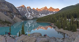
Moraine Lake is a glacially fed lake in Banff National Park, 14 kilometres (8.7 mi) outside the village of Lake Louise, Alberta, Canada. It is situated in the Valley of the Ten Peaks, at an elevation of approximately 1,884 metres (6,181 ft). The lake has a surface area of 50 hectares.

Jotunheimen is a mountainous area of roughly 3,500 square kilometres (1,400 sq mi) in southern Norway and is part of the long range known as the Scandinavian Mountains. The 29 highest mountains in Norway are all located in the Jotunheimen mountains, including the 2,469-metre (8,100 ft) tall mountain Galdhøpiggen. The Jotunheimen mountains straddle the border between Innlandet and Vestland counties.

Jotunheimen National Park is a national park in Norway, recognized as one of the country's premier hiking and fishing regions. The national park covers 1,151 square kilometres (444 sq mi) and is part of the larger area Jotunheimen. More than 250 peaks rise above an elevation of 1,900 metres (6,200 ft), including Northern Europe's two highest peaks: Galdhøpiggen at 2,469 metres (8,100 ft), and Glittertind at 2,465 metres (8,087 ft).

A mountain hut is a building located high in the mountains, generally accessible only by foot, intended to provide food and shelter to mountaineers, climbers and hikers. Mountain huts are usually operated by an Alpine Club or some organization dedicated to hiking or mountain recreation. They are known by many names, including alpine hut, mountain shelter, mountain refuge, mountain lodge, and mountain hostel. It may also be called a refuge hut, although these occur in lowland areas too.

Hardangervidda National Park, at 3,422 square kilometres (1,321 sq mi), is Norway's largest national park. It spans from Numedal and Uvdal in the east and Røvelseggi and Ullensvang in the west across the Hardanger mountain plateau (Hardangervidda). Designated as a national park in 1981, today it serves as a popular tourist destination for activities such as hiking, climbing, fishing, and cross-country skiing. The Norwegian Mountain Touring Association (DNT) maintains a comprehensive network of huts and paths across Hardangervidda. The Bergen Line and the main Highway 7 cross the plateau. The park lies in Viken, Vestland, and Vestfold og Telemark counties.

Bygdin is a lake in the southern part of the Jotunheimen mountain range. It is located in Vang municipality in Oppland, Norway.
Eidsbugarden is a tourist center which lies at the western end of Lake Bygdin in the Jotunheimen mountain range on the outskirts of Jotunheim National Park in Oppland, Norway. Eidsbugarden lies to the southeast in Jotunheim.

Gjende or Gjendin is a lake in Vågå Municipality in Innlandet county, Norway. It is located in the Jotunheimen mountain range and also inside Jotunheimen National Park. The proglacial lake shows typical characteristics of glacial formation, being long and narrow, with steep walls. The lake is 18 kilometres (11 mi) in length and only 1.5 kilometres (0.93 mi) in width at the broadest point. Gjende has a characteristic light-green color resulting from the large quantity of rock flour which is discharged into the Gjende by the Muru river. The river Sjoa provides the outlet from Gjende at Gjendesheim, and flows eastward into the Gudbrandsdalslågen river.

Øvre Sjodalsvatnet is a lake in Vågå Municipality in Innlandet county, Norway. It is located in the Jotunheimen mountain range. The lake is located on the river Sjoa, just outside the boundary of Jotunheimen National Park. The Maurvangen campground and Bessheim mountain lodge are located near the southwestern shore of the lake.
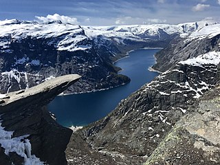
Trolltunga is a rock formation situated about 1,100 metres (3,600 ft) above sea level in Ullensvang Municipality in Vestland county, Norway. The cliff juts horizontally out from the mountain, about 700 metres (2,300 ft) above the north side of the lake Ringedalsvatnet.

Trollheimen is a mountain range in Møre og Romsdal and Trøndelag counties in central Norway. The mountain range is part of the Scandinavian Mountains.
Besseggen or Besseggi is a mountain ridge in Vågå Municipality in Innlandet county, Norway. The 1,634-metre (5,361 ft) tall mountain ridge is located in the Jotunheimen mountains within Jotunheimen National Park. The mountain sits about 46 kilometres (29 mi) southwest of the village of Vågåmo and about 30 kilometres (19 mi) northwest of the village of Beitostølen. The mountain ridge is surrounded by several other notable mountains including Veslfjellet to the east and Besshø to the northwest. The ridge runs between the lakes Gjende and Bessvatnet.
Gjendesheim Turisthytte has been a staffed lodge with Norwegian Mountain Touring Association Oslo og Omegn as proprietor since 1878, and is located in the heart of the Norwegian mountains. The lodge can accommodate 170 guests in bedrooms with 1, 2 and 4 beds and four dormitories. The standard is simple; with bunks and joint shower/WC.
Bessvatnet is a glacial lake in Vågå Municipality in Innlandet county, Norway. The 4.7-square-kilometre (1.8 sq mi) lake is located in the Jotunheimen mountain range and also inside the Jotunheimen National Park. The lake lies just east of the mountain Besshø. The lake Bessvatnet is known to everyone that has hiked the Besseggen ridge, as the narrow mountain ridge runs between the southern end of the dark blue lake Bessvatnet on one side of the ridge and the green lake Gjende lies below the other side of the ridge.
Besshø or Besshøe is a mountain in Vågå Municipality in Innlandet county, Norway. The 2,258-metre (7,408 ft) tall mountain is located in the Jotunheimen mountains within Jotunheimen National Park. The mountain sits about 48 kilometres (30 mi) southwest of the village of Vågåmo and about 28 kilometres (17 mi) northwest of the village of Beitostølen. The mountain is surrounded by several other notable mountains including Kollhøin to the north, Veslfjellet and Besseggen to the southeast, Bukkehåmåren and Eggi to the south, and Gloptinden to the west.
Gautefall is a mountain hamlet in Drangedal municipality in Telemark County, Norway. It is situated in-between Bostrak in Drangedal and Treungen in Nissedal. It is home to a ski center, tourist resort and consists mostly of vacation homes and cabins. It is located in a mountainous area and is a major winter sports destination. It is a popular destination for skiing, hiking, fishing, hunting, swimming, and other recreational activities.

Sjodalen is a wide, gently sloping valley in Southern Norway, draining the eastern parts of Jotunheimen. The river Sjoa gives its name to the valley. Sjodalen is generally accepted to start at the outlet from the deep mountain-lake Gjende. The valley's lower end-point is, however less defined as the valley is named Heidal east of Randsverk. Perhaps the most easy definition is to state that the valley draining Sjoa is named Sjodalen in Vågå and Heidal in Sel municipalities.

Muru is a river in Lom Municipality in Innlandet county, Norway. The 13.1-kilometre (8.1 mi) long river runs through the Memurudalen valley in the Jotunheimen mountains. It originates on the mountain Memurutinden at the glacier Austre Memurubrean and runs through Memurudalen valley and then finally empties into the lake Gjende right next to Memurubu. The river is the primary source for the lake Gjende.

Gjendebu is the oldest cabin of the Norwegian Mountain Touring Association (DNT). The cabin lies 995 metres above sea level, by the western end of the lake Gjende, central in Jotunheimen. It is accessible by hiking along marked trails, or by boat over Gjende from Gjendesheim. The cabin was built in 1871 and was at that time 45 m² and with 12 beds, today there are 119 beds.
