The Committee on Data of the International Science Council (CODATA) was established in 1966 as the Committee on Data for Science and Technology, originally part of the International Council of Scientific Unions, now part of the International Science Council (ISC). Since November 2023 its president is the Catalan researcher Mercè Crosas.

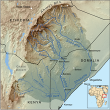
The Shebelle River also known historically as the Nile of Mogadishu, begins in the highlands of Ethiopia, and then flows southeast into Somalia towards Mogadishu. Near Mogadishu, it turns sharply southwest, where it follows the coast. Below Mogadishu, the river becomes seasonal. During most years, the river dries up near the mouth of the Jubba River, while in seasons of heavy rainfall, the river actually reaches the Jubba and thus the ocean.
The Birbir River of southwestern Ethiopia is a tributary of the Baro River, which it creates at its confluence with the Gebba. It is politically important because its course defines part of the boundary between the Mirab Welega and Illubabor Zones of the Oromia Region. Richard Pankhurst notes that the Birbir is economically important for the discovery in 1904 of deposits of platinum along its course.

The Pibor River is a river in eastern South Sudan, which defines part of South Sudan's border with Ethiopia. From its source near Pibor Post it flows north for about 320 kilometres (200 mi), joining the Baro River to form the Sobat River, which is a tributary of the White Nile.
The Akobo River is a river on the border between South Sudan and Ethiopia. From its source in the Ethiopian Highlands near Mizan Teferi it flows west for 434 kilometres (270 mi) to join the Pibor River. The Pibor flows into the Sobat River, which in turn empties into the White Nile.
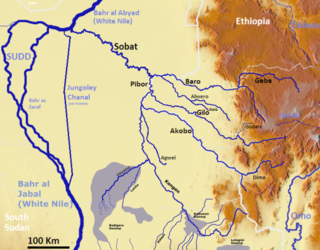
The Gilo River is a river in the Gambela Region of southwestern Ethiopia. A variety of names also knows it: the Gimira of Dizu call it the "Mene", while the Gemira of Chako call it "Owis", and Amhara and Oromo settlers in the early 20th century knew it by a third name, "Bako". From its source in the Ethiopian Highlands near Mizan Teferi it flows to the west, through Lake Tata to join the Pibor River on Ethiopia's border with Sudan. The combined waters then join the Sobat River and the White Nile.

The Ganale Doria River is a perennial river in southeastern Ethiopia. Rising in the mountains east of Aleta Wendo, the Ganale flows south and east to join with the Dawa at the border with Somalia to become the Jubba. The river's tributaries include the Welmel, Weyib, and Mena. The Del Verme Falls is a notable feature of its middle course.
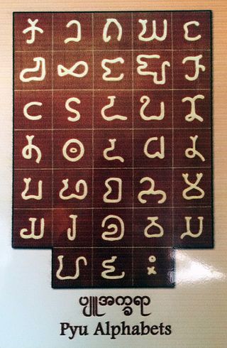
The Pyu language is an extinct Sino-Tibetan language that was mainly spoken in what is now Myanmar in the first millennium CE. It was the vernacular of the Pyu city-states, which thrived between the second century BCE and the ninth century CE. Its usage declined starting in the late ninth century when the Bamar people of Nanzhao began to overtake the Pyu city-states. The language was still in use, at least in royal inscriptions of the Pagan Kingdom if not in popular vernacular, until the late twelfth century. It became extinct in the thirteenth century, completing the rise of the Burmese language, the language of the Pagan Kingdom, in Upper Burma, the former Pyu realm.
The Dembi is a river of southwestern Ethiopia, in the Debub Bench district.
The Erer is a perennial river of eastern Ethiopia. It rises near the city of Harar, in Harari Region, and flows in a primarily southern direction to its confluence with the Shabelle.
Fafen River is a river of eastern Ethiopia. Rising to the east of Harar, in Harari Region, it cuts through a series of wide, flat shelves of sedimentary rocks made of sandstone, limestone, and gypsum as it descends in a south-eastern direction towards the Shebelle River. The Fafen only joins the Shebelle river during times of heavy rainfall.
Galetti River is a river in eastern Ethiopia. It is a tributary of the Ramis River, which is in turn a tributary of the 2,714 km long Shebelle River.
Gololcha River is a river of eastern Ethiopia. It flows into the Awash River.
The Jerer is an intermittent stream of eastern Ethiopia. A tributary of the Fafen River, it rises near Jijiga to flow in a south-easterly direction.
The Sor is a river of southwestern Ethiopia. A tributary of the Birbir River on its left side and joins it at latitude and longitude 8°30′48″N35°11′17″E, the Sor rises in Sayo.

Weyib River is a river of eastern Ethiopia. It rises in the Bale Mountains east of Goba in the Oromia Region, flowing east to pass through the Sof Omar Caves, then to the southeast until it joins the Ganale Dorya River in the Somali Region.
The Welmel is a river of eastern Ethiopia. It is a tributary of the Ganale Dorya River, which in turn is a tributary of the Jubba River. The headwaters of the Welmel are in the Bale Mountains of the Ethiopian Highlands, and it flow southeast for 311 km (193 mi) to it's mouth.
Plazi is a Swiss-based international non-profit association supporting and promoting the development of persistent and openly accessible digital bio-taxonomic literature. Plazi is cofounder of the Biodiversity Literature Repository and is maintaining this digital taxonomic literature repository at Zenodo to provide access to FAIR data converted from taxonomic publications using the TreatmentBank service, enhances submitted taxonomic treatments by creating a version in the XML format Taxpub, and educates about the importance of maintaining open access to scientific discourse and data. It is a contributor to the evolving e-taxonomy in the field of Biodiversity Informatics.

Zenodo is a general-purpose open repository developed under the European OpenAIRE program and operated by CERN. It allows researchers to deposit research papers, data sets, research software, reports, and any other research related digital artefacts. For each submission, a persistent digital object identifier (DOI) is minted, which makes the stored items easily citeable.
Lexibank is a linguistics database managed by the Max Planck Institute for Evolutionary Anthropology in Leipzig, Germany. The database consists of over 100 standardized wordlists (datasets) that are independently curated.