Related Research Articles

Mid Suffolk is a local government district in Suffolk, England. Its council was based in Needham Market until late 2017, and are currently sharing offices with the Suffolk County Council at their headquarters in Ipswich. The largest town of Mid Suffolk is Stowmarket. The population of the District taken at the 2011 Census was 96,731.

Alvecote Priory is a ruined Benedictine Priory in Alvecote, Warwickshire, England. The site has been scheduled as an ancient monument. Now very little remains of the priory, most of the walls have been eroded but a fairly high wall remains on one side. The main entrance arch is the most impressive feature, still standing at around 20 feet (6.1 m) high. The attached dovecote also survives, however both the ruined priory and dovecot are on the Heritage at Risk Register due to vandalism and water damage.

Woodbridge Tide Mill in Woodbridge, Suffolk, England is a rare example of a tide mill whose water wheel still turns and is capable of grinding a wholemeal flour.

Stoke-by-Clare is a small village and civil parish in Suffolk located in the valley of the River Stour, about two miles west of Clare.

Edwardstone is a village and civil parish in the Babergh district, in the county of Suffolk, England. The parish contains the hamlets of Mill Green, Priory Green, Round Maple and Sherbourne Street, and Edwardstone Woods, a Site of Special Scientific Interest.
Alnesbourne Priory, also known as Alnesbourn Priory was a small Augustinian monastic house in the English county of Suffolk. It was located near Nacton to the south-east of Ipswich near to the River Orwell and the current route of the A14.
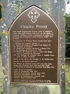
Chipley Priory was a small Augustine religious house, dedicated to the Blessed Virgin, located about 1 mile (2 km) north-west of the village of Poslingford in the English county of Suffolk. The date of its foundation is unknown and the first references to it occur in 1235. The priory never became a major house – a taxation roll from 1291 shows its income at less than £5 per annum – and by 1455 the buildings were ruins. By 1468 the Bishop of Norwich allowed the lands to be annexed by the College at Stoke-next-Clare.
Eye Priory was a Benedictine Priory dedicated to St Peter in the town of Eye in the UK county of Suffolk. It was founded by Robert Malet c. 1080 and originally an Alien Priory dependent on the Abbey of Bernay in Normandy. It became independent in 1385 by charter of Richard II when it could support only 3 -4 monks. It was finally dissolved in 1537 as part of the dissolution of the monasteries with the lands being given to Charles Brandon.
Hoxne Priory was a Benedictine priory at Hoxne in Suffolk, England.

Ixworth Priory was an Augustine priory at Ixworth in the English county of Suffolk. It was founded in the 12th century and dissolved in 1537. The priory was dedicated to St Mary and founded by Gilbert Blundus.
Kersey Priory was a priory in Kersey, Suffolk, England. It was founded in 1218 as a hospital.
Lavenham Priory is a 13th-century Grade I listed building in Lavenham, Suffolk, England.
Rumburgh Priory was a Benedictine priory in located in the village of Rumburgh in the English county of Suffolk. The priory was founded in about 1065 as a cell of St Benet's Abbey at Hulme in Norfolk. At the time of the Domesday survey it had 12 monks. The ownership of the priory was transferred to St Mary's Abbey in York towards the end of the 12th century. The priory had chapels at Wissett and Spexhall but was "suppressed" in 1528 by Cardinal Wolsey and used to provide funds for the building of Cardinal College in Ipswich.
Snape Priory was a priory in Suffolk, England. It was founded as a cell of the Benedictine St John's Abbey, Colchester in Essex.
Woodbridge Priory was a small Augustine priory in Woodbridge in the English county of Suffolk. The priory was founded in around 1193 by Ernald Rufus and was dissolved about 1537 during the dissolution of the monasteries. The site was given to the Wingfield family before passing to Thomas Seckford in 1564. The priory operated a satellite house at Alnesbourne on the River Orwell until about 1466.
The village of Withersdale Street is located within the rural parish of Mendham, on the Norfolk/Suffolk border, in the Waveney Valley. The village is predominantly a ribbon development, along the B1123, from Harleston to Halesworth. To the west of the village lies Mendham Priory, whilst to the east, the Red House, a later Georgian red brick building also mentioned by Pevsner, faces towards the new village hall and overlooks the playing field.

Hoxne Rural District was a rural district within the administrative county of East Suffolk between 1894 and 1934. It was created out of the earlier Hoxne rural sanitary district.

St Mary's Church is a medieval church in Thornham Parva, Suffolk, England. Much of the fabric dates from the 12th century, and it is a Grade I listed building. Originally the church served not only Thornham Parva but the neighbouring village of Thornham Magna, which is now a separate parish.
The Abbey of Bruisyard was a house of Minoresses at Bruisyard in Suffolk. It was founded from Campsey Priory on the initiative of Maud of Lancaster, assisted by her son-in-law Lionel of Antwerp, in 1364-1366.
References
- ↑ "Houses of Cluniac monks: Priory of Mendham | British History Online". www.british-history.ac.uk.
- ↑ "Mendham Priory and walled garden - Suffolk Heritage Explorer". heritage.suffolk.gov.uk.
Coordinates: 52°23′17″N1°19′17″E / 52.3881°N 1.3215°E
| This article about a Suffolk building or structure is a stub. You can help Wikipedia by expanding it. |
| This article about a British Christian monastery, abbey, priory or other religious house is a stub. You can help Wikipedia by expanding it. |