Mercers Creek Bay

Last updated
Antigua and Barbuda location map.svg
Red pog.svg
Mercers Creek Bay
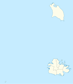
Location of Mercers Creek Bay within Antigua and Barbuda [1]

Mercers Creek Bay (formerly Belfast Bay) is a large bay in the northeast of Antigua. The settlements of Willikies and Seaton's lie close to the bay, which is protected from the Atlantic Ocean by a string of small islands, the largest of which is Crump Island.
Related Research Articles

Arctic Archipelago Group of islands in the Arctic Ocean, off the coast of northern Canada

The Arctic Archipelago, also known as the Canadian Arctic Archipelago, is an archipelago lying to the north of the Canadian continental mainland, excluding Greenland.

Drumore Township, Lancaster County, Pennsylvania Township in Pennsylvania, United States

Drumore Township is a township in southwestern Lancaster County, Pennsylvania, United States. At the 2010 census the population was 2,560.

Turtle Creek, Pennsylvania Borough in Pennsylvania, United States

Turtle Creek is a borough in Allegheny County, Pennsylvania, 12 miles (19 km) southeast of Pittsburgh. The population was 5,349 at the 2010 census. George Westinghouse constructed a manufacturing plant nearby. Turtle Creek takes its name from a small stream that flows into the Monongahela River. Before white settlers arrived, there was a small village of Native Americans living there from the Turtle Clan of the Iroquois Nation.

Springfield Township, Mercer County, Pennsylvania Township in Pennsylvania, United States

Springfield Township is a second-class township in Mercer County, Pennsylvania, United States. The population was 1,981 at the 2010 census.

Clearwater, South Carolina Census-designated place in South Carolina, United States of America

Clearwater is a census-designated place (CDP) in Aiken County, South Carolina, United States. It lies near North Augusta, South Carolina, and is part of the Augusta, Georgia metropolitan area. Clearwater is located in historic Horse Creek Valley. The population was 4,370 at the 2010 census.

Alberni-Clayoquot Regional District Regional district in British Columbia, Canada

The Alberni–Clayoquot Regional District of British Columbia is located on west central Vancouver Island. Adjacent regional districts it shares borders with are the Strathcona and Comox Valley Regional Districts to the north, and the Nanaimo and Cowichan Valley Regional Districts to the east. The regional district offices are located in Port Alberni.

Barnegat Bay

Barnegat Bay is a small brackish arm of the Atlantic Ocean, approximately 42 miles (68 km) long, along the coast of Ocean County, New Jersey in the United States. It is separated from the Atlantic by the long Barnegat Peninsula, as well as by the north end of Long Beach Island, popular segments of the Jersey Shore. The bay is fed by several small rivers, including the Toms River, the Forked River, the Metedeconk River, Cedar Creek, Oyster Creek, Mill Creek, the Westecunk Creek and the Tuckerton Creek which empty into the bay through small estuaries along its inner shore. The communities of Toms River, Silverton, and Forked River sit along the river estuaries on the bay.

Liard River

The Liard River of the North American boreal forest flows through Yukon, British Columbia and the Northwest Territories, Canada. Rising in the Saint Cyr Range of the Pelly Mountains in southeastern Yukon, it flows 1,115 km (693 mi) southeast through British Columbia, marking the northern end of the Rocky Mountains and then curving northeast back into Yukon and Northwest Territories, draining into the Mackenzie River at Fort Simpson, Northwest Territories. The river drains approximately 277,100 km2 (107,000 sq mi) of boreal forest and muskeg.

Saint George Parish, Antigua and Barbuda Parish in Antigua and Barbuda

Saint George is a civil parish of Antigua and Barbuda, located on the island of Antigua. It had a population of 8,055 in 2011.

Saint Peter Parish, Antigua and Barbuda Parish in Antigua and Barbuda

Saint Peter is a civil parish of Antigua and Barbuda, located on northeastern Antigua island. It had a population of 5,325 in 2011.

Huevos (island) Island in Trinidad and Tobago

Huevos is an island in the Republic of Trinidad and Tobago. The island is 1.01 km2 in area. It is one of the "Bocas Islands", which lie in the Bocas del Dragón between Trinidad and Venezuela.

Hawaii Tropical Botanical Garden

The Hawaii Tropical Bioreserve and Garden is a nonprofit botanical garden and nature preserve located on the 4 mile scenic route off of Route 19 at 27-717 Old Māmalahoa Highway, Pāpa'ikou, Hawaii (island), Hawaii. It is open daily except Thanksgiving, Christmas, and New Year's Day. An admission fee is charged to the general public.

Cordelia Slough is a 10.8-mile-long (17.4 km) tidal watercourse which discharges to the Suisun Slough, which in turn empties into Grizzly Bay in Solano County, California. The Suisun Slough, fed by the Green Valley Creek and Red Top Creek, provides a productive habitat for a diversity of aquatic flora and fauna. In particular steelhead migrate up Cordelia Slough to spawn in its two tributaries.

Victoria Harbour (British Columbia) Port in Canada

Victoria Harbour is a harbour, seaport, and seaplane airport in the Canadian city of Victoria, British Columbia. It serves as a cruise ship and ferry destination for tourists and visitors to the city and Vancouver Island. It is both a port of entry and an airport of entry for general aviation. Historically it was a shipbuilding and commercial fishing centre. While the Inner Harbour is fully within the City of Victoria, separating the city's downtown on its east side from the Victoria West neighbourhood, the Upper Harbour serves as the boundary between the City of Victoria and the district municipality of Esquimalt. The inner reaches are also bordered by the district of Saanich and the town of View Royal. Victoria is a federal "public harbour" as defined by Transport Canada. Several port facilities in the harbour are overseen and developed by the Greater Victoria Harbour Authority, however the harbour master's position is with Transport Canada.

Five Island Harbour

Five Island Harbour is a large bay on the west coast of the island of Antigua, in Antigua and Barbuda.

The Kugaryuak River is located in the Canadian Arctic territory of Nunavut in the southwest Kitikmeot Region. It forks into two entities, the Western Kugaryuak and the Eastern Kugaryuak and flows into Coronation Gulf.

Fitches Creek is an affluent coastal neighbourhood in Antigua and Barbuda. It is located on the island of Antigua. Named for the English surname Fitch who may have originally owned the surrounding land. The surrounding area is now a neighborhood in the parish of St George's.

Borders of the oceans Limits of Earths oceanic waters

The borders of the oceans are the limits of Earth's oceanic waters. The definition and number of oceans can vary depending on the adopted criteria. The principal divisions of the five oceans are the Pacific Ocean, Atlantic Ocean, Indian Ocean, Southern (Antarctic) Ocean, and Arctic Ocean. Smaller regions of the oceans are called seas, gulfs, bays, straits, and other terms. Geologically, an ocean is an area of oceanic crust covered by water.

Jenny Buttress is a rock buttress 2.5 nautical miles (5 km) north of Melville Peak, overlooking Destruction Bay on the east side of King George Island, in the South Shetland Islands. It was named by the UK Antarctic Place-Names Committee in 1960 for the alleged sailing vessel Jenny from the Isle of Wight which was found drifting in Drake Passage by the whaler Hope in September 1840. All her crew were dead and the log was entered up to January 17, 1823.

References

  1. "NGA GEOnet Names Server". National Geospatial-Intelligence Agency. 2008-07-07. Archived from the original on 2003-10-08. Retrieved 2008-07-22.

Coordinates: 17°06′N61°43′W / 17.100°N 61.717°W / 17.100; -61.717