
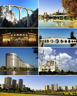
Adana is a large city in southern Turkey. The city is situated on the Seyhan River, 35 km (22 mi) inland from the northeastern shores of the Mediterranean Sea. It is the administrative seat of the Adana province, and has a population of 1.8 million, making it the largest city in the Mediterrenean Region of Turkey.
Adana Province is a province and metropolitan municipality of Turkey located in central Cilicia. The administrative seat of the province is the city of Adana, home to 78.25% of the residents of the province. Its area is 13,844 km2, and its population is 2,274,106 (2022). It is also closely associated with other Cilician provinces of Mersin, Osmaniye, and (northern) Hatay.

Seyhan is a district-municipality in the Adana Province of Turkey. Its area is 444 km2, and its population is 795,012 (2022). It forms the core of the Adana urban area. Seyhan is home to 35 percent of the residents of Adana Province and almost half of the residents of the city of Adana. It is the fifth most populous metropolitan district in Turkey.

Şişli is a municipality and district of Istanbul Province, Turkey. Its area is 10 km2, and its population is 276,528 (2022). Located on the European side of the city, it is bordered by Beşiktaş to the east, Sarıyer to the north, Eyüp and Kağıthane to the west, and Beyoğlu to the south. It is also the name of a specific area of Şişli district centered on the Sişli Mosque.

Taşköprü, historically known as Ponte Sarus, is a Roman bridge spanning the Seyhan River in Adana that was probably built in the first half of the second century AD. The bridge was a key link in ancient trade routes from the Mediterranean Sea to Anatolia and Persia. Until its closure in 2007, it was one of the oldest bridges in the world open to motorized vehicles. Since 2007 it has only carried foot traffic, and now hosts social and cultural events.

Çukurova or the Cilician Plain, is a large fertile plain in the Cilicia region of southern Turkey. The plain covers the easternmost areas of Mersin Province, southern and central Adana Province, western Osmaniye Province and northwestern Hatay Province.

Yüreğir is a municipality and district of Adana Province, Turkey. Its area is 835 km2, and its population is 404,726 (2022). It is the second most populated district of the province with a population of over 400,000, mostly concentrated on the east side of the Seyhan river, within the city of Adana.

Sabancı Merkez Camii in Adana is the second largest mosque in Turkey. The exterior of the mosque is similar to the Selimiye Mosque in Edirne, though it has six minarets, similar to the Sultan Ahmed Mosque in Istanbul.
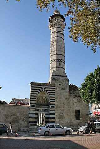
The Great Mosque of Adana, also known as the Ramazanoglu Mosque, is a mosque from the 16th century in Adana, Turkey. It forms part of a complex (külliye) that includes a madrasah and a mausoleum (türbe). The complex is on Kızılay Street, next to the Ramazanoğlu Hall.
Aytaç Durak is a Turkish politician, and was the mayor of Adana between 1984 and 2014, excluding one term (1989–1994). He is the longest serving locally elected city mayor in Turkey. Adding his 17 years as a municipal councillor, he served the municipality of Adana for 42 years by the end of this term in 2014. He was the president of the Municipalities Union of Turkey for 17 years and the Çukurova Municipalities Union for 12 years.

Tepebağ is a neighbourhood (mahalle) in the municipality and district of Seyhan, Adana Province, Turkey. Its population is 903 (2022). It is a historical neighborhood in the old town of Adana. It is situated on a hill overlooking the Seyhan River on the west, steps away from the Taşköprü, and reflects the traditional housing architecture of the city. Tumulus at Tepebağ is the area of the first settlements in Adana.

Adana Metro is a rail rapid transit system extending 13.5 kilometers (8.39 mi) along a north–south corridor through Adana, with 13 stations. It can transport 21,600 passengers per hour per direction. The total travel time on the metro, end to end, takes 21 minutes, including all stops.

Adana Center for Arts and Culture is a public facility for cultural events, operating at the historical state building of Adana that served as a school for most of its history. The center is located on the west bank of Seyhan River just south of the Taşköprü, on Seyhan Street.

Adana Archaeology Museum is a museum in Adana that houses the historical heritage of Cilicia. The museum is currently located at the former Simyonoglu textile plant that was built in 1906 by Aristidi Simyonoglu as being the largest manufacturing plant of the region. It is one of the oldest archaeological museums in Turkey.

Adana station is a railway station in Adana and one of the major railway hubs in Turkey. The station is located at the İstasyon Square, in Kurtuluş, Seyhan.
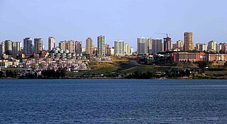
Çukurova is a municipality and district of Adana Province, Turkey. Its area is 250 km2, and its population is 389,175 (2022). Its population is concentrated within the city of Adana, occupying north-west of the city. It is a modern residential district which came into being in the last 30 years as the city expanded north. Çukurova is located north of the Seyhan district, west of the Seyhan River and south of the Seyhan Reservoir.
Adana Half Marathon is an IAAF international athletic event that takes place in Adana annually since 2011. The marathon is organized the first Sunday following January 5, the independence day of Adana. Master Men, Master Women and Wheelchair competitions, as well as 4 km Public Run are held during the event.

Emirgan is a neighbourhood in the municipality and district of Sarıyer, Istanbul Province, Turkey. Its population is 8,290 (2022). It is a leafy, middle-class suburb of Istanbul, on the western shore of the Bosphorus north of the Fatih Sultan Mehmet Bridge.
Lower Seyhan Irrıgation Project is one of the major irrigation projects of Turkey, which is located in the Seyhan River basin.

Site Mosque is a mosque located in Ilkadim district of Samsun. The mosque is a prominent architectural landmark in the city center due to both its location and unique architectural style. It was built between 1976 and 1985 as part of a redevelopment of the city center. Plans were announced in 2022 to demolish the mosque as part of an urban renewal campaign of Samsun's City Center.


