
Merrill Township is a civil township of Newaygo County in the U.S. state of Michigan. The population was 590 at the 2000 census.
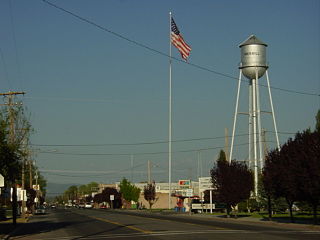
Merrill is a city in Klamath County, Oregon, United States. The population was 844 at the 2010 census.

The Snoqualmie River is a 45-mile (72 km) long river in King County and Snohomish County in the U.S. state of Washington. The river's three main tributaries are the North, Middle, and South Forks, which drain the west side of the Cascade Mountains near the town of North Bend and join near the town of Snoqualmie just above the Snoqualmie Falls. After the falls the river flows north through rich farmland and the towns of Fall City, Carnation, and Duvall before meeting the Skykomish River to form the Snohomish River near Monroe. The Snohomish River empties into Puget Sound at Everett. Other tributaries of the Snoqualmie River include the Taylor River and the Pratt River, both of which enter the Middle Fork, the Tolt River, which joins at Carnation, and the Raging River at Fall City.

The Genesee River is a tributary of Lake Ontario flowing northward through the Twin Tiers of Pennsylvania and New York in the United States.
Bitely is an unincorporated community within Newaygo County in the U.S. state of Michigan. It also extends into Lake County as well. It is within Lilley Township about one mile west of M-37 in the Manistee National Forest. It is near Bitely Lake, Lamoreaux Lake, Isaac Lake, Houseman Lake and several smaller lakes.

Lost River begins and ends in a closed basin in northern California and southern Oregon in the United States. The river, 60 miles (97 km) long, flows in an arc from Clear Lake Reservoir in Modoc County, California, through Klamath County, Oregon, to Tule Lake in Siskiyou County, California. About 46 mi (74 km) of Lost River are in Oregon, and 14 miles (23 km) are in California.

Mount St. Helens National Volcanic Monument is a U.S. National Monument that includes the area around Mount St. Helens in Washington. It was established on August 27, 1982 by U.S. President Ronald Reagan following the 1980 eruption. The 110,000 acre (445 km2) National Volcanic Monument was set aside for research, recreation, and education. Inside the Monument, the environment is left to respond naturally to the disturbance.
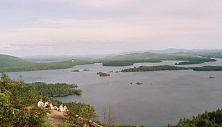
Squam Lake is a lake located in the Lakes Region of central New Hampshire, United States, south of the White Mountains, straddling the borders of Grafton, Carroll, and Belknap counties. The largest town center on the lake is Holderness. The lake is located northwest of much larger Lake Winnipesaukee.

Manson is an unincorporated community and census-designated place in Chelan County in the U.S. state of Washington. It was named in 1912 for Manson F. Backus, president of the Lake Chelan Land Company. Manson is located in the north-central portion of the state on the north shore of Lake Chelan, approximately 7 miles (11 km) northwest of the city of Chelan.

The Ontonagon River is a river flowing into Lake Superior at the village of Ontonagon, on the western Upper Peninsula of Michigan in the United States. The main stem of the river is 25 miles (40 km) long and is formed by a confluence of several longer branches, portions of which have been collectively designated as a National Wild and Scenic River. Several waterfalls occur on the river including Agate Falls and Bond Falls.

Carr Township is one of twelve townships in Clark County, Indiana. As of the 2010 census, its population was 3,452 and it contained 1,378 housing units.

Leavitt is an unincorporated community in Lassen County, California, United States. It is located alongside the Southern Pacific Railroad 7 miles (11 km) east of Susanville, and 7 miles west of Litchfield, at an elevation of 4,104 feet (1,251 m).

The Pratt River is a river in King County in Washington. It is a tributary of the Middle Fork Snoqualmie River. It was named for prospector George A Pratt, who discovered nearby iron deposits in 1887.
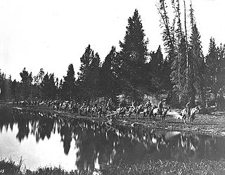
The Hayden Geological Survey of 1871 explored the region of northwestern Wyoming that later became Yellowstone National Park in 1872. It was led by geologist Ferdinand Vandeveer Hayden. The 1871 survey was not Hayden's first, but it was the first federally funded, geological survey to explore and further document features in the region soon to become Yellowstone National Park and played a prominent role in convincing the U.S. Congress to pass the legislation creating the park. In 1894, Nathaniel P. Langford, the first park superintendent and a member of the Washburn-Langford-Doane Expedition which explored the park in 1870, wrote this about the Hayden expedition:
We trace the creation of the park from the Folsom-Cook expedition of 1869 to the Washburn expedition of 1870, and thence to the Hayden expedition of 1871, Not to one of these expeditions more than to another do we owe the legislation which set apart this "pleasuring-ground for the benefit and enjoyment of the people"

Merrills Landing is an unincorporated community in Butte County, California, on the Sacramento River. It lies at an elevation of 177 feet.
Belfast is an unincorporated community in Lassen County, California. It is located 5.5 miles (8.9 km) northwest of Litchfield, at an elevation of 4134 feet.
Merrill, legally Merrill Lynch, Pierce, Fenner & Smith Incorporated and previously branded as Merrill Lynch, is an American investing and wealth management division of Bank of America. Along with BofA Securities, the investment banking arm, both firms engage in prime brokerage and broker-dealer activities. The firm is headquartered in New York City, and once occupied the entire 34 stories of 250 Vesey Street, part of the Brookfield Place complex in Manhattan. Merrill employs over 14,000 financial advisors and manages $2.3 trillion in client assets. The company also operates Merrill Edge, an electronic trading platform.

Conrad is an unincorporated community in Lake Township, Newton County, in the U.S. state of Indiana.

Lake Bellevue, also called Lake Sturtevant, is a small lake inside the city limits of Bellevue, Washington. Along with Phantom Lake and Larsen Lake, it is one of three small lakes inside the city, which also borders Lake Washington and Lake Sammamish. Sturtevant Creek, a tributary of Kelsey Creek, has its origin at Lake Bellevue and contains Chinook, Sockeye and Coho salmon. In the 773-acre (313 ha) creek basin, 71% of the land has an impervious surface.
