Related Research Articles

The Kenya African National Union (KANU) is a Kenyan political party that ruled for nearly 40 years after Kenya's independence from British colonial rule in 1963 until its electoral loss in 2002. It was known as Kenya African Union (KAU) from 1944 but due to pressure from the colonial government, KAU changed its name to Kenya African Study Union (KASU) mainly because all political parties were banned in 1939 following the start of the Second World War. In 1946 KASU rebranded itself into KAU following the resignation of Harry Thuku as president due to internal differences between the moderates who wanted peaceful negotiations and the militants who wanted to use force, the latter forming the Aanake a forty, which later became the Mau Mau. His post was then occupied by James Gichuru, who stepped down for Jomo Kenyatta in 1947 as president of KAU. The KAU was banned by the colonial government from 1952 to 1960. It was re-established by James Gichuru in 1960 and renamed KANU on 14 May 1960 after a merger with Tom Mboya's Kenya Independence Movement.
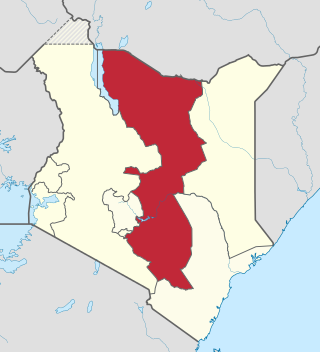
The Eastern Province of Kenya was one of 8 Provinces of Kenya. Its northern boundary ran along with that of Ethiopia; the North Eastern Province and Coast Province lay to the east and south; and the remainder of Kenya's provinces, including Central Province, ran along its western border. The provincial capital was Embu.
Embu is a town located approximately 125 kilometres (78 mi) northeast of Nairobi towards Mount Kenya. Embu served as the provincial capital of the former Eastern Province and currently serves as the headquarters of Embu County in Kenya. Located on the south-eastern foothills of Mount Kenya, the Municipality of Embu had a population of 204,979 in 2019 census. Embu is also the 8th Largest Municipality in Kenya. It is the commercial hub of the Central Eastern part of Kenya and provides an avenue for trade, tourism and highway transit between the national capital and the Northern Frontier.
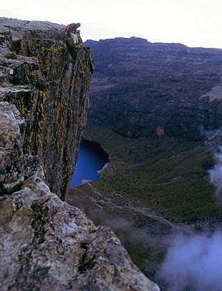
Meru County is one of the 47 counties of Kenya located in the former Eastern Province. It borders Isiolo County to the north, Tharaka-Nithi County to the South, Nyeri County to the southwest and Laikipia County to the west. Meru County has a population of 1.35 million people. It is home to the Meru people.
Kitui is a town and capital of Kitui County in Kenya, 185 kilometres east of Nairobi and 105 kilometres east of Machakos. it covers an area approximately 30,496.4 km squares and lies between latitudes 0°10 South and 3°0 South and longitudes 37°50 East and 39°0 East. It borders seven counties i.e. Machakos and Makueni counties to the west, Tana River County to the east and south-east, Taita Taveta County to the south, Embu to the north-west, and Tharaka-Nithi and Meru counties to the north. Kitui became the headquarters of Kitui County after the adoption of the new constitution and the devolved government.

The Meru or Amîîrú are a Bantu ethnic group that inhabit the Meru region of Kenya. The region is situated on the fertile lands of the north and eastern slopes of Mount Kenya in the former Eastern Province.
Meru is a Bantu language spoken by the Meru people (Ameru) who live on the Eastern and Northern slopes of Mount Kenya and on the Nyambene ranges. They settled in this area after centuries of migration from the north.
Murang'a District was one of the districts of Kenya's Central Province. Its capital town was also now named Murang'a. It is inhabited mainly by and is considered the home of the Kikuyu, the largest community in Kenya.
Meru North District was an unconstitutionally created district of Kenya, located in that country's Eastern Province. In 1992, it was split from Meru District, along with Meru Central District, Meru South District (Nithi), and Tharaka District. Since the High Court's decision in September 2009, the territory of Meru North has been part of Meru County.
Meru South District, also known as Nithi District, was an unconstitutionally created district of Kenya, located in the country's Eastern Province. In 1992, it was split from the large Meru District, along with Meru Central District, Meru North District, and Tharaka District. In September 2009, the Supreme Court ruled that its creation was unconstitutional, and that it belonged in Tharaka-Nithi District.
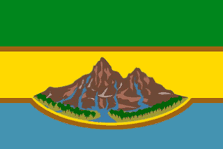
Tharaka-Nithi County is one of the 47 counties of Kenya. It was created from Kenya's Eastern Province. The county has an area of 2609 km2 and as of the 2019 census a population of 393,177.

Chogoria is a town located in Mwimbi Division of Tharaka-Nithi County of Kenya. It is located roughly 97 miles from Nairobi. It is connected to the rest of the country by an all-weather, tarmacked road, the Meru-Nairobi highway. The closest town to Chogoria is Chuka. Other surrounding towns are Igoji, Nkubu, Meru and Embu. The town has an urban population of 28,415 and a rural population of 3,208.
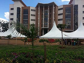
Chuka is a town on the eastern slopes of Mount Kenya, in Kenya about 65 km south Of Meru Town. It falls within Tharaka-Nithi County and the former Eastern Province. Between 1992 and 2009, Chuka was the capital of Tharaka-Nithi District. Tharaka Nithi District was further split into Meru South and Tharaka Districts with Chuka remaining the Capital of Meru South. Later, Meru South and Tharaka were amalgamated into Tharaka-Nithi County.

The Counties of Kenya are geographical units created by the 2010 Constitution of Kenya as the new units of devolved government. They replaced the previous provincial system. The establishment and executive powers of the counties is provided in Chapter Eleven of the Constitution on devolved government, the Constitution's Fourth Schedule and any other legislation passed by the Senate of Kenya concerning counties. The counties are also single-member constituencies which elect members of the Senate, and special woman members to the National Assembly.

The Mbeere or Ambeere people are a Bantu ethnic group inhabiting the former Mbeere District in the now-defunct Eastern Province of Kenya. According to the 2019 Kenya National census, there are 195,250 Mbeere who inhabit an area of 2,093 km2. They speak Kīmbeere language, a dialect of Embu, which is very similar to the languages spoken by their neighbours, the Kamba, Embu and Kikuyu.

Sub-counties, formerly known as Districts, are the decentralised units through which government of Kenya provides functions and services. At national level, sub-counties take a more administrative function like security, statistical purposes, provision of government services, etc. Even though the sub-counties are divisions of counties, powers to create new national sub-counties lies with the national government. As of 2023, there are 314 sub-counties, compared to 290 constituencies. A deputy county commissioner is appointed by the state to lead each sub-county. The sub-counties are further divided into divisions, locations and sub-locations.
Tharaka-Nithi District was one of the districts of Kenya located in that country's Eastern Province from 1992 to 1998. Its former boundaries now corresponds to those of Tharaka-Nithi County.

Abraham Kithure Kindiki is a Kenyan politician and lawyer who has been the 13th and current Deputy President of the Republic of Kenya since 1 November 2024. He previously served as the Cabinet Secretary for Interior and National Administration from 2022 to 2024 and as the Senator for Tharaka-Nithi County from 2013 to 2022.
Central Nyanza was an administrative district of Nyanza Province in western Kenya. It was headquartered in Kisumu. Created as Kisumu District in 1902, after the eastern region of Uganda was transferred to the East Africa Protectorate. At the time the district was under Kisumu Province, later renamed Nyanza Province in 1909. There were boundary alterations between 1920 and 1921, leading to the district being renamed Central Kavirondo. In 1948, Central Kavirondo was renamed Central Nyanza.
South Nyanza was an administrative district of Nyanza Province in western Kenya. It was headquartered in Kisumu. Following territorial transfer from Uganda to the East Africa Protectorate, Kisii District was administered as one unit with Ugaya District both headquartered in Karungu. Kisii was founded in 1907 and quickly rose to be the districts, Kisii and Ugaya, headquarters. At the time the districts were under Kisumu Province, later renamed Nyanza Province in 1909. They were later consolidated and referred to as South Kavirondo. In 1948, South Kavirondo was renamed South Nyanza. In 1962, Kisii District was carved out of South Nyanza. The smaller South Nyanza was then headquartered at Homa Bay.
References
- ↑ "description of the districts and provinces". Syracuse University. p. 6. Retrieved 16 August 2024.
- ↑ Mueller, Susanne D. (1984). "Government and Opposition in Kenya, 1966-9". The Journal of Modern African Studies. 22 (3): 399–427. ISSN 0022-278X.
- ↑ "Constitutions of Kenya - Senate under the Old Constitution". ustawi.info.ke. Retrieved 2024-08-16.
- ↑ "Constitutions of Kenya - 46 Districts of 1993". www.ustawi.info.ke. Retrieved 2024-08-16.