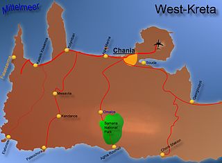
The Samariá Gorge is a National Park of Greece since 1962 on the island of Crete – a major tourist attraction of the island – and a World's Biosphere Reserve.

Neilton is an unincorporated community and census-designated place (CDP) in Grays Harbor County, Washington, United States. The population was 315 at the 2010 census.

Maleme is a small village and military airport 16 km (9.9 mi) to the west of Chania, in north western Crete, Greece. It is located in Platanias municipality, in Chania regional unit.
Argastiri is a small village in Chania regional unit on the island of Crete, Greece. It has 19 residents, its elevation is 650 meters above sea level and it lies 48 km south of Chania. It is within the municipality of Kantanos-Selino. A battle took place in Argastiri during the Greek War of Independence against the Turks. 450 Greeks under Nikiforos Hatzidakis lost the battle by 2000 Turks under Kaouris, the aga of Kantanos. Nikiforos Hatzidakis was killed.

Togo is a village in the Canadian province of Saskatchewan within the Rural Municipality of Cote No. 271 and Census Division No. 9. It is 800 metres west of the Manitoba border and approximately 72 km (45 mi) northeast of the City of Yorkton.
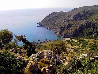
Lissus or Lissos was a town on the south coast of ancient Crete, which the anonymous Stadiasmus Maris Magni places between Syia and Calamyde. The Peutinger Table gives 16 M.P. as the distance between Cantanum and Lissus. It was one of the harbours of Elyrus. It was established in the Classical period and flourished until the Late Antiquity. Its name was made certain by inscriptions. The early history of the city is unknown. Based on inscriptions and coins of the 3rd century BCE, we know the city allied with King Magas of Cyrene, and joined the League of Oreians. The koinon of the Oreians consisted of the cities Lissus, Syia, Poikilassos, Tarrha, Yrtakina and Elyrus. Lissus had powerful trading and fishing fleets.

Souda Bay is a bay and natural harbour near the town of Souda on the northwest coast of the Greek island of Crete. The bay is about 15 km long and only two to four km wide, and a deep natural harbour. It is formed between the Akrotiri peninsula and Cape Drapano, and runs west to east. The bay is overlooked on both sides by hills, with a relatively low and narrow isthmus in the west near Chania.
Alikianos is the head village of the Mousouroi municipal unit in Chania regional unit, Crete located approximately 12.5 kilometers southwest of Chania. Alikianos is best known outside the island for the fierce fighting which took place there during the 1941 Battle of Crete, during which the 8th Greek Regiment (Provisional) aided by the local population, helped cover the retreat of the 10th New Zealand Division, to which it was attached. In retribution, the German paratroopers executed many civilians from Alikianos and the nearby villages.
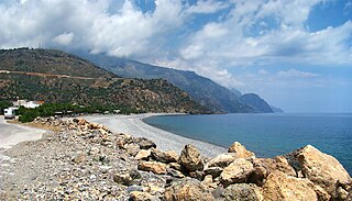
Sougia is a community and a small village in Chania regional unit on the island of Crete, Greece. It is part of the municipal unit of East Selino. It is located on the south coast of the island, 70 km south of Chania. The community consists of the following villages :

Agia Eirini Gorge, sometimes called St. Irene Gorge, is located in the south-west of the island of Crete, Greece, in Lefka Ori. The gorge starts near the village of Agia Eirini and it ends near the village of Sougia, on the south coast. It is 7.5 kilometres (4.7 mi) long and 45–500 metres (148–1,640 ft) deep, in a forested area with steep mountain cliffs. In 1866, 1,000 women and children escaped from the Ottomans through this gorge.

Kampanos is a community and a village in Chania regional unit on the island of Crete, Greece. It is the seat of the municipal unit of East Selino. The community consists of the following villages :
Koxari is a village near Iraklion (Heraklion) in Crete. It is in the Municipality of Gouves. The village is at an altitude of 180 meters and is 23.3 km from Heraklion.
Zympragos is a village in Chania regional unit of the island of Crete, Greece. It was part of the former Kissamos Province and belongs to the municipality of Platanias. It has 39 residents.
Stalos is a town on the island of Crete in Greece. It had a population of 868 (2011) and since the local government reform it is part of the municipality Chania. It is 8 km west from the city of Chania and the nearby beach at Kato Stalos is a popular resort in summer that forms a continuous strip with nearby Agia Marina and Platanias.
Malaxa is a village in the Chania regional unit on Crete in Greece. The 2011 census counted a population of 115 people in the village. In ancient times the Malaxa area was under the sphere of influence of the nearby powerful city of Kydonia. Malaxa lies on the feet of the Lefka Ori, and is separated from the large city of Chania by the Chania Plain.

Koszarawa is a village in Żywiec County, Silesian Voivodeship, in southern Poland, close to the border with Slovakia. It is the seat of the gmina called Gmina Koszarawa. It lies in historic Lesser Poland, approximately 15 kilometres (9 mi) east of Żywiec, and 73 km (45 mi) south-east of the regional capital, Katowice.
Sidi Bou Ali is a town and commune in the Sousse Governorate, Tunisia. As of 2004 it had a population of 9,011.
Pälli is a village in Lääne-Nigula Parish, Lääne County, in western Estonia.
Nipos or Nippos is a village in Chania regional unit and is 33 km away from the city of Chania. It is part of the municipality of Apokoronas.

Akrotiri is a village on the island of Santorini in Greece. It is located 15 kilometers south of the capital Fira, built on the slopes of a hill offering staggering views of the caldera cliffs. On top of this hill, there are remains of a Venetian castle (Goulas). Akrotiri is part of the Thira region and had 489 permanent inhabitants according to the Greek census of 2011.