
Mesurado River is a river of Liberia. It flows through the capital of Monrovia and is crossed by the People's Bridge, built in the 1970s. [1]
Mesurado River is a river of Liberia. It flows through the capital of Monrovia and is crossed by the People's Bridge, built in the 1970s. [1]
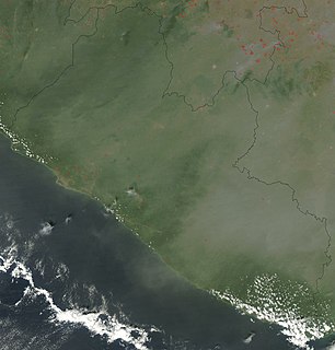
Liberia is a sub-Saharan nation in West Africa located at 6 °N, 9 °W. It borders the north Atlantic Ocean to the southwest and three other African nations on the other three sides, Sierra Leone to the northwest, Guinea to the northeast and Ivory Coast to the east.

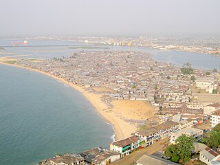
Monrovia is the capital city of the West African country of Liberia. Founded in 1822, it is located on Cape Mesurado on the Atlantic coast, and is the country's most populous city. As of the 2008 census, with 1,010,970 residents, it was home to 29% of Liberia’s total population. Monrovia is also the country’s economic, financial and cultural center. Its economy is primarily centered on its harbor and its role as the seat of Liberia's government.

Montserrado County is a county in the northwestern portion of the West African nation of Liberia containing its national capital, Monrovia. One of 15 counties that comprise the first-level of administrative division in the nation, it has 17 sub political districts. As of the 2008 Census, it had a population of 1,118,241, making it the most populous county in Liberia. The area of the county measures 1,912.7 square kilometres (738.5 sq mi), the smallest in the country. Bensonville serves as the capital.

The Pepper Coast or Grain Coast was a coastal area of western Africa, between Cape Mesurado and Cape Palmas. It encloses the present republic of Liberia. The name was given by European traders.

Bomi is a county in the northwestern portion of the West African nation of Liberia. The county was established in 1984. The county's area is 746 square miles (1,900 km2).

Klay District is one of four administrative districts of Bomi County, Liberia. As of 2008 the population was 22,355.
Seuhn Mecca District is one of four administrative districts of Bomi County, Liberia.
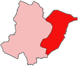
Greater Monrovia is one of four districts located in Montserrado County, Liberia. It contains the country's capital Monrovia. It recorded a population of 970,824 in the 2008 census.

The Saint Paul River is a river of western Africa. Its headwaters are in southeastern Guinea. Its upper portion in Guinea is known as the Diani River or Niandi River, and forms part of the boundary between Guinea and Liberia. It is known locally as the Du by the Gola people in Liberia.

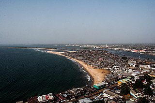
Cape Mesurado, also called Cape Montserrado, is a headland on the coast of Liberia near the capital Monrovia and the mouth of the Saint Paul River. It was named Cape Mesurado by Portuguese sailors in the 1560s. It is the promontory on which African American settlers established the city now called Monrovia on 25 April 1822.
The National Museum of Liberia is a national museum in Monrovia, Liberia. Initially housed in the First Executive Mansion on Ashmun Street of the city which is now used as a library, it was established by an Act of the National Legislature in 1958 under the administration of Liberia's 18th President, Dr William V.S. Tubman. Partly funded by UNESCO, in coordination with the Department of Public instructions, its primary goal was to obtain, preserve and display cultural artefacts and other historical items which depict the country's heritage.
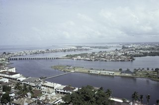
The Gabriel Tucker Bridge formerly the People's Bridge, is a bridge over the Mesurado River in Monrovia, Liberia. It was built between 1972 and 1976. The construction caused some minor disruption to local settlements and the Liberian National Museum had to be relocated in the mid-1970s to make room for its construction. It was designed by Gabriel Johnson Tucker, and the bridge was named in his honor by Liberian President William R. Tolbert.
Bushrod Island is an island near Monrovia, Liberia surrounded by the Atlantic Ocean, the Saint Paul River, the Mesurado River and Stockton Creek. It contains the Freeport of Monrovia, the major national port of Liberia and a variety of businesses. It also contains numerous residential areas and government buildings. There are four towns on the island, Vai Town, New Kru Town, Logan Town and Clara Town.
West Point is a township of the Liberian capital city of Monrovia, located on a 0.53 km2 peninsula which juts out into the Atlantic Ocean between the Mesurado and Saint Paul rivers. West Point is one of Monrovia's most densely populated slums.

New Georgia is a township in Montserrado County, Liberia that was first settled by Africans who had been taken from slave ships seized or wrecked near the United States and then sent to Liberia after several years had passed.
The Liberia Cement Corporation, also known as Cemenco, is a major company in the economy of the Republic of Liberia. One of the oldest firms operating in the country in the early twenty-first century, it holds a monopoly on the sale of cement in the country. The firm's original factory was opened by Mr. Fouad R Khalifa a Lebanese businessman and by President William V.S. Tubman in early January 1968.. In the early 2010s, another firm announced its goal of entering the Liberian market, but by late 2012, no other companies were yet in the market. In response to this challenge, corporate officials announced in November 2012 their plans to erect a new manufacturing plant. Its previously existing facility is located on Bushrod Island in Monrovia, as is the site of the plant announced in November 2012; at that time, company bosses were planning to use a site formerly occupied by a manufacturing component of the defunct Mesurado Group of Companies. Historically, Cemenco had warehouses at the Freeport of Monrovia, but an ownership dispute over the warehouse property resulted in its conveyance to a Chinese firm in late 2012.
Matilda Newport was an Americo-Liberian colonist and folk hero. She is known for her actions in 1822 when she is alleged to have defended the settlement Cape Mesurado with a cannon she lit from her pipe. She is a controversial figure in light of the tensions between Americo-Liberians and native Liberians. The historical accuracy of the account has been challenged. A national holiday in her honour, Matilda Newport Day, was celebrated annually on 1 December from 1916 until it was abolished in 1980.
The following is a timeline of the history of the city of Monrovia, Liberia.
The Colony of Liberia, later the Commonwealth of Liberia, was a private colony of the American Colonization Society (ACS) beginning in 1822. It became an independent nation—the Republic of Liberia—after declaring independence in 1847.
Providence Island was the site of the first successful settlement of American freedmen by the American Colonization Society in Liberia. It has been proposed as a UNESCO World Heritage Site by the government of Liberia.
Coordinates: 6°19′03″N10°47′53″W / 6.3176°N 10.798°W