Una Vida is an archaeological site located in Chaco Canyon, San Juan County, New Mexico, United States. According to tree rings surrounding the site, its construction began around 800 AD, at the same time as Pueblo Bonito, and it is one of the three earliest Chacoan Ancestral Puebloan great houses. Comprising at least two stories and 160 rooms, it shares an arc or D-shaped design with its contemporaries, Peñasco Blanco and Pueblo Bonito, but has a unique "dog leg" addition made necessary by topography. It is located in one of the canyon's major side drainages, near Gallo Wash, and was massively expanded after 930 AD.

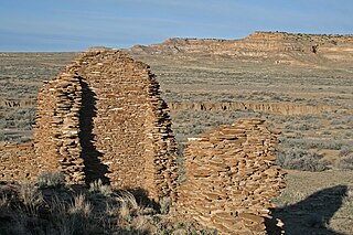
Chetro Ketl is an Ancestral Puebloan great house and archeological site located in Chaco Culture National Historical Park, New Mexico, United States. Construction on Chetro Ketl began c. 990 and was largely complete by 1075, with significant remodeling occurring in the early and mid-1110s. Following the onset of a severe drought, most Chacoans emigrated from the canyon by 1140; by 1250 Chetro Ketl's last inhabitants had vacated the structure.

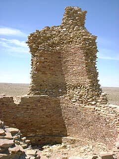
Pueblo del Arroyo is an Ancestral Puebloan great house and archaeological site located in Chaco Culture National Historical Park, in New Mexico, United States.
The Hyde Exploring Expedition, sponsored by brothers Talbot and Fred Hyde Jr., and directed by Dr. George H. Pepper, conducted excavations in Chaco Canyon from 1896 to 1901, when accusations of impropriety levied by Edgar L. Hewett put an end to their archeological surveys. A subsequent investigation by Steven Holsinger of the US General Land Office vindicated the Hydes and their partner, Richard Wetherill.
Kin Ya'a is a Chacoan great house and the center of a significant Ancestral Puebloan outlier community. It is located near Crownpoint, New Mexico on the Dutton Plateau, 25 miles (40 km) south of Chaco Canyon.
Escavada Wash is a tributary of the Chaco Wash, in Chaco Canyon, New Mexico, United States. It flows south and west from its origin near Lybrook, New Mexico, and meets the Chaco Wash at the west end of canyon. Several small Ancestral Puebloan archeological sites border the wash, which is located north of the Chacoan great house Pueblo Alto.
Francisco Hosta was the civil governor of Jemez Pueblo in 1849. He acted as a guide for several archeological expeditions to the Ancestral Puebloan ruins in Chaco Canyon, including the Simpson group in 1849, one led by Dr. Oscar Lowe in 1874, and in 1877 he guided photographer William Henry Jackson, who named Hosta Butte in his honor. He might have also guided José Antonio Vizcarra during his 1823 campaign against the Navajo people, during which Vizcarra re-discovered Chaco Canyon.

A great house is a large, multi-storied Ancestral Puebloan structure; they were built between 850 and 1150. Archeologists differ as to their purpose, but they might have been residences for large numbers of people, or ceremonial centers that only priests occupied. Archeologist Stephen H. Lekson has proposed that they might have been the palaces of Puebloan royalty, particularly those found at Chaco Canyon.
Atlatl Cave is an important archeological site that contains organic evidence of occupation by Archaic North Americans c. 900 BCE. It is located at the west end of Chaco Canyon, New Mexico. During the 1970s, archeologists discovered plant material, a yucca fiber sandal, beads, basketry, and fabric made from rabbit fur in the cave. They also found part of an atlatl, or spear-thrower, from which the site got its name. Atlatl Cave is important because unlike most Archaic sites in the canyon, the shelter protected the organic materials inside, which allowed for accurate radiocarbon dating.
Andrews Outlier is an Ancestral Puebloan archeological site located in the Red Mesa Valley in the southern portion of the San Juan Basin, approximately 50 miles (80 km) south of Chaco Canyon, New Mexico, United States. The site is notable for its three great kivas and thirty small house structures. The area has not been excavated, but the visible architecture indicates that the primary purpose of the buildings was community rituals. Andrews Outlier was occupied from around 900 to 1100 CE. The site is owned by The Archaeological Conservancy and administered by the US Bureau of Land Management.

Bis sa'ani is an Ancestral Puebloan great house and small house community and archeological site. Located in Chaco Canyon, New Mexico, United States, it contains thirty-five rooms and lies near the south of Escavada Wash 8 miles (13 km) from Pueblo Bonito. While outside the canyon, it is not considered an outlier, but included within the core group of ruins. There are several small house sites in the area, but no great kiva. Bis sa'ani was occupied during the early 11th century.
The Cerrillos Turquoise Mines are Ancestral Puebloan turquoise mines located in the Cerrillos Hills, 20 miles (32 km) southwest of Santa Fe, New Mexico. Archeologists believe that most of the turquoise found at Chaco Canyon was mined in the Cerrillos Hills. Many modern Pueblo people claim to have ancient rights to these mines. In 1977, neutron activation analysis linked an artifact from Chetro Ketl to the Cerrillos mines.
The Chaco Meridian is a theoretical north-south axis on which lie the Ancestral Puebloan sites, Aztec Ruins and Chaco Canyon, as well as Paquime at Casas Grandes in northern Mexico. Archeologist Stephen H. Lekson developed the theory, which suggests the location of these sites on the same approximate line of longitude (107°57'25") was intentional, and represents a ceremonial connection between them.
The Chacra Face Road is one of eight Ancestral Puebloan roads that enters Chaco Canyon, New Mexico. It enters the canyon through a break in the Chacra Mesa called the Fajada Gap, and ends at the great house Una Vida. It probably connected Una Vida to an eastern Puebloan community, Guadalupe Outlier.
Dune Dam is a long sand dune that lies at the western end of Chaco Canyon, New Mexico, near the confluence of the Chaco and Escavada Washs. The dune was created by winds that brought sand up the Chaco River. When the dune was large enough, it dammed the Chaco Wash and created a small and shallow lake near the Ancestral Puebloan great house, Penasco Blanco. Archeological evidence suggests that the dune was breached around 900 CE. Chacoans filled the breach with masonry sometime in the early 11th century, and built an accompanying reservoir lined with stones that was visible until 1920. The dam stopped Chaco Wash from further deepening, which helped raise the water table in the canyon, aiding Chacoan farming. The absence of a lacustrine plain behind the dam led geologist Stephen A. Hall to question this interpretation.
East Community is an Ancestral Puebloan great house community and archeological site located 12 miles (19 km) east of Pueblo Bonito, at the eastern end of Chaco Culture National Historical Park, New Mexico. Archeological evidence uncovered during the 1980s suggests the site was occupied by both Chacoans and Mesa Verdeans. Eighty-two structures have been identified in the area, including a great house that contains twenty-five rooms and several small house sites. At least one kiva has been uncovered there, but no great kivas. A partial road segment is visible there, but archeologists are unsure of it connects with a longer segment thought to originate near Pueblo Pintado. The great house at East Community was constructed in the 10th century, with significant additions completed during the 11th century. The associated small house sites were occupied by Chacoans from 875 to 1300, and thirty-nine of them by Mesa Verdeans, from 1175 to 1300. Archeologist Thomas Windes believes the site was linked to Chaco Canyon through a system of signaling stations atop the area's mesas.

Halfway House Outlier is a small, twelve-room, one-story Ancestral Puebloan great house and archeological site located in New Mexico, United States. It lies halfway between Chaco Canyon and Salmon Ruins, on the Great North Road. Halfway House appears to have been built in relation to the road, and was probably an orientation point used during the road's construction.

The Great North Road is an Ancestral Puebloan road that stretches from Pueblo Alto, in Chaco Canyon, New Mexico, to Kutz Canyon in the northern portion of the San Juan Basin. It is thought to follow Kutz Canyon to the San Juan River and Salmon Ruins. Several archeological sites along the road are thought to have been ancient way stations, including Halfway House Outlier, Pierre's Outlier, and Twin Angels Outlier. The Great North Road is one of the best studied Chacoan roads, and includes four parallel roads along some segments, as well as low masonry features thought to be curbs. Herraduras are often found along segments of the road system.
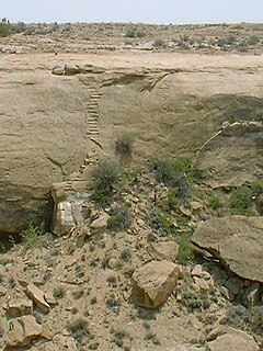
The Jackson Staircase is a pair of Ancestral Puebloan steps cut into the cliff of Chaco Canyon, New Mexico. Located north of Chetro Ketl and east of Pueblo Alto, the stairs gave Chacoans access to the Great North Road. The feature is named after William Henry Jackson, who discovered the stairs in 1877.


