There are several lakes named Mud Lake within the U.S. state of Idaho.

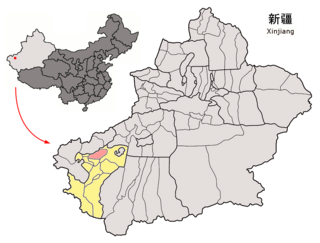
Jiashi County as the official romanized name, also transliterated from Uyghur as Payziwat County, is a county-level administration of Xinjiang Uyghur Autonomous Region and is under the administration of Kashgar Prefecture. It contains an area of 6,528 km2 (2,520 sq mi).

Glenville is a ghost town in Delaware, United States, at 39°42′45″N75°38′24″W. The community consisted of a development on Bread and Cheese Island, on the east bank of the Red Clay Creek near its mouth, just south of Delaware Route 4 near Stanton. Located in the floodplain for Red Clay Creek, the subdivision has always been prone to flooding, such as flooding from Hurricane Floyd in 1999 and Tropical Storm Henri in 2003. After floods caused by Tropical Storm Henri on September 15, 2003, homeowners were bought out by the state and local government, and the community was abandoned in 2004. Demolition began in 2005.

Boves is a railway station located in Boves, France. It is situated on the Paris–Lille railway.

Kinderhook Township is located in Pike County, Illinois. As of the 2010 census, its population was 840 and it contained 422 housing units.

Rivervale is an unincorporated community in Bono Township, Lawrence County, Indiana.
Western district is a district of Plovdiv, southern Bulgaria. The district includes the quarters Proslav, Hristo Smirnenski, Mladeshki Halm and Mladost, and has 39,158 inhabitants. The largest sports complex in Eastern Europe is located in a pleasant park on the southern banks of the Maritsa river. It includes Bulgaria's largest stadium "Plovdiv", rowing base, football terrains, tennis courts, pools as well as cafés, restaurants and places for rest.
Lubania-Lipiny is a village in the administrative district of Gmina Świekatowo, within Świecie County, Kuyavian-Pomeranian Voivodeship, in north-central Poland.

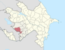
Göyərcık is a village in the Qubadli Rayon of Azerbaijan. Göyərcik is the Azeri village in Qubadli
Nowe Łachy is a village in the administrative district of Gmina Rzewnie, within Maków County, Masovian Voivodeship, in east-central Poland.
Xaspolad is a village in the municipality of Zərqava in the Quba Rayon of Azerbaijan.

Kulik is a settlement in the administrative district of Gmina Pisz, within Pisz County, Warmian-Masurian Voivodeship, in northern Poland.

Arbios is an unincorporated community in Fresno County, California. It is located on the Southern Pacific Railroad 6.5 miles (10 km) south-southeast of Firebaugh, at an elevation of 171 feet.

Konarak County is a county in Sistan and Baluchestan Province in Iran. The capital of the county is Konarak. At the 2006 census, the county's population was 68,605, in 14,288 families. The county is subdivided into two districts: the Central District and Zarabad District. The county has two cities: Konarak & Zarabad.

Nebogovine is a village in the municipality of Višegrad, Bosnia and Herzegovina.

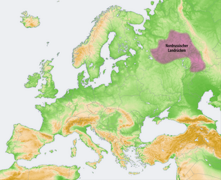
The Northern Ridge, Northern Uvaly, Severnyye Uvaly, is the chain of hills in the northern part of the East European Plain in Russia. The Northern Ridge divides the river basins of the Northern Dvina River (north) and the Volga River (south). The chain is located roughly in the west–east direction, between the source of the Kostroma River and the sources of the Vychegda River and the Kama River. The Northern Ridge is approximately 200 km long. Roughly, the chain is limited from the north by the valleys of the Sukhona and the Vychegda, and from the south by the course of the Volga in the west and by the course of the Kama in the east.

Dabnica is a village in the Municipality of Prilep, North Macedonia.

Tuyyq, also known as Tuyuk, is a town in Almaty Region, southeast Kazakhstan. It lies at an altitude of 1,938 m (6,358 ft).


