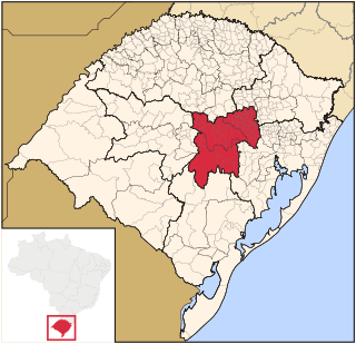
Microregion of Campanha Central

Last updated
Campanha Central
Micro-region
RioGrandedoSul Micro CampanhaCentral.svg
Country Brazil
State Rio Grande do Sul
Mesoregion Sudoeste Rio-Grandense
Municipalities4
Area
  Total 17,296 km2 (6,678 sq mi)

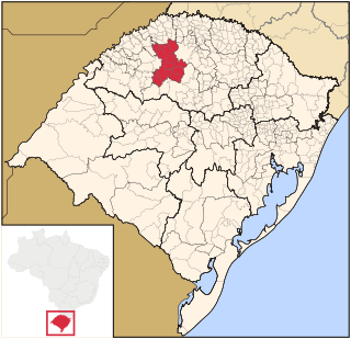
The Campanha Central micro-region (Microrregião de Campanha Central, meaning the central fields in Portuguese) is a microregion in the western part of the state of Rio Grande do Sul, Brazil.

Portuguese language Romance language that originated in Portugal

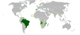
Portuguese is a Western Romance language originating in the Iberian Peninsula. It is the sole official language of Portugal, Brazil, Cape Verde, Guinea-Bissau, Mozambique, Angola, and São Tomé and Príncipe. It also has co-official language status in East Timor, Equatorial Guinea and Macau in China. As the result of expansion during colonial times, a cultural presence of Portuguese and Portuguese creole speakers are also found in Goa, Daman and Diu in India; in Batticaloa on the east coast of Sri Lanka; in the Indonesian island of Flores; in the Malacca state of Malaysia; and the ABC islands in the Caribbean where Papiamento is spoken, while Cape Verdean Creole is the most widely spoken Portuguese-based Creole. Reintegrationists maintain that Galician is not a separate language, but a dialect of Portuguese. A Portuguese-speaking person or nation is referred to as "Lusophone" (Lusófono).

Rio Grande do Sul State of Brazil

Rio Grande do Sul is a state located in the southern region of Brazil. It is the fifth most populous state and the ninth largest by area. Located in the southernmost part of the country, Rio Grande do Sul is bordered clockwise by Santa Catarina to the north and northeast, the Atlantic Ocean to the east, the Uruguayan departments of Rocha, Treinta y Tres, Cerro Largo, Rivera and Artigas to the south and southwest, and the Argentine provinces of Corrientes and Misiones to the west and northwest. The capital and largest city is Porto Alegre. The state has the highest life expectancy in Brazil, and the crime rate is considered to be low.

Brazil Federal republic in South America

Brazil, officially the Federative Republic of Brazil, is the largest country in both South America and Latin America. At 8.5 million square kilometers and with over 208 million people, Brazil is the world's fifth-largest country by area and the fifth most populous. Its capital is Brasília, and its most populated city is São Paulo. The federation is composed of the union of the 26 states, the Federal District, and the 5,570 municipalities. It is the largest country to have Portuguese as an official language and the only one in the Americas; it is also one of the most multicultural and ethnically diverse nations, due to over a century of mass immigration from around the world.

Municipalities

The microregion consists of the following municipalities: [1]

Rosário do Sul Municipality in South, Brazil

Rosário do Sul is a Brazilian municipality in the southwestern part of the state of Rio Grande do Sul. The population is 40,773 in an area of 4,369.65 km². Its elevation is 151 m. It is located 385 km west of the state capital of Porto Alegre. Its main industry is agriculture. Many Argentine and Uruguayan tourists visits during the spring, with a large infrastructure to accommodate the visitors.

Santa Margarida do Sul Municipality in Southern, Brazil

Santa Margarida do Sul is a municipality in the state of Rio Grande do Sul in the Southern Region of Brazil.

Santana do Livramento Municipality in South, Brazil

Santana do Livramento is a city in the state of Rio Grande do Sul, Brazil. It is located along the border with the city of Rivera, Uruguay, forming together an international city of almost 170,000 inhabitants.

Related Research Articles

Aporé Place in Goiás, Brazil

Aporé is a municipality in southwest Goiás state, Brazil. The municipality is a large producer of cattle. Aporé belongs to the Southwest Goiás Microregion.

Microregion of Santiago Micro-region in Rio Grande do Sul, Brazil

The Santiago microregion is a micro-region in the western part of the state of Rio Grande do Sul, Brazil. Its total area is of 11,213.844 km².

Microregion of Campanha Ocidental Micro-region in Rio Grande do Sul, Brazil

The Campanha Ocidental micro-region is a microregion in the western part of the state of Rio Grande do Sul, Brazil. The area is 31,125.429 km² making it the largest micro-region in the state nearly covering one-tenth of the entire state, much of the central and eastern portions remain underpopulated.

Lavras do Sul Municipality in Rio Grande do Sul, Brazil

Lavras do Sul is a Brazilian municipality in the southwestern part of the state of Rio Grande do Sul. It is in the Campanha Meridional micro-region and the Sudoeste Rio-Grandense meso-region. The population is 7,833 in an area of 2600.60 km². The Camaquã River flows through the municipality.

Bandeira do Sul Brazilian municipality located in the state of Minas Gerais

Bandeira do Sul is a Brazilian municipality located in the state of Minas Gerais. Its population as of 2006 is estimated to be 5,490 people living in an altitude between 660 and 989 meters.

Microregion of Jaguarão Microregion in Rio Grande do Sul, Brazil

The Jaguarão microregion is a microregion in the southern part of the state of Rio Grande do Sul, Brazil. Its total area is of 6,331.228 km².

Microregion of Pelotas Micro-region in Rio Grande do Sul, Brazil

The Pelotas Microregion is a microregion in the southeastern part of the state of Rio Grande do Sul, Brazil. The area is 10,306.601 km².

Microregion of Litoral Lagunar Micro-region in Rio Grande do Sul, Brazil

The Litoral Lagunar Microregion is a microregion in the southern part of the state of Rio Grande do Sul, Brazil. Its total area is of 9,379.518 km².

Microregion of Serras de Sudeste Micro-region in Rio Grande do Sul, Brazil

The Serras de Sudeste Microregion is a microregion in the southern part of the state of Rio Grande do Sul, Brazil. It is named after a hill range named Serras de Sudeste, which means Southeastern Mountain Ranges. The area is 16,512.614 km².

Miradouro Brazilian municipality located in the state of Minas Gerais

Miradouro is a Brazilian municipality located in the state of Minas Gerais. The city belongs to the mesoregion of Zona da Mata and to the microregion of Muriaé.

Constantina, Rio Grande do Sul is a municipality in the state of Rio Grande do Sul, Brazil. Founded April 14, 1959. The municipality's motto is "Celeiro da Hospitalidade", meaning "Barn Hospitality".

Fronteira dos Vales Brazilian municipality located in the north-east of the state of Minas Gerais

Fronteira dos Vales is a Brazilian municipality located in the north-east of the state of Minas Gerais. Its population as of 2007 was 4,835 living in a total area of 318 km2 (123 sq mi). The city belongs to the statistical mesoregion of Vale do Mucuri and to the statistical microregion of Nanuque. It became a municipality in 1963.

Microregion of Andradina Microregion in Southeast, Brazil

The Microregion of Andradina is located on the northwest of São Paulo state, Brazil, and is made up of 11 municipalities. It belongs to the Mesoregion of Araçatuba.

Centro Oriental Rio-Grandense Mesoregion in Rio Grande do Sul, Brazil

The Centro Oriental Rio-Grandense is one of the seven Mesoregion of the state of Rio Grande do Sul in Brazil. It consists of 54 municipalities, grouped in three Microregions:

Sudoeste Rio-Grandense Mesoregion in Rio Grande do Sul, Brazil

Sudoeste Rio-Grandense is one of the seven mesoregions of the state of Rio Grande do Sul in Brazil. It consists of 19 municipalities, grouped in three microregions:

Metropolitan Porto Alegre Mesoregion in Rio Grande do Sul, Brazil

Metropolitan Porto Alegre is one of the seven Mesoregions of the state of Rio Grande do Sul in Brazil. It consists of 98 municipalities, grouped in six Microregions:

Sudeste Rio-Grandense Mesoregion in Rio Grande do Sul, Brazil

Sudeste Rio-Grandense is one of the seven Mesoregions of the state of Rio Grande do Sul in Brazil. It consists of 25 municipalities, grouped in four Microregions:

Fazenda da Bica is a region of Rio de Janeiro, but not officially recognized as a neighborhood.

Microregion of Frederico Westphalen Microregion in Rio Grande do Sul, Brazil

The Microregion of Frederico Westphalen was one of the Microregions of the Rio Grande do Sul state, in Brazil. It belonged to the mesoregion of the Noroeste Rio-Grandense. Its population was estimated by the IBGE to be of 175,391 in 2005, divided in 27 municipalities. Its total area is of 5,182.529 km². The IBGE has since discontinued the microregion system for population tracking, replacing it with the term "immediate geographic region".

Microregion of Ijuí Microregion in Rio Grande do Sul, Brazil

The Microregion of Ijuí is one of the Microregions of the Rio Grande do Sul state, in Brazil. It belongs to the mesoregion of the Noroeste Rio-Grandense. Its population was estimated by the IBGE to be of 183.142 inhabitants in 2005, and it is divided in 15 Municipalities. Its total area is of 5.100,402 km².

References

Coordinates: 30°53′27″S55°31′58″W / 30.89083°S 55.53278°W / -30.89083; -55.53278

Geographic coordinate system Coordinate system

A geographic coordinate system is a coordinate system that enables every location on Earth to be specified by a set of numbers, letters or symbols. The coordinates are often chosen such that one of the numbers represents a vertical position and two or three of the numbers represent a horizontal position; alternatively, a geographic position may be expressed in a combined three-dimensional Cartesian vector. A common choice of coordinates is latitude, longitude and elevation. To specify a location on a plane requires a map projection.