Microregion of Serras de Sudeste

Last updated
Serras de Sudeste
Micro-region
RioGrandedoSul Micro SerrasdeSudeste.svg
Country Brazil
State Rio Grande do Sul
Mesoregion Sudeste Rio-Grandense
Municipalities8
Area
  Total 16,513 km2 (6,376 sq mi)

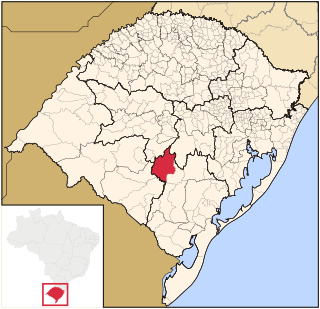
The Serras de Sudeste Microregion (Portuguese: Microrregião das Serras de Sudeste) is a microregion in the southern part of the state of Rio Grande do Sul, Brazil. It is named after a hill range (a plateau) named Serras de Sudeste, which means Southeastern Mountain Ranges. The area is 16,512.614 km².

Rio Grande do Sul State of Brazil

Rio Grande do Sul is a state located in the southern region of Brazil. It is the fifth most populous state and the ninth largest by area. Located in the southernmost part of the country, Rio Grande do Sul is bordered clockwise by Santa Catarina to the north and northeast, the Atlantic Ocean to the east, the Uruguayan departments of Rocha, Treinta y Tres, Cerro Largo, Rivera and Artigas to the south and southwest, and the Argentine provinces of Corrientes and Misiones to the west and northwest. The capital and largest city is Porto Alegre. The state has the highest life expectancy in Brazil, and the crime rate is considered to be low.

Brazil Federal republic in South America

Brazil, officially the Federative Republic of Brazil, is the largest country in both South America and Latin America. At 8.5 million square kilometers and with over 208 million people, Brazil is the world's fifth-largest country by area and the fifth most populous. Its capital is Brasília, and its most populated city is São Paulo. The federation is composed of the union of the 26 states, the Federal District, and the 5,570 municipalities. It is the largest country to have Portuguese as an official language and the only one in the Americas; it is also one of the most multicultural and ethnically diverse nations, due to over a century of mass immigration from around the world.

Plateau An area of a highland, usually of relatively flat terrain

In geology and physical geography, a plateau, also called a high plain or a tableland, is an area of a highland, usually consisting of relatively flat terrain, that is raised significantly above the surrounding area, often with one or more sides with steep slopes. Plateaus can be formed by a number of processes, including upwelling of volcanic magma, extrusion of lava, and erosion by water and glaciers. Plateaus are classified according to their surrounding environment as intermontane, piedmont, or continental.

Municipalities

The microregion consists of the following municipalities: [1]

Amaral Ferrador Municipality in South, Brazil

Amaral Ferrador is a municipality in the state of Rio Grande do Sul, Brazil. The population is 6,778 in an area of 506.46 km². It is situated on the Camaquã River.

Caçapava do Sul Municipality in South, Brazil

Caçapava do Sul is a Brazilian municipality in the state of Rio Grande do Sul, located on the banks of the Camaquã River. As of 2016, the city has an estimated population of 34,664. It was the 2nd capital of the Piratini Republic from 1839 to 1840.

Candiota is a municipality in the state of Rio Grande do Sul, Brazil.

Related Research Articles

São José do Barreiro Municipality in Southeast, Brazil

São José do Barreiro is a municipality in the eastern part of the state of São Paulo, Brazil. The population is 4,185 in an area of 570.69 km².

Subdivisions of Brazil subdivisions of Brazil

Brazil is divided into several types and levels of subdivisions.

Jaguarão River river

The Jaguarão or Yaguarón River is a Brazilian and Uruguayan river. It forms the border between Uruguay and Rio Grande do Sul state in southernmost Brazil.

Maroon-bellied parakeet species of bird

The maroon-bellied parakeet is a small parrot found from southeastern Brazil to north-eastern Argentina, including eastern Paraguay and Uruguay. It is also known as the reddish-bellied parakeet, and in aviculture it is usually referred to as the maroon-bellied conure, reddish-bellied conure or brown-eared conure.

Baependi Brazilian municipality located in the state of Minas Gerais

Baependi is a Brazilian municipality located in the state of Minas Gerais.

Microregion of Jaguarão Microregion in Rio Grande do Sul, Brazil

The Jaguarão microregion is a microregion in the southern part of the state of Rio Grande do Sul, Brazil. Its total area is of 6,331.228 km².

Microregion of Pelotas Micro-region in Rio Grande do Sul, Brazil

The Pelotas Microregion is a microregion in the southeastern part of the state of Rio Grande do Sul, Brazil. The area is 10,306.601 km².

Centro Ocidental Rio-Grandense Mesoregion in Rio Grande do Sul, Brazil

The Centro Ocidental Rio-Grandense is one of the seven mesoregions of the state of Rio Grande do Sul in Brazil. It consists of 31 municipalities, grouped in three microregions:

Pinheiro Machado Municipality in Rio Grande do Sul, Brazil

Pinheiro Machado is a municipality in the state of Rio Grande do Sul, Brazil.

Planalto, Rio Grande do Sul Place in Noroeste Rio-Grandense, Brazil

Planalto is a municipality in the state of Rio Grande do Sul, Brazil, located at 27°19′44″S53°03′31″W, at an altitude of 568 meters above sea level. It has a total area of 237.35 km². Its estimated population in 2004 was of 11,702 inhabitants, and in 2007 it was of 10,589 inhabitants.

Serra do Salitre Brazilian municipality located in the northwest of the state of Minas Gerais

Serra do Salitre is a Brazilian municipality located in the northwest of the state of Minas Gerais. Its population in 2007 was 10,224 living in a total area of 1,298 km². The city belongs to the mesoregion of Triângulo Mineiro e Alto Paranaiba and to the microregion of Patrocínio. It became a municipality in 1953.

Serras de Sudeste

Serras de Sudeste is a dissected plateau, also named Planalto Dissecado de Sudeste or Escudo Sul-Rio-Grandense, located in the southeastern portion of Rio Grande do Sul state in southernmost Brazil, near Uruguay.

MMX is the mining company of the EBX Group founded in 2005. It is engaged in the extraction, beneficiation and sale of iron ore and minerals in Brazil and Chile.

Sudoeste Rio-Grandense Mesoregion in Rio Grande do Sul, Brazil

Sudoeste Rio-Grandense is one of the seven mesoregions of the state of Rio Grande do Sul in Brazil. It consists of 19 municipalities, grouped in three microregions:

Metropolitan Porto Alegre Mesoregion in Rio Grande do Sul, Brazil

Metropolitan Porto Alegre is one of the seven Mesoregions of the state of Rio Grande do Sul in Brazil. It consists of 98 municipalities, grouped in six Microregions:

Sudeste Rio-Grandense Mesoregion in Rio Grande do Sul, Brazil

Sudeste Rio-Grandense is one of the seven Mesoregions of the state of Rio Grande do Sul in Brazil. It consists of 25 municipalities, grouped in four Microregions:

Microregion of Campanha Central Micro-region in Rio Grande do Sul, Brazil

The Campanha Central micro-region is a microregion in the western part of the state of Rio Grande do Sul, Brazil.

Microregion of Frederico Westphalen Microregion in Rio Grande do Sul, Brazil

The Microregion of Frederico Westphalen was one of the Microregions of the Rio Grande do Sul state, in Brazil. It belonged to the mesoregion of the Noroeste Rio-Grandense. Its population was estimated by the IBGE to be of 175,391 in 2005, divided in 27 municipalities. Its total area is of 5,182.529 km². The IBGE has since discontinued the microregion system for population tracking, replacing it with the term "immediate geographic region".

Noroeste Rio-Grandense Mesoregion in Rio Grande do Sul, Brazil

Noroeste Rio-Grandense was one of the seven Mesoregions on the state of Rio Grande do Sul in Brazil. It included 216 municipalities grouped in thirteen microregions.

Microregion of Ijuí Microregion in Rio Grande do Sul, Brazil

The Microregion of Ijuí is one of the Microregions of the Rio Grande do Sul state, in Brazil. It belongs to the mesoregion of the Noroeste Rio-Grandense. Its population was estimated by the IBGE to be of 183.142 inhabitants in 2005, and it is divided in 15 Municipalities. Its total area is of 5.100,402 km².

References

Coordinates: 30°30′43″S53°29′27″W / 30.51194°S 53.49083°W / -30.51194; -53.49083

Geographic coordinate system Coordinate system

A geographic coordinate system is a coordinate system that enables every location on Earth to be specified by a set of numbers, letters or symbols. The coordinates are often chosen such that one of the numbers represents a vertical position and two or three of the numbers represent a horizontal position; alternatively, a geographic position may be expressed in a combined three-dimensional Cartesian vector. A common choice of coordinates is latitude, longitude and elevation. To specify a location on a plane requires a map projection.