Sudeste Rio-Grandense

Last updated
Sudeste Rio-Grandense
Mesoregion
RioGrandedoSul Meso SudesteRioGrandense.svg
Country Brazil
State Rio Grande do Sul
Area
  Total 42,539.66 km2 (16,424.65 sq mi)
Population (2005)
  Total 942,938
  Density 22/km2 (57/sq mi)

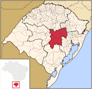
Sudeste Rio-Grandense (Southeast of Rio Grande) is one of the seven Mesoregions of the state of Rio Grande do Sul in Brazil. It consists of 25 municipalities, grouped in four Microregions: [1]

Rio Grande do Sul State of Brazil

Rio Grande do Sul is a state located in the southern region of Brazil. It is the fifth most populous state and the ninth largest by area. Located in the southernmost part of the country, Rio Grande do Sul is bordered clockwise by Santa Catarina to the north and northeast, the Atlantic Ocean to the east, the Uruguayan departments of Rocha, Treinta y Tres, Cerro Largo, Rivera and Artigas to the south and southwest, and the Argentine provinces of Corrientes and Misiones to the west and northwest. The capital and largest city is Porto Alegre. The state has the highest life expectancy in Brazil, and the crime rate is considered to be low.

Brazil Federal republic in South America

Brazil, officially the Federative Republic of Brazil, is the largest country in both South America and Latin America. At 8.5 million square kilometers and with over 208 million people, Brazil is the world's fifth-largest country by area and the fifth most populous. Brazil borders every South American country except Chile and Ecuador. Its capital is Brasília, and its most populated city is São Paulo. The federation is composed of the union of the 26 states, the Federal District, and the 5,570 municipalities. It is the largest country to have Portuguese as an official language and the only one in the Americas; it is also one of the most multicultural and ethnically diverse nations, due to over a century of mass immigration from around the world.

Municipality An administrative division having corporate status and usually some powers of self-government or jurisdiction

A municipality is usually a single urban administrative division having corporate status and powers of self-government or jurisdiction as granted by national and regional laws to which it is subordinate. It is to be distinguished (usually) from the county, which may encompass rural territory or numerous small communities such as towns, villages and hamlets.

Related Research Articles

Jaguarão River river

The Jaguarão or Yaguarón River is a Brazilian and Uruguayan river. It forms the border between Uruguay and Rio Grande do Sul state in southernmost Brazil.

Microregion of Santiago Micro-region in Rio Grande do Sul, Brazil

The Santiago microregion is a micro-region in the western part of the state of Rio Grande do Sul, Brazil. Its total area is of 11,213.844 km².

Microregion of Pelotas Micro-region in Rio Grande do Sul, Brazil

The Pelotas Microregion is a microregion in the southeastern part of the state of Rio Grande do Sul, Brazil. The area is 10,306.601 km².

Microregion of Litoral Lagunar Micro-region in Rio Grande do Sul, Brazil

The Litoral Lagunar Microregion is a microregion in the southern part of the state of Rio Grande do Sul, Brazil. Its total area is of 9,379.518 km².

Microregion of Serras de Sudeste Micro-region in Rio Grande do Sul, Brazil

The Serras de Sudeste Microregion is a microregion in the southern part of the state of Rio Grande do Sul, Brazil. It is named after a hill range named Serras de Sudeste, which means Southeastern Mountain Ranges. The area is 16,512.614 km².

Barão de Cotegipe is a municipality in the state of Rio Grande do Sul, Brazil.

Colorado is a municipality in the state of Rio Grande do Sul, Brazil.

Constantina, Rio Grande do Sul is a municipality in the state of Rio Grande do Sul, Brazil. Founded April 14, 1959. The municipality's motto is "Celeiro da Hospitalidade", meaning "Barn Hospitality".

Entre Rios do Sul is a municipality in the state of Rio Grande do Sul, Brazil.

Marau is a municipality in the state of Rio Grande do Sul, Brazil. It was initially populated by Italian immigrants that were escaping from the war.

Mato Castelhano is a municipality in the state of Rio Grande do Sul, Brazil.

Montauri is a municipality in the state of Rio Grande do Sul, Brazil. As of 2008, it has a population of 1,615 people.

Pinheiro Machado Municipality in Rio Grande do Sul, Brazil

Pinheiro Machado is a municipality in the state of Rio Grande do Sul, Brazil.

Selbach is a municipality in the state of Rio Grande do Sul, Brazil.

Severiano de Almeida is a municipality in the state of Rio Grande do Sul, Brazil.

Roman Catholic Archdiocese of Pelotas archdiocese

The Roman Catholic Archdiocese of Pelotas is an archdiocese located in the city of Pelotas. Before being elevated to an archdiocese in its own right on April 13, 2011 it was part of the Ecclesiastical province of Porto Alegre in Brazil.

Serras de Sudeste

Serras de Sudeste is a dissected plateau, also named Planalto Dissecado de Sudeste or Escudo Sul-Rio-Grandense, located in the southeastern portion of Rio Grande do Sul state in southernmost Brazil, near Uruguay.

Guaporema is a municipality in the state of Paraná in the Southern Region of Brazil.

Centro Oriental Rio-Grandense Mesoregion in Rio Grande do Sul, Brazil

The Centro Oriental Rio-Grandense is one of the seven Mesoregion of the state of Rio Grande do Sul in Brazil. It consists of 54 municipalities, grouped in three Microregions:

References

Coordinates: 31°46′19″S52°20′34″W / 31.7719°S 52.3428°W / -31.7719; -52.3428

Geographic coordinate system Coordinate system

A geographic coordinate system is a coordinate system that enables every location on Earth to be specified by a set of numbers, letters or symbols. The coordinates are often chosen such that one of the numbers represents a vertical position and two or three of the numbers represent a horizontal position; alternatively, a geographic position may be expressed in a combined three-dimensional Cartesian vector. A common choice of coordinates is latitude, longitude and elevation. To specify a location on a plane requires a map projection.