A geographic information system (GIS) consists of integrated computer hardware and software that store, manage, analyze, edit, output, and visualize geographic data. Much of this often happens within a spatial database, however, this is not essential to meet the definition of a GIS. In a broader sense, one may consider such a system also to include human users and support staff, procedures and workflows, the body of knowledge of relevant concepts and methods, and institutional organizations.

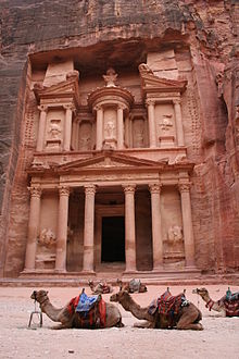
Petra, originally known to its inhabitants as Raqmu or Raqēmō, is a historic and archaeological city in southern Jordan. It is adjacent to the mountain of Jabal Al-Madbah, in a basin surrounded by mountains forming the eastern flank of the Arabah valley running from the Dead Sea to the Gulf of Aqaba. The area around Petra has been inhabited from as early as 7000 BC, and the Nabataeans might have settled in what would become the capital city of their kingdom as early as the 4th century BC. Archaeological work has only discovered evidence of Nabataean presence dating back to the second century BC, by which time Petra had become their capital. The Nabataeans were nomadic Arabs who invested in Petra's proximity to the incense trade routes by establishing it as a major regional trading hub.

An archaeological site is a place in which evidence of past activity is preserved, and which has been, or may be, investigated using the discipline of archaeology and represents a part of the archaeological record. Sites may range from those with few or no remains visible above ground, to buildings and other structures still in use.

ArcGIS is a family of client, server and online geographic information system (GIS) software developed and maintained by Esri. ArcGIS was first released in 1999 and originally was released as ARC/INFO, a command line based GIS system for manipulating data. ARC/INFO was later merged into ArcGIS Desktop, which was eventually superseded by ArcGIS Pro in 2015. ArcGIS Pro works in 2D and 3D for cartography and visualization, and includes artificial Intelligence (AI).
GIS or Geographic Information Systems has been an important tool in archaeology since the early 1990s. Indeed, archaeologists were early adopters, users, and developers of GIS and GIScience, Geographic Information Science. The combination of GIS and archaeology has been considered a perfect match, since archaeology often involves the study of the spatial dimension of human behavior over time, and all archaeology carries a spatial component.
Pennsylvania Spatial Data Access (PASDA) is Pennsylvania's official public access geospatial information clearinghouse. PASDA serves as Pennsylvania's node on the National Spatial Data Infrastructure (NSDI). PASDA is a cooperative effort of the Pennsylvania Geospatial Technologies Office of the Office of Information Technology and the Pennsylvania State University Institutes of Energy and the Environment (PSIEE).
Participatory GIS (PGIS) or public participation geographic information system (PPGIS) is a participatory approach to spatial planning and spatial information and communications management.
Geospatial metadata is a type of metadata applicable to geographic data and information. Such objects may be stored in a geographic information system (GIS) or may simply be documents, data-sets, images or other objects, services, or related items that exist in some other native environment but whose features may be appropriate to describe in a (geographic) metadata catalog.
Traditional knowledge geographic information systems (GIS) are the data, techniques, and technologies designed to document and utilize local knowledges in communities around the world. Traditional knowledge is information that encompasses the experiences of a particular culture or society. Traditional knowledge GIS differ in comparison to ordinary cognitive maps in that they express environmental and spiritual relationships among real and conceptual entities. This toolset focuses on cultural preservation, land rights disputes, natural resource management, and economic development.
The Conservation Geoportal was an online geoportal, intended to provide a comprehensive listing of geographic information systems (GIS) datasets and web map service relevant to biodiversity conservation. It is currently defunct. The site, its contents and functionality were free for anyone to use and contribute to. The Conservation Geoportal was launched on June 28, 2006 at the joint Society for Conservation Biology and Society for Conservation GIS Conference in San Jose, California, USA. As of October 2007, it included metadata for over 3,667 GIS records.
The National Wetlands Inventory (NWI) was established by the United States Fish and Wildlife Service (FWS) to conduct a nationwide inventory of U.S. wetlands to provide biologists and others with information on the distribution and type of wetlands to aid in conservation efforts. To do this, the NWI developed a wetland classification system that is now the official FWS wetland classification system and the Federal standard for wetland classification. The NWI also developed techniques for mapping and recording the inventory findings. The NWI relies on trained image analysts to identify and classify wetlands and deepwater habitats from aerial imagery. NWI started mapping wetlands at a small scale. Eventually, large-scale maps became the standard product delivered by NWI. As computerized mapping and geospatial technology evolved, NWI discontinued production of paper maps in favor of distributing data via online "mapping tools" where information can be viewed and downloaded. Today, FWS serves its data via an on-line data discovery "Wetlands Mapper". GIS users can access wetlands data through an online wetland mapping service or download data for various applications. The techniques used by NWI have recently been adopted by the Federal Geographic Data Committee as the federal wetland mapping standard. This standard applies to all federal grants involving wetland mapping to insure the data can be added to the Wetlands Layer of the National Spatial Data Infrastructure. NWI also produces national wetlands status and trends reports required by the United States Congress.
The Archaeology Data Service (ADS) is an open access digital archive for archaeological research outputs. It is located in The King's Manor, at the University of York. Originally intended to curate digital outputs from archaeological researchers based in the UK's Higher Education sector, the ADS also holds archive material created under the auspices of national and local government as well as in the commercial archaeology sector. The ADS carries out research, most of which focuses on resource discovery, cross-searching and interoperability with other relevant archives in the UK, Europe and the United States of America.

The World Database on Protected Areas (WDPA) is the largest assembly of data on the world's terrestrial and marine protected areas, containing more than 260,000 protected areas as of August 2020, with records covering 245 countries and territories throughout the world. The WDPA is a joint venture between the United Nations Environment Programme World Conservation Monitoring Centre and the International Union for Conservation of Nature World Commission on Protected Areas.
The Directorate-General for Antiquities and Museums (DGAM); Arabic: المديرية العامة للآثار والمتاحف, French: La Direction Générale des Antiquités et des Musées) is a Syrian government owned agency that is responsible for the protection, promotion and excavation activities in all sites of national heritage in the country. The directorate was established shortly after Syria's independence in 1946 under the central supervision of the Ministry of Culture.

Geographic information system (GIS) is a commonly used tool for environmental management, modelling and planning. As simply defined by Michael Goodchild, GIS is as "a computer system for handling geographic information in a digital form". In recent years it has played an integral role in participatory, collaborative and open data philosophies. Social and technological evolutions have elevated digital and environmental agendas to the forefront of public policy, the global media and the private sector.
Assaad Seif is a Lebanese archaeologist and Associate Professor in Archaeology at the Lebanese University. Former Head of the Scientific Departments and coordinator of archaeological research and excavations in Lebanon, at the Directorate General of Antiquities in Beirut.

The conservation and restoration of archaeological sites is the collaborative effort between archaeologists, conservators, and visitors to preserve an archaeological site, and if deemed appropriate, to restore it to its previous state. Considerations about aesthetic, historic, scientific, religious, symbolic, educational, economic, and ecological values all need to be assessed prior to deciding the methods of conservation or needs for restoration. The process of archaeology is essentially destructive, as excavation permanently changes the nature and context of the site and the associated information. Therefore, archaeologists and conservators have an ethical responsibility to care for and conserve the sites they put at risk.
A Collections Management System (CMS), sometimes called a Collections Information System, is software used by the collections staff of a collecting institution or by individual private collectors and collecting hobbyists or enthusiasts. Collecting institutions are primarily museums and archives and cover a very broad range from huge, international institutions, to very small or niche-specialty institutions such as local historical museums and preservation societies. Secondarily, libraries and galleries are also collecting institutions. Collections Management Systems (CMSs) allow individuals or collecting institutions to organize, control, and manage their collections' objects by “tracking all information related to and about” those objects. In larger institutions, the CMS may be used by collections staff such as registrars, collections managers, and curators to record information such as object locations, provenance, curatorial information, conservation reports, professional appraisals, and exhibition histories. All of this recorded information is then also accessed and used by other institutional departments such as “education, membership, accounting, and administration."
The Department of Antiquities is a government department in the Hashemite Kingdom of Jordan with responsibility for archaeological research and cultural heritage management. It is part of the Ministry of Tourism and Antiquities.
Data diplomacy can be defined in two different ways: use of data as a means and tool to conduct national diplomacy, or the use of diplomatic actions and skills of various stakeholders to enable and facilitate data access, understanding, and use. Data can help and influence many aspects of the diplomatic process, such as information gathering, negotiations, consular services, humanitarian response and foreign policy development. The second kind of data diplomacy challenges traditional models of diplomacy and can be conducted without tracks and diplomats. Drivers of change in diplomacy are also emerging from industry, academia and directly from the public.


