Middle Hulton | |
---|---|
Area | |
• 1891 | 1,517 acres (6.14 km2) [1] |
Population | |
• 1801 | 819 |
• 1891 | 2,703 |
History | |
• Created | Middle Ages |
• Abolished | 1898 |
Status | Township (until 1866), Civil parish (1866–1898) |
Middle Hulton was a township of the civil and ecclesiastical parish of Deane in the Salford hundred of Lancashire, England. It was located 3.5 miles (5.6 km) south-west of Bolton. [2]
In England, a township is a local division or district of a large parish containing a village or small town usually having its own church. A township may or may not be coterminous with a chapelry, manor, or any other minor area of local administration.
Deane is an area of Bolton, in Greater Manchester, England. It is about 2 miles (3.2 km) south west of Bolton and 11 miles (17.7 km) northwest of the city of Manchester.
Lancashire is a ceremonial county in North West England. The administrative centre is Preston. The county has a population of 1,449,300 and an area of 1,189 square miles (3,080 km2). People from Lancashire are known as Lancastrians.
The ancient district of Hulton contained three townships, Over Hulton, Middle Hulton and Little Hulton. [3] It was recorded as Helghtun and Hulton in 1235, Hilton in 1278 and 1292 and Hulton in 1292, although Hilton was still used until the 17th century. [4] The chief manor was held by the Hultons at Hulton Park in Over Hulton. [5]
Over Hulton is a suburb of Westhoughton within the Metropolitan Borough of Bolton, in Greater Manchester, England. Historically part of Lancashire, it lies 3.5 miles (5.6 km) south west of Bolton.
Little Hulton is an area within the City of Salford, Greater Manchester, England, 3.4 miles (5.5 km) south of Bolton, 7 miles (11.3 km) west-northwest of Salford, and 9 miles (14.5 km) west-northwest of Manchester. Little Hulton is bordered by Farnworth to the north and Walkden to the east.
The Hulton family of Hulton lived and owned land in Lancashire for more than eight hundred years from the late-12th to the late-20th centuries. The family took its name from the three townships surrounding their Hulton Park Estate, Over, Middle and Little Hulton.
Land belonging to the Hultons was sold to the Earl of Ellesmere. There were coal mines and quarries in the 19th century. It was near the Bolton and Leigh Railway.
Earl of Ellesmere, of Ellesmere in the County of Shropshire, is a title in the Peerage of the United Kingdom. It was created in 1846 for the Conservative politician Lord Francis Egerton. He was granted the subsidiary title of Viscount Brackley, of Brackley in the County of Northampton, at the same time, also in the Peerage of the United Kingdom. Born Lord Francis Leveson-Gower, he was the third son of George Leveson-Gower, 1st Duke of Sutherland and Elizabeth Gordon, 19th Countess of Sutherland. In 1803 his father had inherited the substantial estates of his maternal uncle Francis Egerton, 3rd Duke of Bridgewater. On his father's death in 1833, Lord Francis succeeded to the Egerton estates according to the will of the late Duke of Bridgewater, and assumed by Royal licence the surname of Egerton in lieu of Leveson-Gower. The Brackley and Ellesmere titles created for him in 1846 were revivals of titles held by the Dukes of Bridgewater. In 1963 his great-great-grandson, the fifth Earl, succeeded his kinsman as 6th Duke of Sutherland. The earldom of Ellesmere and viscountcy of Brackley are now subsidiary titles of the dukedom.
The Cutacre site was granted planning permission in 2001 for the surface mining of 900,000 tonnes of coal and reworking of the spoil tip. The operation was expected to last for 4 years and began in 2006. The restoration scheme would create over 100 hectares of amenity woodland and wetlands as well as for an area of industrial development. [6] UK Coal is currently working with Bolton Metropolitan Borough Council to promote the Cutacre site through the Local Development Framework process. Bolton Council have identified Cutacre as a key strategic site for future development in Bolton and consequently plans have changed. There has been a long campaign against the proposals by residents in Over Hulton and Little Hulton. [7]
UK Coal Production Ltd, formerly UK Coal plc, was the largest coal mining business in the United Kingdom. The company was based in Harworth, in Nottinghamshire. The company was a constituent of the FTSE 250 Index. The successor company that contains the former property division, Harworth Group is still listed on the London Stock Exchange.
The Metropolitan Borough of Bolton is a metropolitan borough of Greater Manchester, England. It is named after its largest settlement, the large town of Bolton, but covers a far larger area which includes Blackrod, Farnworth, Horwich, Kearsley and Westhoughton, and a suburban and rural element from the West Pennine Moors. The borough has a population of 276,800, and is administered from Bolton Town Hall.
The former township was situated on the road from Manchester to Preston, now the A6 road. There was no village centre; the most built-up area was in the northern part of the township at Daubhill. [2] It comprises 1,280 acres (5.2 km2) of flat land, mostly of meadow and pasture, the remainder arable. The underlying rocks are Coal Measures; there is also cannel coal and there is a sandstone quarry. The M61 motorway crosses the former township. [5]
Manchester is a city and metropolitan borough in Greater Manchester, England, with a population of 545,500 as of 2017. It lies within the United Kingdom's second-most populous built-up area, with a population of 3.2 million. It is fringed by the Cheshire Plain to the south, the Pennines to the north and east, and an arc of towns with which it forms a continuous conurbation. The local authority is Manchester City Council.
Preston is a city and the administrative centre of Lancashire, England, on the north bank of the River Ribble.
The A6 is one of the main historic north–south roads in England. It currently runs from Luton in Bedfordshire to Carlisle in Cumbria, although it formerly started at a junction with the A1 at Barnet. It is the fourth longest numbered road in Britain, behind only the A1, A38 and A30.
Year | 1801 | 1811 | 1821 | 1831 | 1841 | 1851 | 1861 | 1871 | 1881 | 1891 |
---|---|---|---|---|---|---|---|---|---|---|
Population | 819 | 900 | 938 | 934 | 902 | 888 | 790 | 911 | 2,051 | 2,703 |
Sources: Local population statistics. [8] Vision of Britain. [9] |
Farnworth is a town and an unparished area within the Metropolitan Borough of Bolton in Greater Manchester, England. It is located 2.3 miles (3.7 km) southeast of Bolton, 4.3 miles south-west of Bury (7 km), and 7.5 miles (12.1 km) northwest of Manchester.
Worsley is a town in Greater Manchester, England, which in 2014 had a population of 10,090. It lies along Worsley Brook, 5.75 miles (9.25 km) west of Manchester. The M60 motorway bisects the area.
Kearsley is a town in the Metropolitan Borough of Bolton, Greater Manchester, England. The population at the 2011 census was 14,212. Historically part of Lancashire, it lies 8 miles (13 km) northwest of Manchester, 5 miles (8 km) southwest of Bury and 3 3⁄4 miles (6 km) south of Bolton.
Pendleton is an inner city suburb of Salford, Greater Manchester, England, 2 miles (3.2 km) from Manchester city centre. The A6 dual carriageway skirts the east of the district.
Lostock is a mostly residential district of Bolton in Greater Manchester, England. It lies 3.5 miles (5.6 km) west of Bolton town centre and 18.1 miles (29.1 km) northwest of Manchester. Historically part of Lancashire, Lostock is bounded by Deane to the southeast, Markland Hill to the northeast and the Middlebrook development, including Bolton Wanderers' football ground, the University of Bolton Stadium in nearby Horwich. Lostock, alongside Heaton and Edgworth, is known for being one of the most expensive places to live in Bolton.
Walkden is a suburban town in the City of Salford, Greater Manchester, England, 6 miles (9.7 km) northwest of Salford, and 7 miles (11.3 km) of Manchester.
Heaton is a mostly residential district and council ward of Bolton, Greater Manchester, England. It lies about two miles north west of Bolton town centre. It is bounded by Deane to the south, Markland Hill to the west and Smithills and Halliwell to the north.
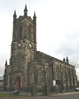
The Municipal Borough of Farnworth was a local government district centred on the town of Farnworth in the administrative county of Greater Manchester, England. A local board of health had been established for Farnworth in 1863, which was reconstituted as an urban district in 1899, before being granted a charter of incorporation to become a municipal borough in 1939. Following abolition of the local authority in 1974, Farnworth became an unparished area of the Metropolitan Borough of Bolton in Greater Manchester.
Rumworth is an electoral ward of Bolton, in Greater Manchester, England. The population of this ward at the 2011 census was 16,250. Historically it was part of the hundred of Salford in Lancashire and centre of the Parish of Deane which once covered roughly half of the present Metropolitan Borough of Bolton. St Mary's Church on which the parish was centred was in the township of Rumworth.
Great Bolton was a township of the civil and ecclesiastical parish of Bolton le Moors in the Salford hundred of Lancashire, England. Despite its name, Great Bolton had a smaller acreage than its northern neighbour Little Bolton from which it was separated by the River Croal.
Longworth was a township of the civil and ecclesiastical parish of Bolton le Moors in the Salford hundred of Lancashire, England.
Sharples, a suburb of Bolton, was a township of the civil and ecclesiastical parish of Bolton le Moors in the Salford hundred of Lancashire, England. It lay 2½ miles north of Bolton. It contained the smaller settlements of Banktop, Sweet-Loves, High-Houses, Gale, Folds, Belmont, Piccadilly, Water-Meetings, Old Houses and part of Astley Bridge.
New Manchester or The City was an isolated mining community on the Manchester Coalfield north of Mosley Common in the Tyldesley township, England. It lies west of a boundary stone at Ellenbrook which marks the ancient boundary of the Hundreds of Salford and West Derby, the boundary of Eccles and Leigh ecclesiastical parishes, Tyldesley, Worsley and Little Hulton townships and the metropolitan districts of Wigan and Salford. The route of the Roman road from Manchester to Wigan and the Tyldesley Loopline passed south of the village. The Lancashire and Yorkshire Railway's Manchester to Southport line passed to the north.
Horwich was, from 1872 to 1974, a local government district centred on the town of Horwich in the administrative county of Lancashire, England.
Kearsley was, from 1865 to 1974, a local government district centred on the town of Kearsley in the administrative county of Lancashire, England.
Westhoughton was, from 1872 to 1974, a local government district centred on the town of Westhoughton in the administrative county of Lancashire, England.
Notes
Coordinates: 53°32′N2°27′W / 53.54°N 2.45°W
A geographic coordinate system is a coordinate system that enables every location on Earth to be specified by a set of numbers, letters or symbols. The coordinates are often chosen such that one of the numbers represents a vertical position and two or three of the numbers represent a horizontal position; alternatively, a geographic position may be expressed in a combined three-dimensional Cartesian vector. A common choice of coordinates is latitude, longitude and elevation. To specify a location on a plane requires a map projection.