Nienburg is a district (Landkreis) in Lower Saxony, Germany. It is bounded by the districts of Diepholz, Verden, Heidekreis, Hanover and Schaumburg, and by the state of North Rhine-Westphalia.
Schaumburg is a district (Landkreis) of Lower Saxony, Germany. It is bounded by the districts of Nienburg, Hanover and Hamelin-Pyrmont, and the state of North Rhine-Westphalia.
Minden-Lübbecke is a Kreis (district) in the northeastern part of North Rhine-Westphalia, Germany. Neighboring districts are Diepholz, Nienburg, Schaumburg, Lippe, Herford, Osnabrück.

Porta Westfalica is a town in the district of Minden-Lübbecke, in North Rhine-Westphalia, Germany.
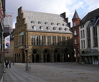
Minden is a middle-sized town in the very north-east of North Rhine-Westphalia, Germany, the largest town in population between Bielefeld and Hanover. It is the capital of the district (Kreis) of Minden-Lübbecke, which is part of the region of Detmold. The town extends along both sides of the River Weser, and is crossed by the Mittelland Canal, which is passing the river on the Minden Aqueduct.

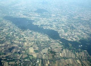
The Wiehen Hills are a hill range in North Rhine-Westphalia and Lower Saxony in Germany. The hills run from west to east like a long finger away from the main upland area of the Lower Saxon Hills, beginning at the Weser River near Minden and terminating in the vicinity of Osnabrück. It is the northernmost of the German Central Upland ranges extending into the Northern Lowlands. Their highest hill is the Heidbrink near Lübbecke with an altitude of 320 metres (1,050 ft).

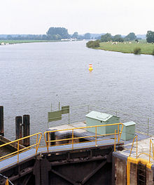
The Porta Westfalica, also known as the Westphalian Gap, is a gorge and water gap where the Weser river breaks through the passage between the mountain chains of the Wiehen Hills in the west and the Weser Hills in the east. It is located in the district of Minden-Lübbecke in North Rhine-Westphalia, Germany.

The Weser Hills (Wesergebirge), also known in German as the Weserkette, form a low hill chain, up to 326.1 m above sea level (NN), in the Weser Uplands in the German states of North Rhine-Westphalia and Lower Saxony.
The Wittekindsberg is a hill, 281.48 m above sea level (NN), which forms the easternmost peak of the Wiehen Hills and is also the western guardian of the Weser gorge, the Porta Westfalica, in North Rhine-Westphalia (Germany).

The Upper Weser Valley in central Germany has been formed by the Upper Weser river cutting through the Weser Uplands for around 200 kilometres (120 mi) between the towns of Hann. Münden and Minden. It lies in the German federal states of Lower Saxony, Hesse and North Rhine-Westphalia.
Weser Valley may refer to:

The Weser Depression or Weser Lowlands is the region north of Porta Westfalica in Germany, where the River Weser no longer flows through a valley, but a broad plain consisting of meadows and river terraces.
The Middle Weser Region includes, in its fullest sense, the land along the Middle Weser between Minden and Bremen. It lies within the federal states of North Rhine-Westphalia, Lower Saxony and Bremen. However, the term is often used just to refer to the Lower Saxon part, because of the different political development of the three states and the cooperative associations formed in Lower Saxony some years ago. The Lower Saxon part of the Middle Weser Region forms the geographical heart of this state. In the centre of the Middle Weser Region are the towns of Minden, Nienburg/Weser and Verden (Aller). In the extreme north, the city of Bremen, which is not part of Lower Saxony, has a very important influence on that area of Lower Saxony surrounding it.
The Rahden-Diepenau Geest is a natural region in the extreme northeast of North Rhine-Westphalia and in the neighbouring state of Lower Saxony in north Germany. It includes the overwhelmingly gently rolling geest between the Lübbecker Lößland to the south, the Diepholz Moor Depression to the north, the Middle Weser Valley to the east and the western Wiehen Hills and Bersenbrück Land to the west. The Rahden-Diepenau Geest is part of the Dümmer Geest Depression and thus belongs to the North German Plain, although they include foothills of the Central Uplands in the shape of the Stemmer Berge.
The Schaumburg Forest is a wooded region, about 80 m above sea level (NN) with an area of around 40 km², in the district of Schaumburg in the German federal state of Lower Saxony.

Minden Land is a cultural landscape in East Westphalia, the northeastern part of North Rhine-Westphalia in Germany. It covers the four-fifths of the district of Minden-Lübbecke that lie on the North German Plain and is clearly bounded to the south by the Weser Hills and Wiehen Hills, where it adjoins the Ravensberg Land and the Upper Weser Valley. Its other boundaries are delineated by those of the district.

The Westphalian Mill Route is a circular, long-distance, cycle route in the German district of Minden-Lübbecke and its neighbouring areas in North Rhine-Westphalia. The route is laid out in such a way as to take in 43 historic mills along a circular route of about 320 kilometres.

The Weser-Leine-Express is the name used in North Rhine-Westphalia (NRW) for a Regional-Express service that connects the east Westphalian regional centre of Bielefeld and Minden and the Lower Saxony regional centres of Hanover and Braunschweig. The NRW government found that there was sufficient state interest for it to support operations on the section in that state. The service alternates with the Ems-Leine-Express, which connects Rheine with Minden and Braunschweig. The border between North Rhine-Westphalia and Lower Saxony Between is crossed between Minden and Bückeburg.

The Emperor William Monument, near the town of Porta Westfalica in the North Rhine-Westphalian county of Minden-Lübbecke, is a colossal monument above the Weser gorge of Porta Westfalica, the "Gateway to Westphalia". It was erected to honour the first German Emperor, William I (1797–1888), by the then Prussian Province of Westphalia between 1892 and 1896 and emerged against the background of a rising German national identity. The monument, which is around 88 metres (289 ft) high, is classified as one of Germany's national monuments.
The Dümmer Geest Lowland is a natural region unit of the 3rd level in northwest Germany that mainly extends over southwestern Lower Saxony with a small area over the border in North Rhine-Westphalia. Its uniqueness consists in the very varied juxtaposition of different landscape elements of the Northern Lowlands of which the Dümmer Geest Lowland is a part.