
Westchester County is located in the U.S. state of New York. It is the seventh most populous county in the State of New York and the most populous north of New York City. According to the 2020 United States Census, the county had a population of 1,004,456, its highest decennial count ever and an increase of 55,344 (5.8%) from the 949,113 counted in 2010. Westchester covers an area of 450 square miles (1,200 km2), consisting of six cities, 19 towns, and 23 villages. Established in 1683, Westchester was named after the city of Chester, England. The county seat is the city of White Plains, while the most populous municipality in the county is the city of Yonkers, with 211,569 residents per the 2020 census. The county is part of the Hudson Valley region of the state.
Middletown is a town in Delaware County, New York, United States. The population was 3,336 at the 2020 census. The town is in the southeastern part of the county.

Middletown is the largest city in Orange County, New York, United States. It lies in New York's Hudson Valley region, near the Wallkill River and the foothills of the Shawangunk Mountains. Middletown is situated between Port Jervis and Newburgh, New York. At the 2020 United States census, the city's population was 30,345, reflecting an increase of 2,259 from the 28,086 counted in the 2010 census. The zip code is 10940. Middletown falls within the Kiryas Joel–Poughkeepsie–Newburgh Metropolitan Statistical Area, which belongs to the larger New York–Newark–Bridgeport, NY–NJ–CT–PA Combined Statistical Area.

Wallkill is a town in Orange County, New York, United States. The population was 30,486 at the 2020 census. It is centrally located in the county. Interstate 84 crosses New York State Route 17 in the southern part of the town. U.S. Route 6 and New York State routes 17K, 211 and 302 also cross portions of the town.
Halfmoon is a town in Saratoga County, New York, United States. The population was 25,662 at the 2020 census. The town is apparently named for the shape of the lower elevation land north of the junction of the Hudson and Mohawk Rivers. It is also said to be named for Henry Hudson's ship, the Halve Maen.

Warwick is a town in the southwestern part of Orange County, New York, United States. Its population was 32,027 at the 2020 census. The town contains three villages and eight hamlets.
Southern Westchester refers to the southern portion of Westchester County, New York, a dense inner-ring suburban area north of New York City.

New York State Route 97 (NY 97) is a 70.53-mile-long (113.51 km) north–south scenic route in southern New York in the United States. It runs from U.S. Route 6 (US 6) and US 209 in Port Jervis to NY 17 in Hancock. Its most famous feature is the Hawk's Nest, a tightly winding section of the road along the Delaware River, located a few miles north of Port Jervis. NY 97 intersects NY 52 in Narrowsburg and indirectly connects to three Pennsylvania state highways due to its proximity to the state line.

New York State Route 302 (NY 302) is a state highway in northern Orange County, New York, in the United States. The southern terminus of the route is at an intersection with NY 17M north of the city of Middletown in the town of Wallkill. Its northern terminus is at a junction with NY 52 in the hamlet of Pine Bush, located within the town of Crawford.

New York State Route 211 (NY 211) is a state highway located entirely within Orange County, New York, in the United States. The western terminus is at the intersection with US 209 located in Cuddebackville, and the eastern terminus is located at Montgomery at NY 17K, where it becomes the main thoroughfare.

New York State Route 284 (NY 284) is a north–south state highway located entirely within Orange County, New York, in the United States. It begins just south of the village of Unionville at the New Jersey state line in the town of Minisink, where it connects to that state's Route 284. From Unionville, the route heads through rural parts of Orange County for just over 9 miles (14 km) to an intersection with U.S. Route 6 (US 6) in the hamlet of Slate Hill, located 5 miles (8.0 km) southwest of the city of Middletown in the town of Wawayanda.

Campbell Hall station is a commuter rail stop on the Metro-North Railroad's Port Jervis Line, located just south of the hamlet of Campbell Hall, New York in the town of Hamptonburgh. The station is located at the end of Watkins Road, off Egbertson Road. The station contains decorative lights, a long platform roof and an elevated mini-high platform at the east end of the station for access by riders in wheelchairs. Parking is on a permit/meter system.

Middletown–Town of Walkill station, often just referred to as the Middletown station, is a stop on the Metro-North Railroad's Port Jervis Line in the town of Wallkill, New York. The station is located in the latter municipality along the former Erie Railroad Graham Line. Two trains end at the station on weekdays, with one of them turning back for service to Hoboken. The station contains a mini-high platform for access by passengers in wheelchairs, and expanded paid parking. In a switch from the other stations to receive these amenities, the platform roof at Middletown is green rather than red, platform light poles are brown instead of green and the wheelchair platform is not under the roof. While other Metro-North stations such as Cortlandt and Southeast are named after the towns in which they are located, the station is the only one to include "Town of ..." in its official name, to avoid longstanding confusion with the nearby hamlet in Ulster County.

The Wallkill Valley Rail Trail is a 23.7-mile (38.1 km) rail trail and linear park that runs along the former Wallkill Valley Railroad rail corridor in Ulster County, New York, United States. It stretches from Gardiner through New Paltz, Rosendale and Ulster to the Kingston city line, just south of a demolished, concrete Conrail railroad bridge that was located on a team-track siding several blocks south of the also-demolished Kingston New York Central Railroad passenger station. The trail is separated from the Walden–Wallkill Rail Trail by two state prisons in Shawangunk, though there have been plans to bypass these facilities and to connect the Wallkill Valley Rail Trail with other regional rail-trails. The northern section of the trail forms part of the Empire State Trail.
Arkville is a hamlet in the Town of Middletown, Delaware County, New York, United States. It is located along New York State Route 28, one mile north of the village of Margaretville in the western Catskill Mountains. It has the ZIP code 12406.

The Walden–Wallkill Rail Trail, also known as the Jesse McHugh Rail Trail, is a 3.22-mile (5.18 km) rail trail between the village of Walden, New York and the neighboring hamlet of Wallkill. The two communities are located in Orange and Ulster counties, respectively, in upstate New York.

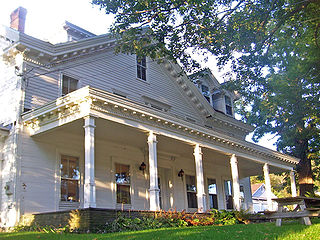
This is a list of the National Register of Historic Places listings in southern Westchester County, New York, excluding the cities of New Rochelle and Yonkers, which have separate lists of their own.
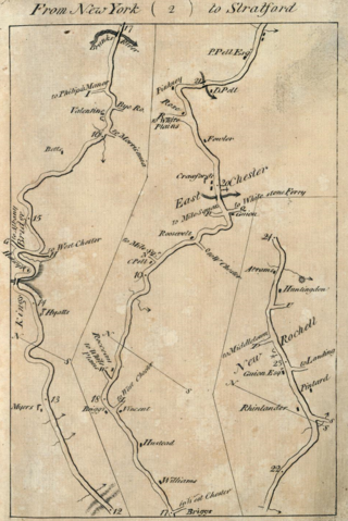
Middletown is a former hamlet of the Town of New Rochelle in Westchester County, New York. The hamlet took shape in the central portion of New Rochelle, extended along North Avenue from the vicinity of Rochelle Park to the southerly boundary of the Wykagyl Country Club grounds. The origin of the name is traceable to a division of the town road districts. As early as 1747, there were two main districts: "upper" and "below". An increase in population after the Revolutionary War warranted the further subdivision of the town into five road districts in 1787. One was named "Middle" to distinguish it from the "Upper", "Waterside" and "Town" districts. By this time the district had become quite well built up so as to make the term "town" appropriate. Hence it became "Middletown". The name was so appropriate to the hamlet that it was indicated on road maps beginning in 1789.

Beechmont is an upscale residential community located in the northern end of New Rochelle in Westchester County, New York. Its boundaries are the Town of Mamaroneck on the east, Iona College, Sunset View Park, and City Park on the south, by Huguenot Park on the west and by Forest Heights, Larchmont Woods, and Bayberry on the north. Beechmont is within the larger Wykagyl sub-section of New Rochelle, served by the 10804 zip-code. The United States Board on Geographic Names recognizes Beechmont as the official common name for the neighborhood, which it defines as a populated place existing within the incorporated City of New Rochelle.