
The Vaal River is the largest tributary of the Orange River in South Africa. The river has its source near Breyten in Mpumalanga province, east of Johannesburg and about 30 kilometres (19 mi) north of Ermelo and only about 240 kilometres (150 mi) from the Indian Ocean. It then flows westwards to its confluence with the Orange River southwest of Kimberley in the Northern Cape. It is 1,458 kilometres (906 mi) long, and forms the border between Mpumalanga, Gauteng and North West Province on its north bank, and the Free State on its south.

KwaZulu-Natal is a province of South Africa that was created in 1994 when the government merged the Zulu bantustan of KwaZulu and Natal Province.
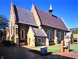
Pietermaritzburg is the capital and second-largest city in the province of KwaZulu-Natal, South Africa after Durban. It was named in 1838 and is currently governed by the Msunduzi Local Municipality. The town was named in Zulu after King Dingane's royal homestead uMgungundlovu. Pietermaritzburg is popularly called Maritzburg in Afrikaans and is often informally abbreviated to PMB. It is a regionally important industrial hub, producing aluminium, timber and dairy products, as well as the main economic hub of uMgungundlovu District Municipality. The public sector is a major employer in the city due to local, district and provincial government offices located here.

Ladysmith is a city in the Uthukela District of KwaZulu-Natal, South Africa. It lies 230 kilometres (140 mi) north-west of Durban and 365 kilometres (227 mi) south-east of Johannesburg. Important industries in the area include food processing, textiles, and tyre production. Ladysmith is the seat for both the Alfred Duma Local Municipality and Uthukela District Municipality.

The Tugela River is the largest river in KwaZulu-Natal Province, South Africa. With a total length of 560 km (350 mi), and a drop of 1 370 metres in the lower 480 km, it is one of the most important rivers of the country.

The Vaal Dam in South Africa was constructed in 1938 and lies 77 km south of OR Tambo International Airport, Johannesburg. The lake behind the dam wall has a surface area of about 320 square kilometres (120 sq mi) and is 47 meters deep. The Vaal Dam lies on the Vaal River, which is one of South Africa's strongest-flowing rivers. Other rivers flowing into the dam are the Wilge River, Molspruit and Grootspruit. It has over 800 kilometres (500 mi) of shoreline and is South Africa's second biggest dam by area and the fourth largest by volume.

Newcastle is the third-largest city in the province of KwaZulu-Natal, South Africa and is the province's industrial centre. The city has four industrial areas. Newcastle is known as the "New City" The majority of its citizens reside in Newcastle East in the main townships of Madadeni and Osizweni, with the balance residing in Newcastle West. Set at the foothills of the northern KwaZulu-Natal Drakensberg Mountains, Newcastle is located in the northwest corner of the province along the Ncandu River.

Amanzimtoti, locally nicknamed Toti, and officially renamed to eManzimtoti, is a coastal town just south of Durban in KwaZulu-Natal, South Africa. Situated along the Sapphire Coast, the town is well known for its warm climate and numerous beaches, and is a popular tourist destination, particularly with surfers.

The Umgeni River or Mgeni River is a river in KwaZulu-Natal, South Africa. It rises in the "Dargle" in the KZN Midlands, and its mouth is at Durban, some distance north of Durban's natural harbour. It is generally agreed its name means "the river of entrance" in Zulu, though other meanings have been suggested.
The Midmar Mile is a swimming race held annually in February at the Midmar Dam north of Pietermaritzburg, South Africa. Each year, it draws thousands of competitors, from serious international athletes and Olympic medallists to purely recreational swimmers. The inaugural Midmar Mile was held in 1974.
Howick High School is a coeducational public school in Howick, KwaZulu-Natal, South Africa, established on 27 June 1967. Whilst it has a weekly boarding facility, known as Midmar House, which can accommodate up to 100 students who live in the local surrounding districts, Howick High School is not a full-time boarding school.
Midmar Nature Reserve, also known as Midmar Dam Nature Reserve, is a protected area around Midmar Dam on the Umgeni River. It is situated near to Howick in KwaZulu-Natal, South Africa.
Albert Falls Dam is a dam in the Umgeni River, just outside Pietermaritzburg, KwaZulu-Natal, South Africa. Established in 1976, the dam has a gross capacity of 290.1 million cubic meters and a surface area of 23.521 square kilometres (9.082 sq mi). The dam wall is 33 metres (108 ft) high.

Nagle Dam is a mass concrete type dam located on the Mgeni River, near Cato Ridge, KwaZulu-Natal, South Africa. It was established in 1950 and serves mainly for municipal and industrial purposes. The hazard potential of the dam has been ranked high (3).
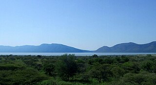
Pongolapoort Dam, commonly referred to as Jozini Dam creating Lake Jozini, is an arch type dam in northern KwaZulu-Natal, South Africa located on the Phongolo River. The dam is situated just north of the settlement of Jozini, 280 km north-east of the port city of Durban. The dam was constructed in 1973 at the eastern end of the narrow gorge separating the Lebombo and Ubombo ranges. The dam mainly serves for irrigation purposes and its hazard potential has been ranked high (3). The Phongolo River is the dam's largest feeder and outlet as well as the dam's only perennial feeder.

The Wagendrift Dam is a multi-arch type dam located on the Bushman's River, upstream of Estcourt, in the KwaZulu-Natal province of South Africa. It was completed in 1963 and serves mainly for irrigation purposes, domestic water supply and industrial demands. The hazard potential of the dam has been ranked high (3).
Zaaihoek Dam is a gravity type dam located on the Slang River in Kwazulu-Natal Province of South Africa. The dam, which has a 185,000,000 m3 capacity, was built in 1988. The dam primarily provides water for industrial and municipal uses. Its hazard potential has been ranked high (3). It is 39.45 km(24.5 mi) long. It is somewhat known for fishing.

The uMkhomazi River is a river in KwaZulu-Natal, South Africa.

In April 2022, days of heavy rain across KwaZulu-Natal in southeastern South Africa led to deadly floods. Particularly hard-hit were areas in and around Durban. At least 436 people died across the province, with an unknown number of people missing as of April 22. Several thousand homes were damaged or destroyed. Critical infrastructure, including major roads, transportation, communication, and electrical systems, were also impacted by the flooding, and this damage greatly hampered recovery and relief efforts. It is one of the deadliest disasters in the country in the 21st century, and the deadliest storm since the 1987 floods. The floods have caused more than R17 billion in infrastructure damage. A national state of disaster was declared.

