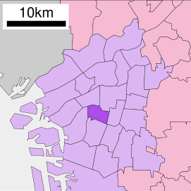
Naniwa-ku (浪速区) is one of 24 wards of Osaka, Japan. It has an area of 4.37 km², and a population of 51,567.

Shuifu is a county-level city under the jurisdiction of the prefecture-level city of Zhaotong, in the northeast of Yunnan province, China, bordering Sichuan to the east and northeast across the Jinsha River.
Murieta is a town and municipality located in the province and autonomous community of Navarre, northern Spain. It covers an area of 4,51 km². In 2006, it had a population of 371, giving the average population density of 70,29 persons per km².

Grabowno Wielkie is a village in the administrative district of Gmina Twardogóra, within Oleśnica County, Lower Silesian Voivodeship, in south-western Poland. Prior to 1945 it was in Germany.
Smogorzówek is a village in the administrative district of Gmina Wińsko, within Wołów County, Lower Silesian Voivodeship, in south-western Poland. Prior to 1945 it was in Germany.

Zarishat is a village in the Shirak Province of Armenia.

Słucz-Kolonie is a village in the administrative district of Gmina Radziłów, within Grajewo County, Podlaskie Voivodeship, in north-eastern Poland. It lies approximately 4 kilometres (2 mi) west of Radziłów, 27 km (17 mi) south of Grajewo, and 64 km (40 mi) north-west of the regional capital Białystok.
Kalinówka is a village in the administrative district of Gmina Głusk, within Lublin County, Lublin Voivodeship, in eastern Poland.
Borkowizna is a village in the administrative district of Gmina Strzyżewice, within Lublin County, Lublin Voivodeship, in eastern Poland.

Mirzəqasım is a village in the Quba Rayon of Azerbaijan. The village forms part of the municipality of Hacıqaib.
Andrzejówka is a village in the administrative district of Gmina Złoczew, within Sieradz County, Łódź Voivodeship, in central Poland. It lies approximately 5 kilometres (3 mi) east of Złoczew, 21 km (13 mi) south of Sieradz, and 69 km (43 mi) south-west of the regional capital Łódź.
Nepomucenów is a village in the administrative district of Gmina Budziszewice, within Tomaszów Mazowiecki County, Łódź Voivodeship, in central Poland. It lies approximately 4 kilometres (2 mi) east of Budziszewice, 16 km (10 mi) north of Tomaszów Mazowiecki, and 39 km (24 mi) east of the regional capital Łódź.
Przymiarki is a village in the administrative district of Gmina Ulhówek, within Tomaszów Lubelski County, Lublin Voivodeship, in eastern Poland, close to the border with Ukraine. It lies approximately 4 km (2 mi) south of Ulhówek, 26 km (16 mi) east of Tomaszów Lubelski, and 126 km (78 mi) south-east of the regional capital Lublin.
Rochy is a settlement in the administrative district of Gmina Zduny, within Krotoszyn County, Greater Poland Voivodeship, in west-central Poland. It lies approximately 6 kilometres (4 mi) west of Zduny, 10 km (6 mi) west of Krotoszyn, and 87 km (54 mi) south of the regional capital Poznań.
Dobrojewo is a village in the administrative district of Gmina Ostroróg, within Szamotuły County, Greater Poland Voivodeship, in west-central Poland. It lies approximately 4 kilometres (2 mi) west of Ostroróg, 13 km (8 mi) north-west of Szamotuły, and 44 km (27 mi) north-west of the regional capital Poznań.
Janiszowice is a village in the administrative district of Gmina Brody, within Żary County, Lubusz Voivodeship, in western Poland, close to the German border.
Bukowa Góra Cashubian Bùkòwô Gòra),(German: Bukowagorra) is a settlement in the administrative district of Gmina Kartuzy, within Kartuzy County, Pomeranian Voivodeship, in northern Poland.
Kalkowo is a village in the administrative district of Gmina Gołdap, within Gołdap County, Warmian-Masurian Voivodeship, in northern Poland, close to the border with the Kaliningrad Oblast of Russia. It lies approximately 8 kilometres (5 mi) south-east of Gołdap and 138 km (86 mi) north-east of the regional capital Olsztyn.
Bougous is a town and commune in El Taref Province, Algeria. According to the 1998 census it has a population of 10,576.

Alnarpsströmmen is a subterranean aquifer under the Swedish province of Skåne. It has been used for wells since at least the 18th century and as a fresh water source for Malmö since 1901. Several other towns use it today. Due to its artesian character, wells occasionally turn to fountains. About 400 litres of groundwater naturally flow into Öresund from Alnarpsströmmen every second through quaternary moraine. The width of the aquifer is around 20 km, and the flow of the water is just 10 metres a year.


