Mike Turtur Bikeway

Last updated

Mike turtur bikeway
Length9.8 kilometres (6.1 mi) [1]
Location Adelaide, South Australia
Trailheads Glenelg, King William Street, Adelaide
UseCycling, walking
Hiking details
Seasonall
Surface bitumen, pavers

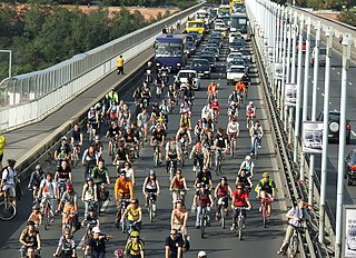
The Mike Turtur Bikeway is a cycling route adjacent to the Glenelg tram route connecting Glenelg to the Adelaide city centre. It is a popular commuter route for people who live in the inner suburbs southwest of the city and work in or near the city centre. [2]

Glenelg, South Australia Suburb of Adelaide, South Australia

Glenelg is a beach-side suburb of the South Australian capital of Adelaide. Located on the shore of Holdfast Bay in Gulf St Vincent, it has become a tourist destination due to its beach and many attractions, home to several hotels and dozens of restaurants.

Adelaide city centre Suburb of Adelaide, South Australia

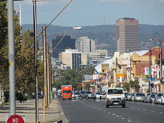
Adelaide city centre is the inner city locality of Greater Adelaide, the capital city of South Australia. It is known by locals simply as "The City" or "Town" to distinguish it from Greater Adelaide and from the City of Adelaide local government area. Due to the construction of many new apartments in the city, the population has grown over ten years from 10,229 to 15,115.

The bikeway was named in 2010 in honour of Michael Turtur, an Olympic cycling gold medallist from Adelaide. [2] As of 2016 it ends at South Terrace, Adelaide on the edge of the city centre. The state government and Adelaide City Council are seeking to design a bikeway along King William Street to extend it in to Victoria Square in the heart of the city. [3]

Michael Colin Turtur is a former track cyclist and Olympic gold medallist in the 4000m Team Pursuit at the 1984 Olympics in Los Angeles, with team members Dean Woods, Kevin Nichols and Michael Grenda, coached by Charlie Walsh.

South Terrace, Adelaide road in Adelaide, South Australia

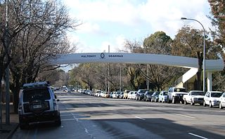
South Terrace is one of the four terraces which bound the city centre of Adelaide, the capital of South Australia.

Government of South Australia state government of South Australia

The Government of South Australia, also referred to as the South Australian Government, SA Government or Her Majesty’s Government is the Australian state democratic administrative authority of South Australia. The Government of South Australia, a parliamentary constitutional monarchy, was formed in 1856 as prescribed in its Constitution, as amended from time to time. Since the Federation of Australia in 1901, South Australia has been a state of the Commonwealth of Australia, and the Constitution of Australia regulates its relationship with the Commonwealth. Under the Australian Constitution, South Australia ceded legislative and judicial supremacy to the Commonwealth, but retained powers in all matters not in conflict with the Commonwealth.

As the bikeway is becoming more popular, a number of infrastructure improvements have been made or proposed to improve the safety and utility of the sections that were poorest. The most significant was a bridge over South Road, though this was closed for about 12 months in 2017-2018 due to structural problems; it re-opened in January 2018. Crossing lights for cyclists were added at Goodwood Road and improved at South Terraced. [3] In a number of places, there is an improved shared path where cyclists previously needed to use a parallel street. [1] In conjunction with other rail upgrades, a bridge is planned over the Seaford and Belair railway lines at Goodwood railway station. [3]

Seaford railway line

The Seaford railway line is a suburban commuter line in Adelaide, South Australia.

Belair railway line suburban rail commuter route within the City of Adelaide, South Australia, Australia

The Belair railway line is a suburban rail commuter route in the city of Adelaide, South Australia, that runs from the Adelaide station to Belair in the Adelaide Hills via the Adelaide-Wolseley line.

Goodwood railway station railway station in Adelaide, South Australia

Goodwood railway station is the junction station for the Belair and Seaford/Tonsley lines. The Belair line diverges south-east towards Millswood, while the Seaford and Tonsley lines diverge south-west towards Clarence Park. The Glenelg Tram line crosses over the railway lines at the south end of Goodwood station. The station services the Adelaide inner-southern suburb of Goodwood, and is 5.0 km from Adelaide station.

Related Research Articles

Bike path bikeway separated from motorized traffic and dedicated to cycling or shared with pedestrians or other non-motorized users

A bike path is a bikeway separated from motorized traffic and dedicated to cycling or shared with pedestrians or other non-motorized users. In the US a bike path sometimes encompasses shared use paths, "multi-use path", or "Class III bikeway" is a paved path that has been designated for use by cyclists outside the right of way of a public road. It may or may not have a center divider or stripe to prevent head-on collisions. In the UK, a shared-use footway or multi-use path is for use by both cyclists and pedestrians.

Adelaide Metro South Australian public transport authority

Adelaide Metro is the public transport system of Adelaide, the capital city of South Australia. It is an intermodal system offering an integrated network of bus, tram, and train service throughout the metropolitan area to 63 million riders annually, with an average daily ridership of 173,000 people. The system has evolved heavily over the past fifteen years, and patronage increased dramatically during the 2014–15 period, a 5.5 percent increase on the 2013 figures due to electrification of frequented lines.

Adelaide railway station railway station in Adelaide, South Australia

Adelaide Railway Station is the central terminus of the Adelaide Metro railway system. All lines approach the station from the west, and it is a terminal station with no through lines, with most of the traffic on the metropolitan network either departing or terminating here. It has nine platforms, all using broad gauge track. It is located on the north side of North Terrace, west of Parliament House. The Adelaide Casino occupies part of the building that is no longer required for railway use. Until 1984, Adelaide station was also the terminus for regional and interstate passenger trains, but there are no longer any regular regional train services in South Australia, and all interstate services are now handled at Adelaide Parklands Terminal.

Glenelg tram line

The Glenelg Tram is a light rail line in Adelaide. Apart from a short street-running section in Glenelg, the line has its own reservation, with minimal interference from road traffic.

Bicycle transportation planning and engineering

Bicycle transportation planning and engineering are the disciplines related to transportation engineering and transportation planning concerning bicycles as a mode of transport and the concomitant study, design and implementation of cycling infrastructure. It includes the study and design of dedicated transport facilities for cyclists as well as mixed-mode environments and how both of these examples can be made to work safely. In jurisdictions such as the United States it is often practiced in conjunction with planning for pedestrians as a part of active transportation planning.

Wayville, South Australia Suburb of Adelaide, South Australia

Wayville is an inner-southern suburb of Adelaide in the City of Unley. It is most notable for hosting of the Royal Adelaide Show at the Adelaide Showgrounds.

Patrick Jonker Veloway

The Patrick Jonker Veloway is a sealed bikeway for the exclusive use of cyclists that runs continuously alongside the Southern Expressway for a distance of 7 km — from Marion/Main South Road to the Panalatinga Tunnel. South of the Panalatinga Tunnel, the bikeway becomes a shared track for the remaining 12 km of the Southern Expressway. It provides important links to other cycling facilities in the area, notably the Sturt River recreational trail at the Veloway's northern end, and the Coast to Vines rail trail at both Panalatinga Road and Southern end of the shared track. The Northern end of veloway links to the Sturt River shared path, providing an almost non-stop bicycle route between Glenelg and Willunga.

Port Road, Adelaide road in Adelaide

Port Road is a major road in Adelaide, South Australia connecting the Adelaide city centre with Port Adelaide. It is 12 km (7.5 mi) long, and has a very wide median strip, giving a total width of approximately 70 m.

Trams in Adelaide

Until 1958, trams formed a network spanning most of Adelaide, with a history dating back to 1878. Adelaide ran horse trams from 1878 to 1914 and electric trams from 1909, but has primarily relied on buses for public transport since 1958. Electric trams and trolleybuses were Adelaide's main public transport throughout the life of the electric tram network. All tram services except the Glenelg tram were closed in 1958. The Glenelg tram remains in operation and has been progressively upgraded and extended since 2005.

Glenelg East, South Australia Suburb of Adelaide, South Australia

Glenelg East is a residential suburb 9 kilometres (5.6 mi) south west of the centre of Adelaide, South Australia. It is characterised by quarter-acre blocks with heritage homes and parks intermingled with contemporary modern homes and low-rise multi-dwelling units.

The Holdfast Bay railway line was a railway in western Adelaide. The line started in the city from the Adelaide railway station, and then headed west. From approximately where Henley Beach Road currently is, the railway then followed an almost direct route to the seaside suburb of Glenelg.

Adelaide has two city ring routes, that loop around the Adelaide city centre and North Adelaide, known as the Inner and Outer Ring Routes.

Cycling infrastructure facilities for use by cyclists

Cycling infrastructure refers to all infrastructure which may be used by cyclists. This includes the same network of roads and streets used by motorists, except those roads from which cyclists have been banned, plus additional bikeways that are not available to motor vehicles, such as bike paths, bike lanes, cycle tracks and, where permitted, sidewalks, plus amenities like bike racks for parking and specialized traffic signs and signals. Cycling modal share is strongly associated with the size of local cycling infrastructure.

The history of cycling infrastructure starts from shortly after the bike boom of the 1880s when the first short stretches of dedicated bicycle infrastructure were built, through to the rise of the automobile from the mid-20th century onwards and the concomitant decline of cycling as a means of transport, to cycling's comeback from the 1970s onwards.

The Westside Bikeway is a shared walking and cycling route through the western suburbs of Adelaide following the former Holdfast Bay railway line. It provides a connection from Glenelg to the various trails and paths in the Adelaide Parklands.

Stuart OGrady Bikeway

The Stuart O'Grady Bikeway is a 23 kilometres (14 mi) shared path in the northern suburbs of Adelaide, following the eastern side of the Max Fatchen Expressway. The northeastern end is adjacent to the on ramp from Two Wells Road to the Gawler Bypass Road. The southwestern end is adjacent to Port Wakefield Road. It is named after Stuart O'Grady.

Cycling in Prague Cycling in Prague

Cycling in Prague is a popular leisure activity and not so common mode of transport within the capital city of the Czech Republic. However, levels of utility cyclists are rising every year. In 2018, 2% of people commute by bike in Prague. As of 2017, there were 178 km (111 mi) of protected cycle paths and routes in the city. Also, there were 48 km (30 mi) of bike lanes and 24 km (15 mi) of specially marked bus lanes that are free to be used by cyclists.

Tramways revival in Adelaide

This article – one of several about Adelaide’s trams – describes the development of new tram lines and operation of new trams since 2005. To see where this subject fits within the wider context of trams in Adelaide, and a link to a less detailed overview article, click [show]in the following panel.

References

  1. 1 2 "Mike Turtur Bikeway and Sturt River Shared Path". City of Holdfast Bay . Retrieved 14 January 2016.
  2. 1 2 "The One Millionth Rider Pedals The Mike Turtur Bikeway". Department of Planning, Transport and Infrastructure. 19 August 2015. Retrieved 14 January 2016.
  3. 1 2 3 "Mike Turtur Bikeway". Department of Planning, Transport and Infrastructure . Retrieved 14 January 2016.