Related Research Articles

The A92 is a major road that runs through Fife, Dundee, Angus, Aberdeenshire, and Aberdeen City in Scotland. From south to north, it runs from Dunfermline to Blackdog, just north of Aberdeen.

Joseph Hume FRS was a Scottish surgeon and Radical MP.
Maryculter or Kirkton of Maryculter is a village in the Lower Deeside area of Aberdeenshire, Scotland. The River Dee separates it from the town of Peterculter, and the B979 road runs through Maryculter. Maryculter House Hotel lies slightly north of the village along the south bank of the River Dee and to the west of Templars Park. The Old Mill Inn, a former coaching inn dating back to the 18th century lay at the mouth of the Crynoch Burn from 1797 until its demolition in February 2021 after being damaged by an extensive fire. At the edge of the village of Maryculter is a public forest land, known as the Oldman Wood, through which flows the Crynoch Burn. Also the children's theme park, StoryBook Glen, which also consists of a shop and restaurant is located near the old church which is still in use today as a Church of Scotland. Other notable vicinity buildings include the former Lairhillock Inn which closed in March 2020 and Muchalls Castle. Maryculter also has an animal sanctuary, Blaikiewell Animal Sanctuary.

Strathmore is a broad valley or strath in east-central Scotland, lying between the Grampian mountains and the Sidlaws. It is approximately 50 mi (80 km) long and 10 mi (16
Cammachmore is a hamlet in the coastal region near the North Sea in Aberdeenshire. It lies slightly west of the A92 road and the ancient Causey Mounth passes through the community. Historic Elsick House is situated due west of Cammachmore. Other nearby historic features include Gillybrands, Saint Ternan's Church, Muchalls Castle and the Lairhillock Inn.

Balfour Castle is a historic building on the southwest of Shapinsay, Orkney Islands. Though built around an older structure that dates at least from the 18th century, the present castle was built in 1847, commissioned by Colonel David Balfour, and designed by Edinburgh architect David Bryce. It is a Category A listed building and the landscape and formal gardens are listed in the Inventory of Gardens and Designed Landscapes in Scotland.

The Lunan Water is an easterly flowing river in Angus, Scotland, that discharges to the North Sea 11 kilometres (6.8 mi) north of the town of Arbroath. Draining chiefly agricultural lands, this stream has a moderate level of turbidity and a pH level of approximately 8.7. Other nearby watercourses discharging to the North Sea include River North Esk and River South Esk, both to the north.

The Stone of Morphie is a standing stone about 700 metres west of the Coast Highway bridge of the River North Esk and 400 metres east of the historic Mill of Morphie in Aberdeenshire, Scotland. The stone is approximately 3.5 metres high and is unshaped and uninscripted; the base of this stone measures approximately 70 by 100 centimetres.

Kempstone Hill is a landform in Aberdeenshire, Scotland within the Mounth Range of the Grampian Mountains. The peak elevation of this mountain is 132 metres above mean sea level. This hill has been posited by Gabriel Jacques Surenne, Archibald Watt and C.Michael Hogan as the location for the noted Battle of Mons Graupius between the Romans and the indigenous Caledonians. The major Roman Camp of Raedykes is situated about three kilometres to the west. From Kempstone Hill there are fine views to the North Sea facing east and slightly to the north of Muchalls Castle. There is a UK trigpoint installation on Kempstone Hill.

The Chapel of St. Mary and St. Nathalan is a ruined chapel overlooking the North Sea immediately north of Stonehaven, in the Mearns of Scotland, along the northern shoreline of Stonehaven Bay. The founding of this Christian place of worship is associated with St. Nathalan. who lived circa 650 AD. The structure is alternatively known as Cowie Chapel. The chapel is at the point where the Highland Boundary Fault meets the sea and so is on the dividing line between the highlands and lowlands of Scotland.

Cowie is an historic fishing village in Kincardineshire, Scotland. This village has existed since the Middle Ages, but in current times it is effectively subsumed into the town of Stonehaven. It had an estimated population of 2,720 in 2022.

The Kirktown of Fetteresso is a well-preserved village near Stonehaven, Scotland. In the planning area of Kincardine and Mearns, Aberdeenshire, this village contains many very old stone residential structures as well as the Church of St. Ciarans and its associated graveyard. The Carron Water winds through the Kirktown of Fetteresso, and Fetteresso Castle, a listed building, lies at the northwestern verge. Some of the earliest area prehistory has been found nearby on the Fetteresso Estate grounds, where there have been archaeological finds from the Bronze Age.

The Eassie Stone is a Class II Pictish stone of about the mid 8th century AD in the village of Eassie, Angus, Scotland. The stone was found in Eassie burn in the late 18th century and now resides in a purpose-built perspex building in the ruined Eassie church.

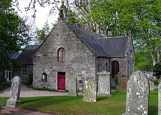
Eassie is a village located along the A94 road in Angus, Scotland. The church in Eassie is dedicated to Saint Fergus, a monk who worked at nearby Glamis. Eassie is noted for the presence of the Eassie Stone, a carved Pictish stone, which resides in the ruins of Eassie Old Church.
Milton Ness is a coastal landform along the coast of the North Sea approximately two miles south of the village of Johnshaven, Scotland. This headland feature includes a red sandstone cliff formation. Certain prehistoric features are found in the vicinity of Milton Ness, including the Stone of Morphie located somewhat to the west.
May Craig is a rocky island situated along the North Sea coast of Aberdeenshire, Scotland. May Craig lies about one half mile south of Newtonhill and a mile northeast of the village of Muchalls. A small islet of the same name lies three miles to the north-northeast.

Ark Hill is a mountainous landform within the Sidlaw Hills in Angus, Scotland. This location has been proposed as a windfarm for generating renewable electrical power. Approximately two kilometres to the north is the village of Eassie noted for the presence of the Eassie Stone; this carved Pictish stone is dated prior to the Early Middle Ages.
Newtyle Hill is a mountainous landform in the Sidlaw Hills in Angus, Scotland The vicinity has elements of prehistory including presence of the Eassie Stone, a Pictish stone dating to the Dark Ages.
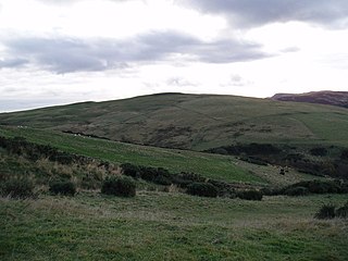
Hatton Hill is a mountain landform in Angus, Scotland in the Sidlaw Hills. Hatton Castle stands on the flanks of Hatton Hill above the village of Newtyle. The general vicinity has elements of prehistory including presence of the Eassie Stone, a Pictish stone dating back to the Dark Ages.

The Mill of Towie is a nineteenth-century mill building, with an attached kiln, situated close the River Isla, approximately 2 miles (3.2 km) south of Keith, Moray in Moray.
References
- C. Michael Hogan. 2007. Stone of Morphie, The Megalithic Portal, ed. A. Burnham)
- John R. Hume. 1976. The Industrial Archaeology of Scotland, Published by Macmillan of Canada, v.2