Millbrook Resort

Last updated

Millbrook Resort
New Zealand location map.svg
Red pog.svg
Location within New Zealand
General information
Location Queenstown, New Zealand
Address1124 Malaghans Rd, Arrowtown 9371
Coordinates 44°56′34″S168°49′05″E / 44.9428038°S 168.8180444°E / -44.9428038; 168.8180444
Website
Official website

Millbrook Resort is a luxury resort near Queenstown, New Zealand. It is located 4 kilometres to the west of the historic gold-mining town of Arrowtown. The resort covers 650 acres of the Wakatipu Basin - a glacial valley bordered by the Crown Range, The Remarkables and Lake Wakatipu.

Contents

The resort includes five restaurants, a bar/café, a spa and a 36 hole golf course.

Millbrook is privately owned by the Ishii family, though individual residences within the resort are owned by a diverse group of investors, largely from New Zealand but also from Australia and around the world.

View of part of Millbrook Millbrook Country Club vista.tif
View of part of Millbrook

Millbrook Declaration

In 1995, Millbrook was the venue for a top-level meeting of Commonwealth heads of government, meeting to design a policy programme of the Commonwealth of Nations, designed to ratify the basic political membership criteria of the Commonwealth. The programme was agreed and announced on 12 November 1995.

Demographics

Millbrook is described by Statistics New Zealand as a rural settlement. It covers 3.32 km2 (1.28 sq mi). [1] It is part of the Wakatipu Basin statistical area. [2]

Historical population
YearPop.±% p.a.
200684    
201387+0.50%
2018123+7.17%
Source: [3]

Millbrook had a population of 123 at the 2018 New Zealand census, an increase of 36 people (41.4%) since the 2013 census, and an increase of 39 people (46.4%) since the 2006 census. There were 57 households. There were 63 males and 63 females, giving a sex ratio of 1.0 males per female, with 12 people (9.8%) aged under 15 years, 9 (7.3%) aged 15 to 29, 57 (46.3%) aged 30 to 64, and 45 (36.6%) aged 65 or older.

Ethnicities were 97.6% European/Pākehā, 4.9% Māori, 2.4% Pacific peoples, and 2.4% other ethnicities (totals add to more than 100% since people could identify with multiple ethnicities).

Although some people objected to giving their religion, 53.7% had no religion, and 46.3% were Christian.

Of those at least 15 years old, 45 (40.5%) people had a bachelor or higher degree, and 6 (5.4%) people had no formal qualifications. The employment status of those at least 15 was that 39 (35.1%) people were employed full-time, and 21 (18.9%) were part-time. [3]

Related Research Articles

<span class="mw-page-title-main">Eketāhuna</span> Town in Manawatū-Whanganui, New Zealand

Eketāhuna is a small rural settlement, in the south of the Tararua District and the Manawatū-Whanganui region of New Zealand's North Island.

<span class="mw-page-title-main">Glenorchy, New Zealand</span> Town in Otago, New Zealand

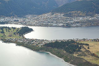
Glenorchy is a small settlement at the northern end of Lake Wakatipu in the South Island region of Otago, New Zealand. It is approximately 45 km (28 mi) by road or boat from Queenstown, the nearest large town. There are two pubs, a café and a range of small shops in the town catering mainly to tourists but also to the small resident population. There is also a small airstrip which caters to small planes.

<span class="mw-page-title-main">Taieri Mouth</span> Rural settlement in Otago, New Zealand

Taieri Mouth is a small fishing village at the mouth of the Taieri River, New Zealand. Taieri Island (Moturata) lies in the ocean several hundred metres off the river's mouth.

<span class="mw-page-title-main">Kingston, New Zealand</span> Rural settlement in Otago, New Zealand

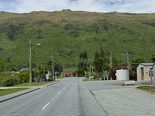
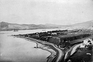
Kingston is a small town at the southernmost end of Lake Wakatipu, just north of the border of Otago and Southland, in New Zealand's South Island. It is 47 kilometres south of Queenstown by a road, "The Devil's Staircase", which winds between the lake to the west and The Remarkables mountains to the east. It is 70 kilometres north of Lumsden, and close to the headwaters of the Mataura River.

Glenavy is a small town in the South Island of New Zealand. It is located at the southern extreme of the Canterbury region on the alluvial fan of the Waitaki River, three kilometres from the river's outflow into the Pacific Ocean.

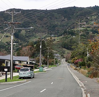
Kaniere is a small town in the Westland District of the West Coast region of New Zealand's South Island. Hokitika lies to the north-west, and the Hokitika River flows past to the south-west.

Pamapuria is a locality in Northland, New Zealand. It lies on State Highway 1 about 10 km east of Kaitaia.

Maromaku is a locality in the Northland Region of the North Island of New Zealand. Kawakawa is north, and Towai is southeast. State Highway 1 runs past Maromaku to the north, and the North Auckland Line runs through it.

<span class="mw-page-title-main">The Pines Beach</span> Human settlement in Waimakariri District, Canterbury Region, New Zealand

The Pines Beach is a small town situated roughly 4 km east of Kaiapoi in the Canterbury region of the South Island of New Zealand. It is 1 km north of the mouth of the Waimakariri River. It takes its name from its close proximity to both a pine forest and the beach.

<span class="mw-page-title-main">Wakatipu Basin</span>

The Whakatipu Basin is a plain surrounded by mountains in Queenstown Lakes District, in the southern South Island of New Zealand.

Tahuna is a small rural settlement located 18 km north of Morrinsville. In the Māori language Tahuna means sandbank, likely to refer to the sandbanks along the nearby Piako River, where a Māori settlement started. Tahuna is seen as the upper limit for navigatable travel on the Piako River. The settlement has a rugby club, a lawn bowls club, a golf course and various shops.

<span class="mw-page-title-main">Gibbston</span> Community in Otago, New Zealand

Gibbston is a community in the Wakatipu Basin in the Otago region of the South Island, New Zealand. Through the valley runs the Kawarau River which forms the Kawarau Gorge.

<span class="mw-page-title-main">Closeburn, New Zealand</span> Locality in Queenstown Lakes District, Otago, New Zealand

Closeburn is a locality in Queenstown-Lakes District in the South Island of New Zealand. It is located a 10-minute drive from Queenstown on the Glenorchy–Queenstown Road.

<span class="mw-page-title-main">Mokai</span> Settlement in Waikato, New Zealand

Mokai is a rural community in the Taupo District and Waikato region of New Zealand's North Island.

<span class="mw-page-title-main">Todds Valley</span> Township in Nelson, New Zealand

Todds Valley is a small township to the north of Nelson, New Zealand. It lies to the southeast of State Highway 6, immediately to the north of Marybank, New Zealand at the northern tip of Nelson Haven.

Annesbrook is an industrial suburb of Nelson, New Zealand.

Rangiuru is a rural community in the Bay of Plenty of New Zealand's North Island.

<span class="mw-page-title-main">Pipitea, New Zealand</span> Suburb of Wellington City, New Zealand

Pipitea is a central suburb of Wellington, in the Wellington region of New Zealand's North Island.

Holdens Bay is an eastern suburb of Rotorua in the Bay of Plenty region of New Zealand's North Island.

<span class="mw-page-title-main">Queenstown East</span> Suburb in Queenstown, New Zealand

Queenstown East is a residential suburb of Queenstown in the South Island of New Zealand. State Highway 6A runs through it.

References

  1. "ArcGIS Web Application". statsnz.maps.arcgis.com. Retrieved 16 December 2021.
  2. 2018 Census place summary: Wakatipu Basin
  3. 1 2 "Statistical area 1 dataset for 2018 Census". Statistics New Zealand. March 2020. 7028040 and 7028042.